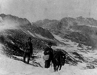
The Pike's Peak Gold Rush was the boom in gold prospecting and mining in the Pike's Peak Country of western Kansas Territory and southwestern Nebraska Territory of the United States that began in July 1858 and lasted until roughly the creation of the Colorado Territory on February 28, 1861. An estimated 100,000 gold seekers took part in one of the greatest gold rushes in North American history.

Lumpkin County is a county located in the north central portion of the U.S. state of Georgia. As of the 2020 census, the population was 33,488. Its county seat is Dahlonega. Lumpkin County is included in the Atlanta-Sandy Springs-Roswell, Georgia Metropolitan Statistical Area.

Dahlonega is the county seat of Lumpkin County, Georgia, United States. As of the 2010 census, the city had a population of 5,242, and in 2018 the population was estimated to be 6,884.

A gold rush or gold fever is a discovery of gold—sometimes accompanied by other precious metals and rare-earth minerals—that brings an onrush of miners seeking their fortune. Major gold rushes took place in the 19th century in Australia, Greece, New Zealand, Brazil, Chile, South Africa, California, the United States, and Canada while smaller gold rushes took place elsewhere.

The Dahlonega Mint was a former branch of the United States Mint built during the Georgia Gold Rush to help the miners get their gold assayed and minted, without having to travel to the Philadelphia Mint. It was located at in Dahlonega, Lumpkin County, Georgia. Coins produced at the Dahlonega Mint bear the "D" mint mark. That mint mark is used today by the Denver Mint, which opened in 1906, over four decades after the Dahlonega Mint closed. All coins from the Dahlonega Mint are gold, in the $1, $2.50, $3, and $5 denominations, and bear dates in the range 1838–1861.

Hydraulic mining is a form of mining that uses high-pressure jets of water to dislodge rock material or move sediment. In the placer mining of gold or tin, the resulting water-sediment slurry is directed through sluice boxes to remove the gold. It is also used in mining kaolin and coal.

Auraria is a ghost town in Lumpkin County, Georgia, United States, southwest of Dahlonega. Its name derives from aurum, the Latin word for gold. In its early days, it was also known variously as Dean, Deans, Nuckollsville, and Scuffle Town.
Crisson Mine was a gold mine in Lumpkin County, Georgia, USA, located just east of Dahlonega. Like many mines in the area, the property probably started as a placer mine during the Georgia Gold Rush. Once the placer deposits had been exhausted, an open pit gold mine was established in 1847 and commercial operations continued until the early 1980s. A small stamp mill was also established here. Much of the gold used for the gold leaf dome of the Georgia State Capitol was mined at this mine, which was among the most productive mines in the Georgia Gold Belt. The mine is located just north of the site of the Consolidated Mine, which is itself north of the Calhoun Mine.

The largest quantities of gold found in the eastern United States were found in the Georgia Gold Belt, extending from eastern Alabama to Rabun County, Georgia. The biggest concentration of gold was found in White, Lumpkin, and northern Cherokee counties in Georgia. The gold in the Georgia Gold Belt was close to 24 karat (100%) purity. Most of the gold was found in eroded rock (saprolite) and mixed in with quartz.
The Georgia Gold Rush was the second significant gold rush in the United States and the first in Georgia, and overshadowed the previous rush in North Carolina. It started in 1829 in present-day Lumpkin County near the county seat, Dahlonega, and soon spread through the North Georgia mountains, following the Georgia Gold Belt. By the early 1840s, gold became difficult to find. Many Georgia miners moved west when gold was found in the Sierra Nevada in 1848, starting the California Gold Rush. Since the 16th century, American Indians in Georgia told European explorers that the small amounts of gold which they possessed came from mountains of the interior. Some poorly documented accounts exist of Spanish or French mining gold in North Georgia between 1560 and 1690, but they are based on supposition and on rumors passed on by Indians. In summing up known sources, W.S. Yeates observed: "Many of these accounts and traditions seem to be quite plausible. Nevertheless, it is hardly probable that the Spaniards would have abandoned mines which were afterwards found to be quite profitable, as those in North Georgia."
The Free Jim Mine was a Georgia Gold Rush gold mine located in the town of Dahlonega in Lumpkin County, Georgia, United States. The mine was started by a free African American named James Boisclair, who arrived in the area in the 1830s from Augusta, Georgia. Apparently, Boisclair discovered gold on a tract of land but, under state law, could not purchase the land since he was black, except through a guardian. A local resident, Joseph J. Singleton became his custodian, consequently allowing Boisclair to purchase the land and start what would become known as the Free Jim Mine. The mine was operated by Bosclair for some years. Boisclair left Georgia following news of the California Gold Rush.

The Franklin-Creighton Mine was a Georgia Gold Rush gold mine located off what is now Yellow Creek Road in the town of Ball Ground in Cherokee County, Georgia. The mine, located along the Etowah River, was initially known as the Franklin Mine because it was started by a widow, Mrs. Mary G. Franklin, who obtained a 40-acre (160,000 m2) lot in the Gold Lottery of 1832. Around 1883, the mine became known as the Creighton Mine or the Franklin-Creighton Mine. This mine was one of the most productive and continued to operate many years after other area mines had ceased operations. Some estimate that it was yielding $1000 per day in 1893 and others place its total production after 1880 at as much as $1,000,000. The mine was shut down in 1913 as a result of a collapsed shaft which caused the mine to flood. As of 2022, only three major structures exist: The stamping mill's concrete foundation, the Franklin residence and doctor's office, and the "Shingle House," the mine's former post office and general store.
William Greeneberry "Green" Russell (1818–1877) was an American prospector and miner.

In the United States, gold mining has taken place continually since the discovery of gold at the Reed farm in North Carolina in 1799. The first documented occurrence of gold was in Virginia in 1782. Some minor gold production took place in North Carolina as early as 1793, but created no excitement. The discovery on the Reed farm in 1799 which was identified as gold in 1802 and subsequently mined marked the first commercial production.
Gold mining in Colorado, a state of the United States, has been an industry since 1858. It also played a key role in the establishment of the state of Colorado.
Gold mining in Alaska, a state of the United States, has been a major industry and impetus for exploration and settlement since a few years after the United States acquired the territory in 1867 from the Russian Empire. Russian explorers discovered placer gold in the Kenai River in 1848, but no gold was produced. Gold mining started in 1870 from placers southeast of Juneau, Alaska.
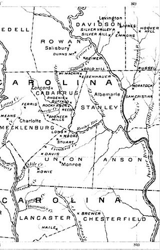
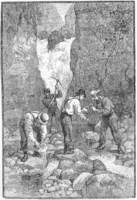
The Carolina Gold Rush, the first gold rush in the United States, followed the discovery of a large gold nugget in North Carolina in 1799, by a 12-year-old boy named Conrad Reed. He spotted the nugget while playing in Meadow Creek on his family's farm in Cabarrus County, North Carolina. Conrad took the 17-pound (7.7 kg) gold nugget home to show his father. However, gold was not commonly seen in their community and the value of the nugget was not understood. The nugget was used as a door stop in the family's home for several years. In 1802, Conrad's father, John Reed, showed the rock to a jeweler, who recognized it as gold and offered to buy it. Reed, still unaware of the real value of his "doorstop," sold it to the jeweler for US$3.50.
Mining in the United States has been active since the beginning of colonial times, but became a major industry in the 19th century with a number of new mineral discoveries causing a series of mining rushes. In 2015, the value of coal, metals, and industrial minerals mined in the United States was US $109.6 billion. 158,000 workers were directly employed by the mining industry.

The Cripple Creek & Victor Gold Mine, formerly and historically the Cresson Mine, is an active gold mine located near the town of Victor, in the Cripple Creek mining district in the US state of Colorado. The richest gold mine in Colorado history, it is the only remaining significant producer of gold in the state, and produced 322,000 troy ounces of gold in 2019, and reported 3.45 million troy ounces of Proven and Probable Reserves as at December 31, 2019. It was owned and operated by AngloGold Ashanti through its subsidiary, the Cripple Creek & Victor Gold Mining Company (CC&V), until 2015, when it sold the mine to Newmont Mining Corporation.

Gold Rush is a reality television series that airs on Discovery and its affiliates worldwide. The series follows the placer gold mining efforts of various family-run mining companies, mostly in the Klondike region of Dawson City, Yukon, Canada, as well as in the U.S. state of Alaska. In its 12th season as of early 2021, prior seasons also included mining efforts in South America and western North America.

