
The Battle of Fallen Timbers was the final battle of the Northwest Indian War, a struggle between Native American tribes affiliated with the Northwestern Confederacy and their British allies, against the nascent United States for control of the Northwest Territory. The battle took place amid trees toppled by a tornado near the Maumee River in northwestern Ohio at the site of the present-day city of Maumee, Ohio.

The Treaty of Greenville, formally titled Treaty with the Wyandots, etc., was a 1795 treaty between the United States and indigenous nations of the Northwest Territory, including the Wyandot and Delaware peoples, that redefined the boundary between indigenous peoples' lands and territory for European American community settlement.

The Bunker Hill Monument is a monument erected at the site of the Battle of Bunker Hill in Boston, Massachusetts, which was among the first major battles between the Red Coats and Patriots in the American Revolutionary War. The 221-foot granite obelisk was erected between 1825 and 1843 in Charlestown, Massachusetts, with granite from nearby Quincy conveyed to the site via the purpose-built Granite Railway, followed by a trip by barge. There are 294 steps to the top.

Fort Brown was a military post of the United States Army in Cameron County, Texas, during the latter half of the 19th century and the early part of the 20th century. Established in 1846, it was the first US Army military outpost of the recently annexed state. Confederate Army troops stationed there saw action during the American Civil War. In the early 20th century, it was garrisoned in relation to military activity over border conflicts with Mexico. Surviving elements of the fort were designated as a National Historic Landmark in 1960.
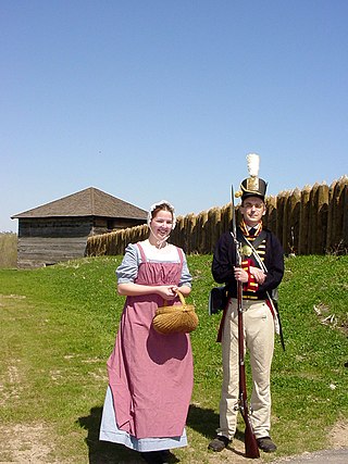
Fort Meigs was a United States fortification along the Maumee River in what is now Perrysburg, Ohio during the War of 1812. The British Army, supported by Tecumseh's Confederacy, failed to capture the fort during the siege of Fort Meigs. It is named in honor of Ohio governor Return J. Meigs Jr., for his support in providing General William Henry Harrison with militia and supplies for the line of forts along the Old Northwest frontier.

Fort Recovery was a United States Army fort ordered built by General "Mad" Anthony Wayne during what is now termed the Northwest Indian War. Constructed from late 1793 and completed in March 1794, the fort was built along the Wabash River, within two miles of what became the Ohio state border with Indiana. A detachment of Wayne's Legion of the United States held off an attack from combined Indian forces on June 30, 1794. The fort was used as a reference in drawing treaty lines for the 1795 Treaty of Greenville, and for later settlement. The fort was abandoned in 1796.

The San Jacinto Monument is a 567.31-foot-high (172.92-meter) column located on the Houston Ship Channel in unincorporated Harris County, Texas, about 16 miles due east of downtown Houston. The monument is topped with a 220-ton star that commemorates the site of the Battle of San Jacinto, the decisive battle of the Texas Revolution. The monument, constructed between 1936 and 1939 and dedicated on April 21, 1939, is the world's tallest masonry column and is part of the San Jacinto Battleground State Historic Site. By comparison, the Washington Monument is 554.612 feet (169.046 m) tall, which is the tallest stone monument in the world. The column is an octagonal shaft topped with a 34-foot (10 m) Lone Star – the symbol of Texas. Visitors can take an elevator to the monument's observation deck for a view of Houston and the San Jacinto battlefield.

National Military Park, National Battlefield, National Battlefield Park, and National Battlefield Site are four designations for 25 battle sites preserved by the United States federal government because of their national importance. The designation applies to "sites where historic battles were fought on American soil during the armed conflicts that shaped the growth and development of the United States...."

Fort Defiance was built by General "Mad" Anthony Wayne in the second week of August 1794 at the confluence of the Auglaize and Maumee rivers. It was the one of a line of defenses constructed by American forces in the campaign leading to the Northwest Indian War's Battle of Fallen Timbers on August 20, 1794.

Fort Miami (Miamis) was a British fort built in spring 1794 on the Maumee River in what was at the time territory claimed by the United States, and designated by the federal government as the Northwest Territory. The fort was located at the eastern edge of present-day Maumee, Ohio, southwest of Toledo. The British built the fort to forestall a putative assault on Fort Detroit by Gen. "Mad" Anthony Wayne's army, then advancing northward in southwestern Ohio.

George Rogers Clark National Historical Park, located in Vincennes, Indiana, on the banks of the Wabash River at what is believed to be the site of Fort Sackville, is a United States National Historical Park. President Calvin Coolidge authorized a classical memorial and President Franklin D. Roosevelt dedicated the completed structure in 1936.
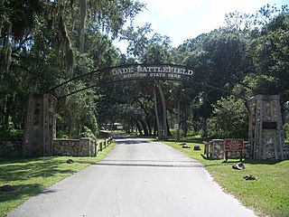
Dade Battlefield Historic State Park is a state park located on County Road 603 between Interstate 75 and U.S. Route 301 in Sumter County, Florida. The 80-acre (32 ha) park includes 40 acres (160,000 m2) of pine flatwoods and a live oak hammock. Also called the Dade Massacre site, it preserves the Second Seminole War battlefield where tribal Seminole warriors fought soldiers under the command of Major Francis L. Dade on December 28, 1835. Each year, on the weekend after Christmas, the Dade Battlefield Society sponsors a reenactment of the battle that started the Second Seminole War.

Stony Point Battlefield is a historic site in Rockland County, New York; the location of the 1779 Battle of Stony Point during the American Revolutionary War. It is a National Historic Landmark and has a museum.

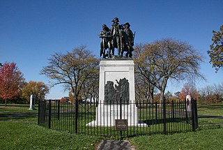
The Red Bank Battlefield is located along the Delaware River in National Park, Gloucester County, New Jersey. It was the location of the Battle of Red Bank in the American Revolutionary War on October 22, 1777. Fort Mercer and its sister, Fort Mifflin in Pennsylvania, defended the river and prevented the British from using it for transportation. The forts successfully delayed the British, but in the end, they were both destroyed or abandoned.
The Fallen Timbers Battlefield was the site of the Battle of Fallen Timbers on 20 August 1794. The battle, a decisive American victory over Native American and British opponents, effectively ended the Northwest Indian War, securing the Old Northwest for settlement. An area believed to be the battle site, located in Maumee, Ohio, was declared a National Historic Landmark in 1960. That site, now the Fallen Timbers State Memorial, is about 0.25 miles (0.40 km) south of the actual battlefield, which was identified in 1995, and much of which is now preserved as part of the Fallen Timbers Battlefield and Fort Miamis National Historic Site along with Fort Miami. The National Historic Site was established in 1999 as a partnership between the National Park Service, Toledo MetroParks, and the Ohio Historical Society.

The following is an alphabetical list of articles related to the U.S. state of Ohio.

The River Raisin National Battlefield Park preserves the site of the Battle of Frenchtown as the only national battlefield marking a site of the War of 1812. It was established as the 393rd unit of the United States National Park Service under Title VII of the Omnibus Public Land Management Act, which was signed into law on March 30, 2009. The park is located in the city of Monroe in Monroe County, Michigan. It was designated as a Michigan Historic Site on February 18, 1956 and was added to the National Register of Historic Places on December 10, 1982. The house at 1403 East Elm Avenue was added to the National Register listing in 2019. It officially began operation as a national park unit on October 22, 2010.

Lytle Park Historic District is a historic district in Cincinnati, Ohio, United States. Roughly bounded by 3rd, 5th, Sycamore, Commercial Sq., and Butler Sts. in downtown Cincinnati, it centers on Lytle Park.
The Civil War Trust's Civil War Discovery Trail is a heritage tourism program that links more than 600 U.S. Civil War sites in more than 30 states. The program is one of the White House Millennium Council's sixteen flagship National Millennium Trails. Sites on the trail include battlefields, museums, historic sites, forts and cemeteries.


