
An encyclopedia or encyclopaedia is a reference work or compendium providing summaries of knowledge, either general or special, in a particular field or discipline. Encyclopedias are divided into articles or entries that are arranged alphabetically by article name or by thematic categories, or else are hyperlinked and searchable. Encyclopedia entries are longer and more detailed than those in most dictionaries. Generally speaking, encyclopedia articles focus on factual information concerning the subject named in the article's title; this is unlike dictionary entries, which focus on linguistic information about words, such as their etymology, meaning, pronunciation, use, and grammatical forms.

The Encyclopædia Britannica is a general knowledge English-language encyclopaedia. It has been published by Encyclopædia Britannica, Inc. since 1768, although the company has changed ownership seven times. The encyclopaedia is maintained by about 100 full-time editors and more than 4,000 contributors. The 2010 version of the 15th edition, which spans 32 volumes and 32,640 pages, was the last printed edition. Since 2016, it has been published exclusively as an online encyclopaedia.

The Encyclopædia Britannica Eleventh Edition (1910–1911) is a 29-volume reference work, an edition of the real Encyclopædia Britannica. It was developed during the encyclopaedia's transition from a British to an American publication. Some of its articles were written by the best-known scholars of the time. This edition of the encyclopaedia, containing 40,000 entries, has entered the public domain and is readily available on the Internet. Its use in modern scholarship and as a reliable source has been deemed problematic due to the outdated nature of some of its content. Modern scholars have deemed some articles as cultural artifacts of the 19th and early 20th centuries. Additionally, the 11th edition has retained considerable value as a time capsule of scientific and historical information, as well as scholarly attitudes of the era immediately preceding World War I.
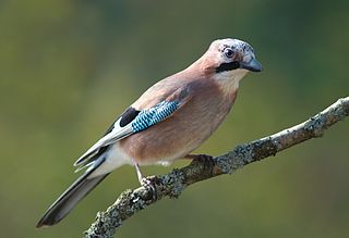
A jay is a member of a number of species of medium-sized, usually colorful and noisy, passerine birds in the crow family, Corvidae. The evolutionary relationships between the jays and the magpies are rather complex. For example, the Eurasian magpie seems more closely related to the Eurasian jay than to the East Asian blue and green magpies, whereas the blue jay is not closely related to either. The Eurasian jay distributes oak acorns, contributing to the growth of oak woodlands over time.
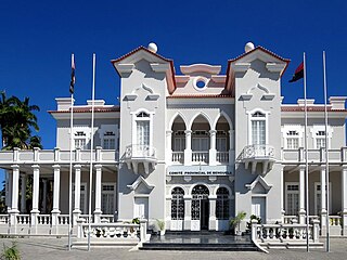
Benguela is a city in western Angola, capital of Benguela Province. Benguela is one of Angola's most populous cities with a population of 555,124 in the city and 561,775 in the municipality, at the 2014 census.

Coats Land is a region in Antarctica which lies westward of Queen Maud Land and forms the eastern shore of the Weddell Sea, extending in a general northeast–southwest direction between 20°00′W and 36°00′W. The northeast part was discovered from the Scotia by William S. Bruce, leader of the Scottish National Antarctic Expedition, 1902-1904. He gave the name Coats Land for James Coats, Jr., and Major Andrew Coats, the two chief supporters of the expedition.

The Institute of the Italian Encyclopaedia Treccani, also known as the Treccani Institute, is a cultural institution of national interest, active in the publishing field, founded by Giovanni Treccani and Giovanni Gentile in 1925.
Encyclopædia Britannica, Inc. is the company known for publishing the Encyclopædia Britannica, the world's oldest continuously published encyclopaedia. The company also owns the American dictionary publisher Merriam-Webster. Originally founded in Edinburgh, Scotland and historically British, the company is now based in Chicago, Illinois, in the United States.

Majar or Macar was a medieval city of Golden Horde in 13th-14th centuries. It once played a major role in the trade between Idel-Ural, Caucasus and the Black Sea region. In 1310–1311 the city minted its own money. In 1395 it was sacked by troops of Timur.
The Chinde River is a distributary of the Zambezi river delta in Mozambique. The town of Chinde is located on its banks.

Paramonga District is one of five districts of the province Barranca in Peru.
Mont Sângbé National Park is a national park in Ivory Coast. The Encyclopædia Britannica lists it among the "principal national parks of the world". It acquired national park status in 1976.
Crystal Hill is a hamlet in Terrell Rural Municipality No. 101 in the province of Saskatchewan, Canada. The hamlet is located 21 km east of Highway 36 on Highway 713. Very little remains of Crystal Hill.

The Principality of Samos was an autonomous tributary state of the Ottoman Empire from 1834 to 1912. The island of Samos participated in the Greek War of Independence and had successfully resisted several Turkish and Egyptian attempts to occupy it, but it was not included with the boundaries of the newly independent Kingdom of Greece after 1832. Instead, in 1834 the island was granted self-government as a semi-independent state.
Walcrow River, a watercourse of the Manning River catchment, is located in the Northern Tablelands and Mid North Coast districts of New South Wales, Australia.

The Battle of Kidodi was fought during the East African Campaign of World War I.

Rumyana Glacier is the 6 nautical miles long and 2 nautical miles wide glacier on the east side of north-central Sentinel Range in Ellsworth Mountains, Antarctica, situated northwest of Patton Glacier and southeast of Delyo Glacier. It drains the east slopes of Mount Giovinetto and the north slopes of Evans Peak, and flows northeastwards to join Ellen Glacier northwest of Mount Jumper.
Vicha Glacier is the 27 km long and 6 km wide glacier in Gromshin Heights on the east side of northern Sentinel Range in Ellsworth Mountains, Antarctica. It is situated northeast of Newcomer Glacier and southwest of Yamen Glacier. The glacier drains southwards along the east slopes of Mount Ulmer and Mount Ojakangas, then turns southeast at Mount Washburn, flows east of Mount Cornwell and Mount Warren, and southwest of Branishte Peak, and together with Newcomer Glacier joins Rutford Ice Stream south of Foros Spur.
Qossiyeh is a Syrian village located in Wadi al-Uyun Nahiyah in Masyaf District, Hama. According to the Syria Central Bureau of Statistics (CBS), Qossiyeh had a population of 645 in the 2004 census.
Wickham National Park is a national park in South East Queensland, Australia. The park is located in Cedar Creek near Yarrabilba. Bushwalking, mountain bike riding and horseriding are popular activities taken place in the park. Wickham National Park has a sub-tropical climate and lies within the Albert River water catchment.