
The Brooks–Baxter War, also known as the Brooks–Baxter Affair, Arkansas Civil War, or the Second American Civil War was an attempt made by failed gubernatorial candidate Joseph Brooks of the “Brindle-tail” faction of Arkansas' Republican Party to take control of the state from Elisha Baxter, who was the Republican governor. The victor in the end was the Baxter administration, also known as the "Minstrels", supported by some "carpetbaggers" and Democrats over the Brindle-tails supported by "scalawags" and "freedmen".
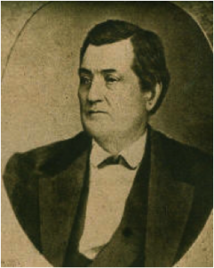
Elisha Baxter was an American businessman and politician who served as the 10th governor of Arkansas from 1873 to 1874.

Mount Katahdin is the highest mountain in the U.S. state of Maine at 5,269 feet (1,606 m). Named Katahdin, which means "Great Mountain", by the Penobscot Native Americans, it is within Northeast Piscataquis, Piscataquis County, and is the centerpiece of Baxter State Park. It is a steep, tall massif formed from a granite intrusion weathered to the surface. The flora and fauna on the mountain are typical of those found in northern New England, with the summit hosting fragile and endangered alpine tundra.

The Chenango River is a 90-mile-long (140 km) tributary of the Susquehanna River in central New York in the United States. It drains a dissected plateau area in upstate New York at the northern end of the Susquehanna watershed.

The West Branch Delaware River is one of two branches that form the Delaware River. It is approximately 90 mi (144 km) long, and flows through the U.S. states of New York and Pennsylvania. It winds through a mountainous area of New York in the western Catskill Mountains for most of its course, before joining the East Branch along the northeast border of Pennsylvania with New York. Midway or so it is empounded by the Cannonsville Dam to form the Cannonsville Reservoir, both part of the New York City water supply system for delivering drinking water to the City.

The Eisenhower Range is a majestic mountain range, about 45 nautical miles long and rising to 3,070 metres (10,070 ft), which rises between Reeves Névé on the west, Reeves Glacier on the south, and Priestley Glacier on the north and east, in Victoria Land, Antarctica. The range is flat topped and descends gradually to Reeves Névé, but is steep cliffed and marked by sharp spurs along the Priestley Glacier. It is in the north of the Prince Albert Mountains, southwest of the Deep Freeze Range

The Priestley Glacier is a major valley glacier, about 60 nautical miles long, originating at the edge of the Polar Plateau of Victoria Land, Antarctica. The glacier drains southeast between the Deep Freeze Range and Eisenhower Range to enter the northern end of the Nansen Ice Sheet. It was first explored by the Northern Party of the British Antarctic Expedition, 1910–13, and named for Raymond Priestley, a geologist with the Northern Party.

The Sacandaga River is a 64-mile-long (103 km) river in the northern part of New York in the United States. Its name comes from the Native American Sa-chen-da'-ga, meaning "overflowed lands".

Stony Clove Creek is a 10.3-mile-long (16.6 km) creek in the Catskill Mountains in New York. It is a tributary of Esopus Creek, which in turn is a tributary of the Hudson River. It joins the Esopus in the village of Phoenicia, and has two smaller tributaries up north of Phoenicia.
Nauvoo State Park is an Illinois state park on 148 acres (60 ha) in Hancock County, Illinois, United States near the banks of the Mississippi River. It contains 13-acre manmade lake named Lake Horton, the Rheinberger House Museum, and Illinois’ oldest vineyard.

Baxter County Airport, is a county-owned public-use airport located four nautical miles northwest of the central business district of Mountain Home, a city in Baxter County, Arkansas, United States. It was known as Baxter County Airport until 2005. It changed its name back to Baxter County Airport due to confusion with the close proximity of Ozark, Arkansas and Ozark, Missouri, both of which have airports. The airport used to be served by Lone Star Airlines, which operated services to Dallas-Fort Worth International in the mid-1990s.

Richmond Inner Harbor is a deepwater body of water in Richmond, California.

The Titicus River is an 8.5-mile-long (13.7 km) river in southwestern Connecticut and southeastern New York that drains into the Titicus Reservoir, part of New York City's water supply system. Part of both the Croton River watershed and the system's Croton Watershed, has a 23.8 square miles (62 km2) drainage area. It is one of the few rivers with headwaters in Connecticut that is part of the system. The source of the river is in Ridgefield, Connecticut. About one mile down stream, the stream marks the southern boundary of the Kiahs Brook Reserve. Another 0.5 miles downriver, it joins with Kiahs Brook, and then runs fairly close to Route 116. Once past the New York border, the Titicus River still runs close to New York 116 until emptying into the Titicus Reservoir. After the Titicus Reservoir, it runs another 0.5 miles, under I-684, and drains into the Muscoot Reservoir.

The West Branch Penobscot River is a 117-mile-long (188 km) tributary of the Penobscot River through the North Maine Woods in Maine. The river is also known as Abocadneticook, Kahgognamock, and Kettegwewick.

The Undergraduate Student Government (USG) at Stony Brook University is a governing body representing the undergraduate students of Stony Brook University. As with most student governments in the United States, one of USG's main functions is to recognize, fund and regulate student organizations. The USG is composed of an executive, a legislative, and a judicial branch. Along with the Graduate Student Organization, USG is the only other organization authorized to distribute the Student Activity Fee (SAF) in a viewpoint-neutral manner. In accordance with State University of New York Policies and Procedures, the mandatory SAF provides the USG with an annual budget of approximately $3.1 million, independently of the state budget.
Arkana is an unincorporated community in Baxter County, Arkansas, United States. The community is located along Arkansas Highway 201.
Baxter is an unincorporated community in Harlan County, Kentucky, United States.

Trout Brook, also called Ball Brook, is a cold water tributary of the Quinapoxet River located in Holden, Massachusetts. Trout Brook is stocked with trout each spring by the Massachusetts Fisheries and Wildlife Division. As the Quinapoxet River is part of the water supply for Worcester, Massachusetts, both the Quinapoxet and all of its major tributaries including Trout Brook are monitored by the USGS for water quality.
Charlotte Creek is a river located in Delaware County, New York. Charlotte Creek borders the southern border of Otsego County, New York for a few miles near the mouth. The creek converges with the Susquehanna River by Emmons, New York.

Bowmans Creek is a river in Montgomery County, New York. It begins west of the hamlet of Hessville and just south of the hamlet of Ripple Corners. It then flows in a mostly southeast direction for a few miles passing through the hamlet of Sprout Brook before flowing into the Canajoharie Creek just east of the hamlet of Sprout Brook.
