Bayaguana

Last updated
Bayaguana
Bayaguana, Republica Dominicana, santuario.jpg
Church
Escudo del Municipio Bayaguana.png
Dominican Republic relief location map.jpg
Red pog.svg
Bayaguana
Coordinates: 18°45′N69°38′W / 18.750°N 69.633°W / 18.750; -69.633
CountryFlag of the Dominican Republic.svg  Dominican Republic
Province Monte Plata
Founded1606
Area
[1]
  Total877.99 km2 (338.99 sq mi)
Elevation
[2]
61 m (200 ft)
Population
 (2012)
  Total34,786
  Density40/km2 (100/sq mi)
   Urban
19,001
   Rural
15,785
Municipal Districts 0
Distance to
 Monte Plata

21 km

Bayaguana is a municipality ( municipio ) of the Monte Plata province in the Dominican Republic. [3]

Contents

As of the Dominican Republic's 2002 census, the municipality had a total population of 34,786 inhabitants, of which 19,001 resided in urban areas and 15,785 in rural areas.

History

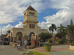
Bayaguana was founded in 1606, when Spain resettled colonists from the northern and western part of Hispaniola closer to Santo Domingo, under the government eviction programme known as the devastations of Osorio. Spanish colonists from La Yaguana and Bayajá (present-day Léogâne and Fort-Liberté, Haiti) were resettled in the town. The economy is centered on cattle-ranching and pineapple and rice farming.

Economy

Waterfall in Bayaguana, Monte Plata province. Wasserfalle bei Bayaguana.jpg
Waterfall in Bayaguana, Monte Plata province.

It operates the agricultural line, as well as part of its land is sown with sugar cane, pineapple and natural pastures for food for the cattle that it has in abundance.

A site of great tourist attraction is located near the town of Bayaguana. It is the Salto de Comate, in the river of the same name, where hundreds of people flock every day to enjoy a bath in its cold waters. There are also the spas of Comatillo, in Comatillo, Salto Alto, in Sierra de Agua, among others. In turn, part of one of the main national parks, Los Haitises National Park, is located in Bayaguana.

Climate

Climate data for Bayaguana (1991–2020)
MonthJanFebMarAprMayJunJulAugSepOctNovDecYear
Mean daily maximum °C (°F)30.0
(86.0)
30.6
(87.1)
31.2
(88.2)
31.7
(89.1)
31.6
(88.9)
32.6
(90.7)
32.9
(91.2)
32.8
(91.0)
32.7
(90.9)
32.2
(90.0)
31.1
(88.0)
30.3
(86.5)
31.6
(88.9)
Daily mean °C (°F)24.4
(75.9)
24.7
(76.5)
25.3
(77.5)
26.1
(79.0)
26.8
(80.2)
27.6
(81.7)
27.8
(82.0)
27.8
(82.0)
27.6
(81.7)
27.2
(81.0)
26.1
(79.0)
24.9
(76.8)
26.3
(79.3)
Mean daily minimum °C (°F)18.7
(65.7)
18.8
(65.8)
19.3
(66.7)
20.6
(69.1)
21.9
(71.4)
22.6
(72.7)
22.8
(73.0)
22.7
(72.9)
22.5
(72.5)
22.2
(72.0)
21.1
(70.0)
19.5
(67.1)
21.1
(70.0)
Average precipitation mm (inches)60.6
(2.39)
58.2
(2.29)
73.6
(2.90)
161.3
(6.35)
255.6
(10.06)
190.6
(7.50)
212.2
(8.35)
253.8
(9.99)
218.3
(8.59)
193.3
(7.61)
105.2
(4.14)
58.4
(2.30)
1,841.2
(72.49)
Source: National Oceanic and Atmospheric Administration [4]
Climate data for Bayaguana (1971–2000)
MonthJanFebMarAprMayJunJulAugSepOctNovDecYear
Record high °C (°F)33.5
(92.3)
34.0
(93.2)
36.5
(97.7)
36.5
(97.7)
36.0
(96.8)
36.0
(96.8)
35.6
(96.1)
39.5
(103.1)
35.6
(96.1)
35.5
(95.9)
35.0
(95.0)
35.5
(95.9)
39.5
(103.1)
Mean daily maximum °C (°F)27.2
(81.0)
27.5
(81.5)
28.2
(82.8)
28.7
(83.7)
28.9
(84.0)
29.4
(84.9)
29.6
(85.3)
29.6
(85.3)
29.5
(85.1)
29.2
(84.6)
28.4
(83.1)
27.3
(81.1)
28.6
(83.5)
Daily mean °C (°F)24.1
(75.4)
24.3
(75.7)
24.9
(76.8)
25.6
(78.1)
26.3
(79.3)
27.0
(80.6)
27.1
(80.8)
27.0
(80.6)
27.0
(80.6)
26.6
(79.9)
25.8
(78.4)
24.5
(76.1)
25.9
(78.5)
Mean daily minimum °C (°F)18.7
(65.7)
18.7
(65.7)
19.1
(66.4)
20.1
(68.2)
21.3
(70.3)
22.1
(71.8)
22.0
(71.6)
22.0
(71.6)
21.9
(71.4)
21.5
(70.7)
20.8
(69.4)
19.4
(66.9)
20.6
(69.1)
Record low °C (°F)14.0
(57.2)
12.5
(54.5)
13.2
(55.8)
14.0
(57.2)
14.6
(58.3)
19.0
(66.2)
19.0
(66.2)
18.0
(64.4)
18.8
(65.8)
17.7
(63.9)
16.1
(61.0)
13.4
(56.1)
12.5
(54.5)
Average rainfall mm (inches)58.5
(2.30)
71.3
(2.81)
82.5
(3.25)
134.4
(5.29)
253.5
(9.98)
196.4
(7.73)
208.8
(8.22)
267.8
(10.54)
241.7
(9.52)
194.9
(7.67)
114.0
(4.49)
59.4
(2.34)
1,883.2
(74.14)
Average rainy days (≥ 1.0 mm)7.37.27.010.113.913.114.416.416.214.710.98.2139.4
Average relative humidity (%)77.774.973.175.179.279.179.381.382.482.781.279.278.8
Source: ONAMET [5]
Climate data for Bayaguana (1961–1990)
MonthJanFebMarAprMayJunJulAugSepOctNovDecYear
Record high °C (°F)36.0
(96.8)
35.5
(95.9)
36.5
(97.7)
36.5
(97.7)
37.0
(98.6)
37.5
(99.5)
37.5
(99.5)
39.5
(103.1)
37.5
(99.5)
37.0
(98.6)
36.0
(96.8)
37.8
(100.0)
39.5
(103.1)
Mean daily maximum °C (°F)30.1
(86.2)
30.6
(87.1)
31.5
(88.7)
31.8
(89.2)
32.2
(90.0)
32.6
(90.7)
32.7
(90.9)
32.7
(90.9)
32.7
(90.9)
32.4
(90.3)
31.5
(88.7)
30.1
(86.2)
31.7
(89.1)
Daily mean °C (°F)24.7
(76.5)
24.9
(76.8)
25.6
(78.1)
26.2
(79.2)
27.0
(80.6)
27.5
(81.5)
27.6
(81.7)
27.6
(81.7)
27.6
(81.7)
27.2
(81.0)
26.4
(79.5)
25.0
(77.0)
26.4
(79.5)
Mean daily minimum °C (°F)19.3
(66.7)
19.3
(66.7)
19.7
(67.5)
20.6
(69.1)
21.8
(71.2)
22.5
(72.5)
22.6
(72.7)
22.5
(72.5)
22.5
(72.5)
22.1
(71.8)
21.3
(70.3)
19.9
(67.8)
21.2
(70.2)
Record low °C (°F)14.0
(57.2)
12.5
(54.5)
13.2
(55.8)
14.0
(57.2)
14.6
(58.3)
19.0
(66.2)
18.0
(64.4)
18.0
(64.4)
18.8
(65.8)
17.7
(63.9)
16.1
(61.0)
13.4
(56.1)
12.5
(54.5)
Average rainfall mm (inches)45.4
(1.79)
61.1
(2.41)
78.8
(3.10)
126.8
(4.99)
232.0
(9.13)
229.6
(9.04)
227.3
(8.95)
281.4
(11.08)
217.6
(8.57)
200.8
(7.91)
117.0
(4.61)
58.3
(2.30)
1,876.1
(73.86)
Average rainy days (≥ 1.0 mm)6.16.06.38.113.514.214.216.215.515.49.77.2132.4
Average relative humidity (%)77.574.673.274.978.879.379.481.382.382.881.179.278.7
Source: NOAA [6]

Related Research Articles

<span class="mw-page-title-main">Monte Plata Province</span> Province of the Dominican Republic

Monte Plata is an eastern province of the Dominican Republic, and also the name of its capital city. It was split from San Cristóbal in 1992.

<span class="mw-page-title-main">Cabrera, María Trinidad Sánchez</span> Place in María Trinidad Sánchez, Dominican Republic

Cabrera is a town in María Trinidad Sánchez province, Dominican Republic. It is located at the eastern end of the country's north coast, at the western extreme of the Scottish Bay, 130 kilometers north of Santo Domingo.

<span class="mw-page-title-main">Neiba</span> Place in Baoruco, Dominican Republic

Neiba is a city in the southwest of the Dominican Republic. It is the capital city of the Baoruco province, and is located 180 kilometres west of the national capital, Santo Domingo, close to the shore of Lake Enriquillo, the largest lake in the West Indies.

<span class="mw-page-title-main">Hato Mayor del Rey</span> City in the Dominican Republic

Hato Mayor del Rey is the capital of Hato Mayor Province, Dominican Republic. It is bordered on the North by the municipalities of El Valle and Sabana de la Mar, on the South by the San Pedro de Macorís Province, on the East by the El Seibo Province and on the West by the municipality of Bayaguana, Monte Plata. It is located 27 kilometers from the San Pedro de Macorís Province and 110 kilometers from the capital city of Santo Domingo. Hato Mayor del Rey has a population of 70,141 inhabitants, and is divided into three municipal districts: Yerba Buena, Guayabo Dulce and Mata Palacio.

<span class="mw-page-title-main">Azua, Dominican Republic</span> Municipality in Azua, Dominican Republic

Azua de Compostela, also known simply as Azua, is a city, municipality (municipio) and capital of Azua Province in the southern region of Dominican Republic. Founded in 1504, Azua is one of the oldest European settlements in the Americas. The town is located 100 kilometres west of the national capital, Santo Domingo.

<span class="mw-page-title-main">Monte Plata</span> Municipality in Dominican Republic

Monte Plata is a town and municipality (municipio) and the capital of the Monte Plata province in the Dominican Republic. It includes the municipal districts of Boyá, Chirino, and Don Juan.

San Ignacio de Sabaneta is the capital and a municipality of Santiago Rodriguez in the northwestern part of the Dominican Republic. It is usually called only Sabaneta or Santiago Rodríguez.

Pimentel is a city in the province Duarte and it is the 2nd largest in Duarte and the 25th largest city in the Dominican Republic.

Salcedo is the capital city of the Hermanas Mirabal Province in the Dominican Republic. It is the birthplace of the Dominican heroines, the Mirabal sisters, who died in the struggle against the dictator Rafael Trujillo. A museum in the town commemorates three of sisters; it was tended to by the remaining sister, Bélgica (Dedé) Mirabal, until her death on February 1, 2014.

<span class="mw-page-title-main">San José de las Matas</span> Place in Santiago, Dominican Republic

San José de las Matas, also known as Sajoma, is an important municipality (municipio) of the Santiago province in the Dominican Republic. The mayor of Sajoma is Alfredo Reyes. There have been many positive changes in the last four years including the addition of a 911 system. Within the municipality there are three municipal districts : El Rubio, La Cuesta and Las Placetas.

<span class="mw-page-title-main">Yamasá</span> Municipality in Monte Plata, Dominican Republic

Yamasá is a municipality (municipio) of the Monte Plata province in the Dominican Republic. It includes the municipal district of Los Botados. Yamasa is north of the capital city of Santo Domingo. The Rio Ozama, one of Dominican Republic's longest rivers, passes through Yamasa.

Villa Riva is a municipality (municipio) of the Duarte Province in the Dominican Republic.

<span class="mw-page-title-main">Cevicos</span> Place in Sánchez Ramírez, Dominican Republic

Cevicos is a town and municipality in the Sánchez Ramírez province of the Dominican Republic. Municipal population, as of 2012, is of 12,589. Town's proper population is of 4,285.

<span class="mw-page-title-main">Gaspar Hernández</span> Place in Espaillat, Dominican Republic

Gaspar Hernández is a small city in Espaillat province on the North Coast Dominican Republic.

Hondo Valle is a town in the Elías Piña province of the Dominican Republic characterized by its beautiful mountains and cold climate.

<span class="mw-page-title-main">Restauración</span> Place in Dajabón, Dominican Republic

Restauración is the third largest city in the province of Dajabon, Dominican Republic. It is located in the northwest portion of the island, in the Cibao region.

<span class="mw-page-title-main">Sabana de la Mar</span> Place in Hato Mayor, Dominican Republic

Sabana de la Mar, usually spelled in English as Savana de la Mar, is a town in the Hato Mayor province of the Dominican Republic. Sabana de la Mar is located in the northeastern region of Dominican Republic, on the southern side of Samaná Bay. It is an urban area with 508.52 km2.

Río San Juan is a municipality in the María Trinidad Sánchez province of the Dominican Republic.

<span class="mw-page-title-main">Mao, Dominican Republic</span> Place in Valverde, Dominican Republic

The Dominican city of Santa Cruz de Mao, or simply Mao, is the head municipality of the Valverde province, in the northwest of the country.

<span class="mw-page-title-main">Pedernales, Dominican Republic</span> Capital of Pedernales Province, Dominican Republic

The Dominican city of Pedernales is the capital of the Pedernales Province, in the Dominican Republic. It is located in the southwest of the country, on the Dominican Republic–Haiti border, and has a crossing to the Haitian town of Anse-à-Pitres.

References

  1. Superficies a nivel de municipios, Oficina Nacional de Estadistica Archived April 17, 2009, at the Wayback Machine
  2. De la Fuente, Santiago (1976). Geografía Dominicana (in Spanish). Santo Domingo, Dominican Republic: Editora Colegial Quisqueyana.
  3. "Listado de Codigos de Provincias, Municipio y Distritos Municipales, Actualizada a Junio 20 del 2006" (in Spanish). Oficina Nacional de Estadistica, Departamento de Cartografia, Division de Limites y Linderos. 20 June 2006. Archived from the original on 14 March 2007. Retrieved 12 August 2011.
  4. "Bayaguana Climate Normals for 1991-2020" (CSV). National Oceanic and Atmospheric Administration. Retrieved 2 September 2024.
  5. "Datos climatológicos normales y extremos 71-2000 estaciones Sinópticas - tercer trimestre 2019" (in Spanish). Oficina Nacional de Meteorología. Retrieved 20 October 2020.
  6. "Bayaguana Climate Normals 1961-1990". National Oceanic and Atmospheric Administration. Retrieved September 21, 2016.