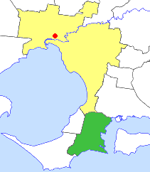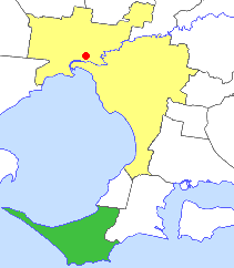
The Mornington Peninsula is a peninsula located south of Melbourne, Victoria, Australia. It is surrounded by Port Phillip to the west, Western Port to the east and Bass Strait to the south, and is connected to the mainland in the north. Geographically, the peninsula begins its protrusion from the mainland in the area between Pearcedale and an area north of Frankston. The area was originally home to the Mayone-bulluk and Boonwurrung-Balluk clans and formed part of the Boonwurrung nation's territory prior to European settlement.

Mornington Island, also known as Kunhanhaa, is an island in the Gulf of Carpentaria in the Shire of Mornington, Queensland, Australia. It is the northernmost and largest of 22 islands that form the Wellesley Islands group. The largest town, Gununa, is in the south-western part of the island.

The Wellesley Islands, also known as the North Wellesley Islands, is a group of islands off the coast of Far North Queensland, Australia, in the Gulf of Carpentaria. It is a locality within the Shire of Mornington local government area. The traditional owners of the islands are the Lardil people. In the 2016 census, the Wellesley Islands had a population of 1,136 people, all living on the largest island, Mornington Island.
Doomadgee is a town and a locality in the Aboriginal Shire of Doomadgee, Queensland, Australia. It is a mostly Indigenous community, situated about 140 kilometres (87 mi) from the Northern Territory border, and 93 kilometres (58 mi) west of Burketown.

The Shire of Mornington is a local government area in northwestern Queensland, Australia. The shire covers the Wellesley Islands, which includes Mornington Island; the South Wellesley Islands; Bountiful Islands; and West Wellesley / Forsyth Islands groups in the Gulf of Carpentaria.

Newbridge is a town in central Victoria, Australia. The town is located on the Loddon River and in the Shire of Loddon local government area, 173 kilometres (107 mi) north of the state capital, Melbourne. In the 2016 census, Newbridge had a population of 192.

The Shire of Hastings was a local government area about 60 kilometres (37 mi) south-southeast of Melbourne, the state capital of Victoria, Australia, encompassing the eastern extremity of the Mornington Peninsula. The shire covered an area of 304.6 square kilometres (117.6 sq mi), and existed from 1960 until 1994.

The Shire of Flinders was a local government area encompassing the extremity of the Mornington Peninsula, about 65 kilometres (40 mi) south of Melbourne, the state capital of Victoria, Australia. The shire covered an area of 324 square kilometres (125.1 sq mi), and existed from 1874 until 1994.

The Shire of Mornington was a local government area about 50 kilometres (30 mi) south of Melbourne, the state capital of Victoria, Australia, encompassing the western extremity of the Mornington Peninsula. The shire covered an area of 90.65 square kilometres (35.0 sq mi) immediately to the south of Frankston, and existed from 1860 until 1994.

The City of Frankston was a local government area about 40 kilometres (25 mi) south of Melbourne, the state capital of Victoria, Australia. The city covered an area of 70.96 square kilometres (27.4 sq mi) in and around Frankston, and existed from 1860 until 1994.

The Shire of Phillip Island was a local government area in Western Port Bay, about 120 kilometres (75 mi) south of Melbourne, the state capital of Victoria, Australia. The shire covered an area of 101.05 square kilometres (39.0 sq mi), and existed from 1928 until 1994.

The South Wellesley Islands is an island group and locality in the Gulf of Carpentaria within the Shire of Mornington, Queensland, Australia. The group is separate from the Wellesley Islands.
Gununa, sometimes spelt Gunana, is a rural town on Mornington Island within the locality of Wellesley Islands in the Shire of Mornington, Queensland, Australia. In the 2016 census, Gununa had a population of 1,136 people.

Sweers Island is an island in the South Wellesley Islands in the Gulf of Carpentaria, Queensland, Australia. Most of the island is Aboriginal Freehold Land, held in trust by the Kaiadilt Aboriginal Land Trust (KALT) on behalf of the traditional owners. There is a small private resort owned via a perpetual lease on Crown Land, being the site of a township dating from the 1800s, with the only residents being the owners and workers at the resort.
The Lardil people, who prefer to be known as Kunhanaamendaa, are an Aboriginal Australian people and the traditional custodians of Mornington Island in the Wellesley Islands chain in the Gulf of Carpentaria, Queensland.
The West Wellesley Islands, also referred to as the Forsyth Islands, is an island group and locality in the Gulf of Carpentaria within the Shire of Mornington, Queensland, Australia. The group lies to the south-west of the Wellesley Islands, closer to mainland Australia. The islands were uninhabited as of 2016.
Pains Island is one of the West Wellesley Islands, in Queensland's Gulf of Carpentaria, Australia. it is within the Shire of Mornington. It is located 4.83 km northwest of the mainland, and less than a kilometre north of Bayley Island.
Bentinck Island is one of the South Wellesley Islands, in Queensland's Gulf of Carpentaria. The traditional home of the Kaiadilt people, the island was the site of a brutal massacre in 1918 known as the McKenzie massacre, in which many Indigenous inhabitants died.


