Related Research Articles
Winn Parish is a parish located in the U.S. state of Louisiana. As of the 2020 census, the population was 13,755. The parish seat and largest city is Winnfield. The parish was founded in 1852. It is last in alphabetical order of Louisiana's sixty-four parishes. Winn is separated from Natchitoches Parish along U.S. Highway 71 by Saline Bayou, the first blackwater protected waterway in the American South.
St. John the Baptist Parish is a parish located in the U.S. state of Louisiana. At the 2020 census, the population was 42,477. The parish seat is Edgard, an unincorporated area, and the largest city is LaPlace, which is also unincorporated.
Avoyelles is a parish located in central eastern Louisiana on the Red River where it effectively becomes the Atchafalaya River and meets the Mississippi River. As of the 2020 census, the population was 39,693. The parish seat is Marksville. The parish was created in 1807, with the name deriving from the French name for the historic Avoyel people, one of the local Indian tribes at the time of European encounter.

Cottonport is a town in Avoyelles Parish, Louisiana, United States. The population was 2,006 at the 2010 census.

Evergreen is a town in Avoyelles Parish, Louisiana, United States. The population was 310 at the 2010 census. Evergreen is located east of Bunkie.

Marksville is a small city in and the parish seat of Avoyelles Parish, Louisiana, United States. The population was 5,702 at the 2010 census, an increase of 165 over the 2000 tabulation of 5,537.

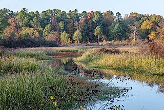
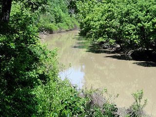
In usage in the Southern United States, a bayou is a body of water typically found in a flat, low-lying area. It may refer to an extremely slow-moving stream, river, marshy lake, wetland, or creek. They typically contain brackish water highly conducive to fish life and plankton. Bayous are commonly found in the Gulf Coast region of the southern United States, especially in the Mississippi River Delta, though they also exist elsewhere.

The Tensas River is a river in Louisiana in the United States. The river, known as Tensas Bayou in its upper reaches, begins in East Carroll Parish in the northeast corner of the state and runs roughly southwest for 177 miles (285 km) more or less in parallel with the Mississippi River. The confluence of the Tensas and the Ouachita rivers, in Jonesville in Catahoula Parish, creates the Black River, not to be confused with Black Lake in Natchitoches Parish in north-central Louisiana.

James Madison Wells was elected Lieutenant Governor and became the 20th Governor of Louisiana during Reconstruction.
Moncla is an unincorporated community village in Avoyelles Parish, Louisiana, United States. The population was 642 at the 2000 census.
Bayou Bartholomew is the longest bayou in the world, meandering approximately 364 miles (586 km) in the U.S. states of Arkansas and Louisiana.
Bayou Macon is a bayou in Arkansas and Louisiana. It begins in Desha County, Arkansas, and flows south, between the Boeuf River to its west and the Mississippi River to its east, before joining Joe's Bayou south of Delhi in Richland Parish, Louisiana. Bayou Macon is about 218 miles (351 km) long.

Ray's Ferry in Louisiana, United States, is the point along Bayou Boeuf in Avoyelles Parish, at which the road between Opelousas and Marksville crossed the waterway. A ferry service operated here from 1816. It is unknown how long the ferry was in service. The name comes from the individual, Reuben Ray, licensed to operate the ferry service. Ray was granted a permit from the State of Louisiana on September 19, 1816, to "keep a ferry across the Bayou Boeuf on the main road leading from Opelousas to Avoyelles". The permit can be inspected at the Court Archives of Saint Landry Parish, Courthouse, Opelousas, LA.

Louisiana Highway 106 is a state highway located primarily in Evangeline Parish that runs 24.2 miles (38.9 km) in a west–east direction from LA 10 east of Oakdale to LA 29 south of Bunkie. Along the way, LA 106 passes through the towns of Pine Prairie and St. Landry and intersects U.S. Highway 167. Near the east end of its route, LA 106 passes through an interchange with Interstate 49 (I-49) between Opelousas and Alexandria in the southwest corner of Avoyelles Parish.

Louisiana Highway 107 is a state highway located in central Louisiana that runs 65.0 miles (104.6 km) in a north–south direction from U.S. Highway 71 in Morrow to a junction with LA 1250 in Pineville at the Pineville Expressway. Along the way, LA 107 services Cottonport, Mansura, and Marksville, intersecting routes such as LA 29, LA 114, and LA 1. LA 107 has significant concurrencies with both LA 1 and LA 115 in the vicinity of Marksville.
Bordelonville is an unincorporated community and census-designated place (CDP) in Avoyelles Parish, Louisiana, United States. As of the 2010 census, it had a population of 525.
Terry, Louisiana is an unincorporated community in West Carroll Parish in the U.S. state of Louisiana. It is on Louisiana Highway 17 between Kilbourne and Oak Grove, on Tiger Bayou and Coleman Bayou watersheds.
Buck Mountain is a summit in the Free Union area of Albemarle County, Virginia. Its elevation is 1,358 feet and 414 meters. It was named for the abundance of deer in the area. Buck Mountain is bounded by 776, 667 and 601, and 671 roads, as well as Buck Mountain Creek.

Isle Brevelle is an ethnically and culturally diverse community, which began as a Native American and Louisiana Creole settlement and is located in Natchitoches Parish, Louisiana. For many years this area was known as Côte Joyeuse. It is considered the birthplace of Creole culture and remains the epicenter of Creole art and literature blending European, African, and Native American cultures. It is home to the Cane River Creole National Historical Park and part of the Louisiana African American Heritage Trail.

Edwin Epps House is a Creole cottage built in 1852 in part by Solomon Northup on Bayou Boeuf near Holmesville in Avoyelles Parish, Louisiana. It was built for Edwin Epps, a slaveholder. The house was a "double-sided, wood frame house with one chimney, and a tin roof" of mid-sized farmers. The Edwin Epps Plantation Site, where the house originally stood, is located off of LA 1176 on Carl Hunt Road. It is one of the historic sites of Solomon Northup's enslavement on the Northup Trail.
References
- ↑ "GNIS Detail - Bayou Huffpower". geonames.usgs.gov. Retrieved 2021-06-24.
- ↑ "Avoyelles Parish, Louisiana Rivers, Lakes & Streams". louisiana.msghn.org. Retrieved 2021-06-24.
- ↑ Bulletin United States Geological Survey - Number 194. Department of the Interior. 1902. p. 37.
- ↑ "Bayou Hoffpauir". geonames.usgs.gov. Retrieved 2021-06-24.
- ↑ Joiner, Gary D.; D, Professor of History Louisiana State University Gary D. Joiner, PH (2007). Little to Eat and Thin Mud to Drink: Letters, Diaries, and Memoirs from the Red River Campaigns, 1863-1864. Univ. of Tennessee Press. p. 168. ISBN 978-1-57233-571-4.
{{cite book}}: CS1 maint: multiple names: authors list (link)