Related Research Articles

East Stour is a village and civil parish in the ceremonial county of Dorset in southern England. It lies within the Dorset administrative district, about two miles south of the town of Gillingham. The village is 1⁄2 mile from the east bank of the River Stour in the Blackmore Vale and two miles west of the broadly conical local landmark Duncliffe Hill. Above the west bank of the river, about one mile away, is the village of West Stour. The A30 London to Penzance road passes through the village. In the 2011 census the civil parish had a population of 573.

North Dorset was a local government district in Dorset, England, between 1974 and 2019. Its area was largely rural, but included the towns of Blandford Forum, Gillingham, Shaftesbury, Stalbridge and Sturminster Newton. Much of North Dorset was in the River Stour valley, known as the Blackmore Vale. The economy of North Dorset was largely based on dairy agriculture.

Iwerne Courtney, also known as Shroton, is a village and civil parish in the English county of Dorset. It lies approximately 4 miles north-west of Blandford Forum. It is sited by the small River Iwerne between Hambledon Hill to the south-west and the hills of Cranborne Chase to the east. In 2001 the parish had 187 households and a population of 400. In 2013 the estimated population of the parish was 410.

Iwerne Minster is a village and civil parish in Dorset, England. It lies on the edge of the Blackmore Vale, approximately midway between the towns of Shaftesbury and Blandford Forum. The A350 main road between those towns passes through the edge of the village, just to the west. In the 2011 Census the civil parish had a population of 978.
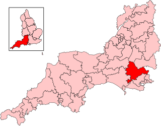
North Dorset is a constituency represented in the House of Commons of the UK Parliament since 2015 by Simon Hoare of the Conservative Party.

North Dorset District Council in Dorset, England existed from 1974 to 2019, when it was abolished and subsumed into Dorset Council.

Margaret Marsh is a hamlet and civil parish in north Dorset, England. It is situated in the Blackmore Vale, halfway between the towns of Shaftesbury and Sturminster Newton. It is sited on Kimmeridge Clay close to a small tributary stream of the River Stour. In the 2001 census the parish had a population of 60. In 2013 the estimated population of the parish was 40. The parish church has a 15th-century tower and 13th-century font, but the rest of the building was rebuilt in 1873. For local government purposes the parish is grouped with the parishes of East Orchard and West Orchard, to form a Group Parish Council.
Blackmore Vale is an electoral ward in Dorset. Since 2019, the ward has elected 1 councillor to Dorset Council.
Chalk Valleys is an electoral ward in Dorset. Since 2019, the ward has elected 1 councillor to Dorset Council.
Cranborne Chase is an electoral ward in Dorset. Since 2019, the ward has elected 1 councillor to Dorset Council.
Gillingham is an electoral ward in Dorset. Since 2019, the ward has elected 3 councillors to Dorset Council.
Lytchett Matravers and Upton is an electoral ward in Dorset. Since 2019, the ward has elected 3 councillors to Dorset Council.
Sherborne Rural is an electoral ward in Dorset. Since 2019, the ward has elected 1 councillor to Dorset Council.
Stour and Allen Vale is an electoral ward in Dorset. Since 2019, the ward has elected 1 councillor to Dorset Council.
Winterborne and Broadmayne is an electoral ward in Dorset. Since 2019, the ward has elected 1 councillor to Dorset Council.
References
- ↑ "Beacon (Ward, United Kingdom) - Population Statistics, Charts, Map and Location". www.citypopulation.de. Retrieved 2024-02-22.
- ↑ "Area profile for Beacon - Dorset Council". gi.dorsetcouncil.gov.uk. Retrieved 2024-02-24.
- ↑ "Map referred to in the Dorset (Electoral Changes) Order 2018" (PDF). Local Government Boundary Commission for England. 2018. Retrieved 3 August 2024.
- ↑ Dorset Council. "Results of the Dorset Council elections on 2 May 2024".
