
Ashmore is a village and civil parish in the North Dorset district of Dorset, England, situated 20 miles (32 km) south-west of Salisbury. The village is centred on a circular pond and consists of a church and several stone cottages and farms, many with thatched roofs. It is the highest village in the county. The pond or "mere" is what gave the village its original name of "Ashmere". In the 2011 census the parish had a population of 188.

Hilton is a village and civil parish in the county of Dorset in southern England. It is sited at an altitude of 135 metres in a small valley which drains chalk hills in the eastern part of the Dorset Downs, approximately 8 miles (13 km) west-south-west of the town of Blandford Forum. The summit of Bulbarrow Hill is 1.5 miles (2.4 km) north of the village. In the 2011 census the parish—which includes the settlement of Ansty to the west—had 231 dwellings, 206 households and a population of 477.

Iwerne Courtney, also known as Shroton, is a village and civil parish in the English county of Dorset. It lies within the North Dorset administrative district, approximately 4 miles (6 km) north-west of the town of Blandford Forum. It is sited by the small River Iwerne between Hambledon Hill to the south-west and the hills of Cranborne Chase to the east. In 2001 the parish had 187 households and a population of 400. In 2013 the estimated population of the parish was 410.

Iwerne Minster is a village and civil parish in Dorset, England. It lies on the edge of the Blackmore Vale, approximately midway between the towns of Shaftesbury and Blandford Forum. The A350 main road between those towns passes through the edge of the village, just to the west. In the 2011 Census the civil parish had a population of 978.

Alton Pancras is a small village and civil parish in Dorset, England. In the 2011 census the civil parish had a population of 175.

Cheselbourne is a village and civil parish in Dorset, England, situated in the Dorset Downs, 7 miles (11 km) north-east of Dorchester. The parish is at an altitude of 75 to 245 metres and covers an area of 1,175 hectares ; the underlying geology is chalk. In the 2011 census the parish had a population of 296.

Durweston is a village and civil parish in the English county of Dorset. It lies 2 miles (3.2 km) north-west of the town of Blandford Forum. It is sited by the River Stour at the point where it flows out of the Blackmore Vale through a steep, narrow gap between the Dorset Downs and Cranborne Chase. In the 2011 census the parish had a population of 398.
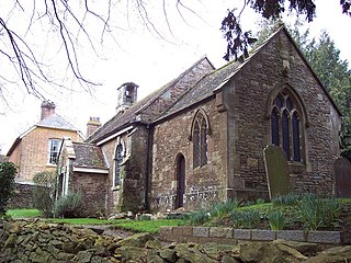
Fifehead Neville is a village and civil parish in the county of Dorset in southern England, situated in the Blackmore Vale about 2 miles (3.2 km) southwest of the town of Sturminster Newton. In the 2011 census the population of the parish was 147.

Fontmell Magna is a village and civil parish in north Dorset, England. It is situated in the Blackmore Vale, close to the chalk hills of Cranborne Chase, on the A350 road 5 miles (8 km) south of Shaftesbury and 8 miles (13 km) north of Blandford Forum. In the 2011 census the parish had a population of 734.

Mappowder is a village and civil parish in the county of Dorset in southern England. The parish lies approximately 9 miles (14 km) south-east of the town of Sherborne and covers about 1,900 acres (770 ha) at an altitude of 75 to 160 metres. It is sited on Corallian limestone soil at the southern edge of the Blackmore Vale, close to the northern scarp face of the Dorset Downs. In the 2011 census the parish had 71 dwellings, 69 households and a population of 166.

Milborne St Andrew is a village and civil parish in the county of Dorset in southern England. It is sited in a winterbourne valley on the dip slope of the Dorset Downs, on the A354 road 9 miles (14 km) northeast of the county town Dorchester. It lies in the North Dorset administrative district. In the 2011 census the parish had 472 dwellings, 453 households and a population of 1,062.

Stourpaine is a village and civil parish in the county of Dorset in southern England. It is situated in the valley of the River Stour in the North Dorset administrative district, 3 miles (4.8 km) northwest of Blandford Forum. The A350 road, which connects Blandford to Shaftesbury to the north, passes through the village. The chalk hills of Cranborne Chase and the Dorset Downs lie immediately to the north-east and south-west respectively. In the 2011 census the civil parish had 277 dwellings, 265 households and a population of 617.

Sutton Waldron is a village and civil parish in north Dorset, England, situated on the A350 road between Iwerne Minster and Fontmell Magna, in the Blackmore Vale under the scarp of Cranborne Chase, 8 miles (13 km) north of Blandford Forum and 5 miles (8.0 km) south of Shaftesbury. In the 2011 census the parish had 93 dwellings, 87 households and a population of 200.

Tarrant Gunville is a village and civil parish in north Dorset, England, situated at the head of the Tarrant Valley on Cranborne Chase 5 miles (8.0 km) northeast of Blandford Forum. The parish covers 3,469 acres (1,404 ha) at an altitude of 70 to 170 metres. In the 2011 census the parish—which includes the settlement of Stubhampton to the north—had 119 dwellings, 108 households and a population of 233.

Tarrant Keyneston is a village and civil parish in the English county of Dorset, situated in the Tarrant Valley 5 miles (8.0 km) southeast of Blandford Forum in the North Dorset administrative district. In the 2011 census the parish had 152 dwellings, 145 households and a population of 310.

Tarrant Monkton is a village and civil parish in north Dorset, England, situated in the Tarrant Valley about 4 miles (6.4 km) ENE of Blandford Forum. Within the parish boundary, sited 1.5 miles over hills to the west, lies the major part of Blandford Camp army base. In the 2011 census the parish—including the army base—had a population of 1,986. The village is centred on the All Saints Parish Church, opposite which is the Langton Arms, a public house and restaurant.

Winterborne Whitechurch, also Winterborne Whitchurch, is a village and civil parish in central Dorset, England, situated in a winterbourne valley on the A354 road on the Dorset Downs 5 miles (8.0 km) south-west of Blandford Forum. In the 2011 census the civil parish had 354 dwellings, 331 households and a population of 757.

Farnham is a village and civil parish in North Dorset, in the south of England, on Cranborne Chase, 7 miles (11 km) north east of Blandford Forum. In the 2011 census the parish had a population of 183.
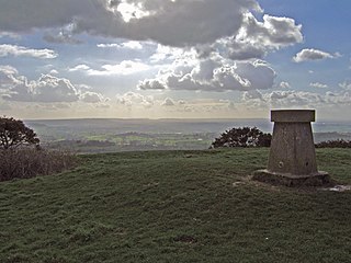
Melbury Hill, whose summit is also called Melbury Beacon, is a prominent hill, 263 metres high, on the high chalk escarpment of the North Dorset Downs above the village of Melbury Abbas in the county of Dorset in southern England.


