Related Research Articles

North Dorset was a local government district in Dorset, England. It was largely rural, but included the towns of Blandford Forum, Gillingham, Shaftesbury, Stalbridge and Sturminster Newton. Much of North Dorset was in the River Stour valley and is called the Blackmore Vale. The economy of North Dorset was largely dairy agriculture based.

Ashmore is a village and civil parish in the North Dorset district of Dorset, England, 20 miles southwest of Salisbury.

Iwerne Minster is a village and civil parish in Dorset, England. It lies on the edge of the Blackmore Vale, approximately midway between the towns of Shaftesbury and Blandford Forum. The A350 main road between those towns passes through the edge of the village, just to the west. In the 2011 Census the civil parish had a population of 978.

Melbury Abbas is a village and civil parish in north Dorset, England, 3 km SSW of the town of Shaftesbury, east of the A350 Shaftesbury to Blandford Forum road.

Fontmell Magna is a village and civil parish in north Dorset, England. It is situated in the Blackmore Vale, close to the chalk hills of Cranborne Chase, on the A350 road five miles south of Shaftesbury and eight miles north of Blandford Forum. In the 2011 census the parish had a population of 734.

Pentridge is a village and former civil parish, now in the parish of Sixpenny Handley and Pentridge, in the English county of Dorset, lying in the north-east of the county within the East Dorset administrative district. It is situated on the edge of Cranborne Chase down a dead-end minor lane just south of the A354 road between the towns of Blandford Forum and Salisbury. In 2001 it had a population of 215. The civil parish was abolished on 1 April 2015 and merged with Sixpenny Handley to form Sixpenny Handley and Pentridge.

Sixpenny Handley or Handley is a village and former civil parish, now in the parish of Sixpenny Handley and Pentridge, in north east Dorset, England, situated on Cranborne Chase ten miles (16 km) north east of Blandford Forum. In the 2011 census the parish had a population of 1,233. The civil parish was abolished on 1 April 2015 and merged with Pentridge to form Sixpenny Handley and Pentridge.

Sutton Waldron is a village and civil parish in north Dorset, England, situated on the A350 road between Iwerne Minster and Fontmell Magna, in the Blackmore Vale under the scarp of Cranborne Chase, 8 miles north of Blandford Forum and 5 miles south of Shaftesbury. In the 2011 census the parish had 93 dwellings, 87 households and a population of 200.
Cogdean Hundred was a hundred in the county of Dorset, England, containing the following parishes:
Eggerton Hundred or Eggardon Hundred was a hundred in the county of Dorset, England, containing the following parishes:
Redlane Hundred or Redland Hundred was a hundred in the county of Dorset, England, containing the following parishes:
Whiteway Hundred was a hundred in the English county of Dorset, containing the following parishes:
Cerne, Totcombe and Modbury Hundred was a hundred in the county of Dorset, England. Some of its tithings and parishes were exclaves which indicates that its ancient manors were likely the possessions of one related family who received them during the reign of William the Conqueror. The hundred contained the following parishes:
Sherborne Hundred was a hundred in the county of Dorset, England, containing the following parishes:
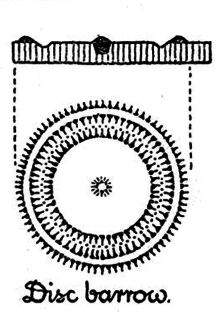
A disc barrow is a type of tumulus or round barrow, a variety of fancy barrow identified in English Heritage's Monument Class Descriptions.
References
- 1 2 3 Royal Commission on the Ancient and Historical Monuments and Constructions of England, (1975), An Inventory of Historical Monuments in the County of Dorset: East, page 64
- ↑ at 50°57′05″N2°13′26″W / 50.9514°N 2.2238°W
- ↑ Watts, Victor, ed. (2010), "Handley", The Cambridge Dictionary of English Place-Names, Cambridge University Press, ISBN 9780521168557
- ↑ Stuart Brookes; John Baker (2011). "A checklist for identifying early medieval meeting-places". p. 12. Retrieved 29 July 2018.