Winterborne Stickland

Last updated

Winterborne Stickland
Winterborne Stickland, Dorset, 2015.JPG
Winterborne Stickland
Dorset UK location map.svg
Red pog.svg
Winterborne Stickland
Location within Dorset
Population520 
OS grid reference ST835046
Unitary authority
Shire county
Region
Country England
Sovereign state United Kingdom
Post town Blandford Forum
Postcode district DT11
Police Dorset
Fire Dorset and Wiltshire
Ambulance South Western
UK Parliament
Website Winterborne Stickland Village Website
List of places
UK
England
Dorset
50°50′26″N2°14′07″W / 50.8405°N 2.2353°W / 50.8405; -2.2353

Winterborne Stickland is a village and civil parish in the county of Dorset in southern England. It lies about four miles (six kilometres) west of the town of Blandford Forum. In 2013 the civil parish had an estimated population of 520. [1] In the 2011 census the parish, combined with the smaller neighbouring parishes of Winterborne Clenston to the south and Turnworth to the north, recorded a population of 653. [2] For unknown reasons, the 1881 census listed 10 residents of Chorley, Lancashire as having been born in the village.

Contents

Winterborne Stickland is sited in a winterbourne valley in the Dorset Downs, which gives rise to the first part of its name. The second part "Stickland" is derived from sticol, Old English for "steep". [3]

Blandford Forest is a scattered area of woodlands northwest of Blandford Forum that is located within a 10 km radius of Winterborne Stickland.

History

The Domesday book [4] records the canons of Coutances (St Mary), Normandy, as the tenant-in-chief in 1066 with no change by 1086, after the conquest.

In the Pimperne Hundred, the village had 12 villagers, 20 smallholders, 5 slaves, 9 ploughlands, 4 lord's plough teams, 4 men's plough teams, 3.75 lord's lands, pasture of 26 by 4 furlongs (5,200 by 800 metres), woodland of 5 by 4 furlongs (1,000 by 800 metres) and 1 mill valued at 12 shillings and 5 pence.

The annual value to the lord was 15 pounds in 1086. The 37 households place Winterborne Stickland in the largest 20% of settlements recorded.

The Church

The parish Church of St Mary is a Grade I listed building. The nave and chancel date from the thirteenth century, the tower from around 1500 and the south porch from the sixteenth century. Restoration work took place in 1892. The building is constructed of bands of stone and flint and there is a north tomb chamber. The tower is on the west end and is in two stages; it has diagonal buttresses, pinnacles and a parapet surrounded by battlements. The interior is plastered and whitewashed and has a possibly medieval ribbed wagon roof. The font, hexagonal pulpit and the panelling in the tomb chamber are eighteenth century. The screen between the chancel and tomb chamber may use parts of the fifteenth century rood screen. There are various seventeenth, eighteenth and nineteenth century monuments, and the table tomb in the tomb chamber is dedicated to Thomas and Barbara Skinner. [5]

Amenities

To the north of the village is a children's playground, tennis court, football pitch and a clubhouse. The clubhouse is well known by locals for the 'Messy Games' which usually take place every summer and/or Christmas. In 2022, the children's playground was renovated with new wooden play equipment as the previous play equipment was too dangerous for use.

To the north of that is a small orchard of apple, pear and plum trees.

Many of the thatched cottages in the village are listed buildings. [6]

There is a pub in the centre of the village called The Crown. The Crown was extensively restored by Ray and Tina Clayton in 1983. At this point it was a free house.Now is currently owned by Ringwood Brewery. In 2019, Marstons Breweries tried to purchase the pub from Ringwood Brewery but they were unsuccessful in their attempt. As of March 2022, the pub has been renovated with a new sign and the pub has been painted blue. Due to the closure of Ringwood Brewery in 2023, The Crown is now independently owned.

The village used to have a post office which had a shop selling local food and other products. This closed down around 2015 and has since moved into the Pamela Hambro Hall. The former shop premises is currently owned by Valley Fabrications and is used to store various items.

There also used to be another village store in Winterborne Stickland known as Stickland Stores (later named Sticky Stores). It also closed down around the same time as the post office.

There is a MOT centre/garage in the village called 'Kevin's Garage' which used to sell petrol up until the late 1990s. This petrol station used to constantly change suppliers.

There also (allegedly) used to be another petrol station in the village opposite the former post office. It used to only have one pump and sold Shell branded fuel.

There is a village hall in the village called the Pamela Hambro Hall. This hall is used often by the community and is known for its Artsreach shows.

Just outside the village is a small area with four office blocks surrounded by a farm house.

There used to be a school in the village called 'The Dunbury School'. Unfortunately, the school closed its doors in 2011 and sat abandoned and empty for many years. It was originally going to be transferred into another primary school baring a different name but this never happened. Around 2013–2014, students at other Dunbury School bases decided to chose a name for the new nursery which would be in the old Stickland base. The name chosen was 'Stickleberries'. The new nursery opened in the old school premises around 2015-2016 and used to hold an after school club for Dunbury School students. The nursery is also surrounded by the village green. Stickberries was forced to close permanently in 2023 after safeguarding concerns from Ofsted. The fate of the former school/nursery site is currently unknown although it is likely to be converted into private housing.

The village green is a small area of greenery in Winterborne Stickland which contains the village sign, various benches and a river (the river Winterborne) flowing in the centre. The village sign was renovated and appeared in Season 2 Episode 7 of The Repair Shop in March 2018.

Governance

After 2019 structural changes to local government in England, Winterborne Stickland is part of the Winterborne North ward which elects 1 member to Dorset Council. [7]

Related Research Articles

<span class="mw-page-title-main">Blandford Forum</span> Market Town in Dorset, England

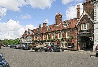
Blandford Forum is a market town in Dorset, England, by the River Stour 13 miles northwest of Poole. It had a population of 10,355 at the 2021 census.

<span class="mw-page-title-main">Ringwood, Hampshire</span> Town in Hampshire, England

Ringwood is a market town in south-west Hampshire, England, on the River Avon close to the New Forest, northeast of Bournemouth and southwest of Southampton. It was founded by the Anglo-Saxons, and has held a weekly market since the Middle Ages.

<span class="mw-page-title-main">Pewsey</span> Village and civil parish in Wiltshire, England

Pewsey is a large village and civil parish at the centre of the Vale of Pewsey in Wiltshire, about 6 miles (10 km) south of Marlborough and 71 miles (114 km) west of London. It is within reach of the M4 motorway and the A303 and is served by Pewsey railway station on the Reading to Taunton line.

<span class="mw-page-title-main">Milton Abbas</span> Human settlement in England

Milton Abbas is a village and civil parish in Dorset, England, lying around 5 miles southwest of Blandford Forum. In the 2011 Census the civil parish had a population of 755.

<span class="mw-page-title-main">Corfe Mullen</span> Human settlement in England

Corfe Mullen is a village in Dorset, England, on the north-western urban fringe of the South East Dorset conurbation. The community had a population of 10,133 at the 2011 Census. It is served by six churches, four pubs, five schools, a library, various shops and local businesses, a village hall, and many community and sports organisations. On 10 December 2019 The Corfe Mullen Parish Council resolved to adopt Town Council status, citing potential financial benefits. In all other aspects Corfe Mullen is still very much a village, albeit a large one.

<span class="mw-page-title-main">Chaldon Herring</span> Village in Dorset, England

Chaldon Herring or East Chaldon is a village and civil parish in the English county of Dorset, about 8 miles (13 km) south-east of the county town of Dorchester. It is sited 2 miles (3.2 km) from the coast in the chalk hills of the South Dorset Downs. The highest point in the area is Chaldon Hill about 1.5 miles (2.4 km) to the south, overlooking the sea. In the 2011 census the civil parish had 59 households and a population of 140.

<span class="mw-page-title-main">Milborne St Andrew</span> Village in Dorset, England

Milborne St Andrew is a village and civil parish in the county of Dorset in southern England. It is situated on the A354 road, 9 miles northeast of the county town Dorchester, in a winterbourne valley on the dip slope of the Dorset Downs. In the 2011 census the parish had 472 dwellings, 453 households and a population of 1,062.

<span class="mw-page-title-main">Winterborne Houghton</span> Village in Dorset, England

Winterborne Houghton is a village and civil parish in north Dorset, England. It is situated in a winterbourne valley on the Dorset Downs, five miles southwest of Blandford Forum. In the 2011 census the parish had 82 households and a population of 183. In 2001 the population was 195.

<span class="mw-page-title-main">Winterborne Kingston</span> Village in Dorset, England

Winterborne Kingston is a village and civil parish in the county of Dorset in southern England. It lies 7 miles south of the town of Blandford Forum and 2 mi (3 km) northeast of the large village of Bere Regis. It is situated in a winterbourne valley on the edge of the dip slope of the Dorset Downs. In the 2011 census the parish had 282 households and a population of 643. In 2001 it had a population of 613.

<span class="mw-page-title-main">Winterborne Whitechurch</span> Human settlement in England

Winterborne Whitechurch is a village and civil parish in central Dorset, England, situated in a winterbourne valley on the A354 road on the Dorset Downs five miles southwest of Blandford Forum. In the 2011 census the civil parish had 354 dwellings, 331 households and a population of 757.

<span class="mw-page-title-main">Winterborne Zelston</span> Human settlement in England

Winterborne Zelston is a village and civil parish in north Dorset, England. It is situated in a winterbourne valley on the A31 road eight miles south of Blandford Forum and 10 mi (16 km) northwest of Poole. The parish had a population of 141 in 2001. In 2013 the estimated population of the civil parish was 90.

<span class="mw-page-title-main">Great Alne</span> Human settlement in England

Great Alne is a small village in Warwickshire, England, 7 miles (11 km) north-west of Stratford-upon-Avon, 3 miles (4.8 km) north-east of Alcester and 15 miles (24 km) from Warwick, on the road to Wootton Wawen. It takes its name from the River Alne and was first chronicled in the charter of King Ethelbald (723–737). In 1969 Warwickshire County Council designated part of Great Alne as a Conservation Area, including most of the village east of the Memorial Hall and twelve listed buildings of local architectural and historical value. At the 2001 Census the population was 587.

<span class="mw-page-title-main">Tittleshall</span> Human settlement in England

Tittleshall is a village and civil parish in the English county of Norfolk.

<span class="mw-page-title-main">Spernall</span> Human settlement in England

Spernall is a remote village 4 miles (6.4 km) north of Alcester in the parish of Oldberrow, Morton Bagot, and Spernall, in the Stratford-on-Avon District of Warwickshire, England. In the 2001 Census it had a population of 153. It is situated on the banks of the small River Arrow, the name meaning Spera's border. Early forms of the name are Spernore. and Spernoure in the 1327 Subsidy Roll. The village consists only of the church and rectory and a few scattered farms and cottages. At some time between 1195 and 1361 the parish was largely depopulated by pestilence, so that many of the villein tenements, which had hitherto accounted for almost the whole population, came into the hands of freemen. This may well refer to the Black Death; the priest at Spernall, Nicholas atte Yate, died in 1349 and there was another institution in 1351. In the 17th century the population seems to have mainly consisted of substantial farmers, for in 1625 it is described as a place with 'few or no poor at all in it and many wealthy inhabitants', and the Hearth Tax returns (1662–74) show the high average of about 2.5 hearths per house. By 1696, there were only two yeomen with an estate of £10 a year or more.

<span class="mw-page-title-main">Honing, Norfolk</span> Village in Norfolk, England

Honing is a village and a civil parish in the English county of Norfolk. The village is 15 miles (24 km) north-northeast of Norwich, 13 miles (21 km) south east of Cromer and 4 miles (6.4 km) east of North Walsham.

<span class="mw-page-title-main">Hammoon</span> Village in Dorset, England

Hammoon is a small village and civil parish in the English county of Dorset, sited on a river terrace of alluvial silt by the River Stour, about two miles east of the small town of Sturminster Newton. Its name is derived from the Old English ham, meaning dwelling, and the surname of the Norman lord of the manor. In 2001 the parish had 19 households and a population of 49. In 2013 the estimated population of the parish was 40.

<span class="mw-page-title-main">Winterborne Clenston</span> Human settlement in England

Winterborne Clenston is a small village and civil parish in Dorset, England, around 3+12 miles southwest of Blandford Forum. In 2013 the civil parish had an estimated population of 40.

References

  1. "Parish Population Data". Dorset County Council. 20 January 2015. Retrieved 8 February 2015.
  2. "Neighbourhood Statistics. Area: Winterborne Stickland (Parish). Key Figures for 2011 Census: Key Statistics". Office for National Statistics. Retrieved 18 November 2013.
  3. Roland Gant (1980). Dorset Villages. Robert Hale Ltd. p. 78. ISBN   0 7091 8135 3.
  4. "Domesday Book". opendomesday.org. Retrieved 25 March 2020.
  5. "Church of St Mary, Winterborne Stickland". British Listed Buildings. Retrieved 26 August 2016.
  6. "Listed Buildings in Winterborne Stickland, Dorset, England". British Listed Buildings. Retrieved 26 August 2016.
  7. "Area profile for Winterborne North - Dorset Council". gi.dorsetcouncil.gov.uk. Retrieved 24 February 2024.