Fifehead Neville

Last updated

Fifehead Neville
All Saints Church, Fifehead Neville - geograph.org.uk - 336392.jpg
All Saints Church
Dorset UK location map.svg
Red pog.svg
Fifehead Neville
Location within Dorset
Population147  [1]
OS grid reference ST766109
Unitary authority
Shire county
Region
Country England
Sovereign state United Kingdom
Post town Sturminster Newton
Postcode district DT10
Police Dorset
Fire Dorset and Wiltshire
Ambulance South Western
UK Parliament
List of places
UK
England
Dorset
50°53′51″N2°19′51″W / 50.8976°N 2.3307°W / 50.8976; -2.3307
Packhorse bridge over the River Divelish Footbridge over the River Divelish - geograph.org.uk - 336344.jpg
Packhorse bridge over the River Divelish

Fifehead Neville is a village and civil parish in the county of Dorset in southern England, situated in the Blackmore Vale about two miles (three kilometres) southwest of the town of Sturminster Newton. In the 2011 census the population of the parish was 147. [1]

Contents

Toponymy

The first part of the name Fifehead Neville derives from the Old English fīf and hīd, meaning '(estate of) five hides of land'. It was recorded as Fifhide in the Domesday Book of 1086. The second part derives from the de Neville family who were here in the 13th century; in 1287 the name Fyfhud Neuyle was recorded. [2] This differentiated this Fifehead from other Dorset manorial holdings called Fifehead (Fifehead St Quintin and Fifehead St Magdalen).
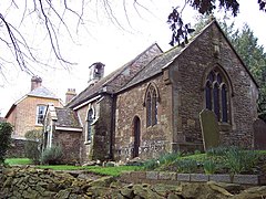
History

In a field bordering the River Divelish the remains of two wings of a Roman villa were found in 1880 and 1903. Floor mosaics and part of a hypocaust system were uncovered. [3] The archaeological findings are on view in the Dorset Museum in Dorchester.

The Domesday Book records that in 1086 the estate of Fifehead Neville had eight households and was part of Pimperne Hundred. [4] The tenant-in-chief of the estate was Waleran the Hunter whose tenant was Ingelrann. [4] [5] The overlordship descended to Walter Walerand (d. 1200–1) and to his daughter and co-heiress Isabel de Waleran who married William de Nevill. The overlordship was inherited by Isabel de Nevill's daughter Joan de Nevill (d. 1263), wife of Jordan de St. Martin. [5]

Crossing the Divelish is an old packhorse bridge [3] that has two pointed arches and is probably medieval. [6]

Before 1920 the parish was in two parts, each with its own settlement—Fifehead Neville in the north and Lower Fifehead or Fifehead St Quentin in the south. It is probable each settlement had previously had its own open field system. [6] Fifehead St Quentin (or Fifehead St Quintin) [7] was previously a detached part of Belchalwell, [6] a former parish that is now part of the parish of Okeford Fitzpaine.

Geography

Fifehead Neville parish is in the North Dorset administrative district in the Blackmore Vale, sited next to the River Divelish which drains land north of the Dorset Downs around Bulbarrow Hill. The parish, which covers 1,350 acres (550 hectares) at an elevation of 60 to 90 metres (200 to 300 feet), is also drained by a small tributary of the River Lydden in the west. [6] The underlying geology is mostly Corallian Limestone, with a small amount of Kimmeridge clay in the east and some Oxford clay at Deadmoor Common in the west. [6] [8] Measured directly, Fifehead Neville village is about 2 mi (3 km) SW of Sturminster Newton, 8 mi (13 km) NNW of Blandford Forum and 14 mi (23 km) NNE of the county town, Dorchester. [9]

Demography

In the 2011 census Fifehead Neville civil parish had 61 dwellings, [10] 56 households and a population of 147. [1]

The population of the parish in the censuses between 1921 and 2001 is shown in the table below:

Census Population of Fifehead Neville Parish 1921—2001 (except 1941)
Census19211931195119611971198119912001
Population133145153149140160120140
Source:Dorset County Council [11]

In 2013 the estimated population of the parish was 180. [12]

Related Research Articles

<span class="mw-page-title-main">Stalbridge</span> Human settlement in England

Stalbridge is a town and civil parish in Dorset, England, situated in the Blackmore Vale, near the border with Somerset. In the 2011 census the civil parish—which includes the hamlets of Stalbridge Weston, and Thornhill—had 1,160 households and a population of 2,698. The nearest towns are Sturminster Newton, four miles southeast, Sherborne, 6 mi (10 km) west, and Shaftesbury, 7 mi (11 km) northeast. Stalbridge is situated on the A357 on a low limestone ridge, one mile west of the River Stour. It officially became a town in April 1992.

<span class="mw-page-title-main">Sturminster Newton</span> Human settlement in England

Sturminster Newton is a town and civil parish in the Blackmore Vale area of Dorset, England. It is situated on a low limestone ridge in a meander of the River Stour. The town is at the centre of a large dairy agriculture region, around which the town's economy is built. The larger part of the town (Sturminster) lies on the north side of the river, and includes most shops and services, whilst to the south is the smaller Newton.

<span class="mw-page-title-main">North Dorset</span> Former non-metropolitan district in England

North Dorset was a local government district in Dorset, England, between 1974 and 2019. Its area was largely rural, but included the towns of Blandford Forum, Gillingham, Shaftesbury, Stalbridge and Sturminster Newton. Much of North Dorset was in the River Stour valley, known as the Blackmore Vale. The economy of North Dorset was largely based on dairy agriculture.

<span class="mw-page-title-main">Maiden Newton</span> Village in Dorset, England

Maiden Newton is a village and civil parish in the county of Dorset in south-west England. It lies within the Dorset Council administrative area, about 9 miles (14 km) north-west of the county town, Dorchester.

<span class="mw-page-title-main">Marnhull</span> Human settlement in England

Marnhull is a village and civil parish in the county of Dorset in southern England. It lies in the Blackmore Vale, three miles north of Sturminster Newton. The resort towns of Bournemouth and Weymouth are approximately 30 miles south. Marnhull is sited on a low ridge of Corallian limestone above the valley of the River Stour, which forms the northern and western boundaries of the parish. In the 2011 census the parish had 962 dwellings, 905 households and a population of 1,998.

<span class="mw-page-title-main">Shillingstone</span> Human settlement in England

Shillingstone is a village and civil parish in the Blackmore Vale area of north Dorset, England, situated on the River Stour between Sturminster Newton and Blandford Forum. In the 2011 Census the civil parish had 479 households and a population of 1,170.

<span class="mw-page-title-main">Stourton Caundle</span> Human settlement in England

Stourton Caundle is a village and civil parish in the county of Dorset in southwest England. It lies within the Blackmore Vale, about five miles east of Sherborne. In the 2011 census the parish had 181 households and a population of 439.

<span class="mw-page-title-main">Durweston</span> Human settlement in England

Durweston is a village and civil parish in the English county of Dorset. It lies two miles northwest of the town of Blandford Forum. It is sited by the River Stour at the point where it flows out of the Blackmore Vale through a steep, narrow gap between the Dorset Downs and Cranborne Chase. In the 2011 census the parish had a population of 398.

<span class="mw-page-title-main">Folke</span> Parish in Dorset, England

Folke is a parish in the county of Dorset in southern England, situated in the Blackmore Vale, approximately 3.5 miles (5.6 km) south-east of Sherborne. The parish has an area of 2,120 acres (8.6 km2) and is made of the villages of Folke and Alweston, and the hamlet of Bishops Down. Dorset County Council's 2013 estimate of the population of Folke parish is 270. In the 2011 census figures have been published for the population of Folke parish combined with the small parish of North Wootton to the north; this was 339.

<span class="mw-page-title-main">Ibberton</span> Human settlement in England

Ibberton is a village and civil parish in the county of Dorset in southern England. It is situated in the Blackmore Vale under the scarp face of the Dorset Downs, five miles south of Sturminster Newton and 7 miles west of Blandford Forum. The parish covers 1,382 acres extending over the chalk downs that lie to the south and includes the hamlets of Leigh, and Kitford. In the 2011 census the parish had a population of 101, a reduction from 134 in 2001.

<span class="mw-page-title-main">Lydlinch</span> Human settlement in England

Lydlinch is a village and civil parish in the Blackmore Vale in north Dorset, England, about three miles west of Sturminster Newton. The village is sited on Oxford clay close to the small River Lydden. The parish – which includes the village of King's Stag to the south and the hamlet of Stock Gaylard to the west – is bounded by the Lydden to the east and its tributary, the Caundle Brook, to the north.

<span class="mw-page-title-main">Manston, Dorset</span> Human settlement in England

Manston is a small village and civil parish in the county of Dorset in southern England, lying next to the River Stour in the Blackmore Vale, two miles east of Sturminster Newton. The geology of the parish consists mostly of Kimmeridge clay, with a thin strip of Corallian limestone in the west.

<span class="mw-page-title-main">Okeford Fitzpaine</span> Village and civil parish in Dorset, England

Okeford Fitzpaine is a village and civil parish in the English county of Dorset, situated in the Blackmore Vale three miles south of the town of Sturminster Newton. It is sited on a thin strip of greensand under the scarp face of the Dorset Downs. In the 2011 census the civil parish—which includes the village of Belchalwell to the west and most of the hamlet of Fiddleford to the north—had 404 dwellings, 380 households and a population of 913.

<span class="mw-page-title-main">Sutton Waldron</span> Human settlement in England

Sutton Waldron is a village and civil parish in north Dorset, England, situated on the A350 road between Iwerne Minster and Fontmell Magna, in the Blackmore Vale under the scarp of Cranborne Chase, 8 miles north of Blandford Forum and 5 miles south of Shaftesbury. In the 2011 census the parish had 93 dwellings, 87 households and a population of 200.

<span class="mw-page-title-main">Belchalwell</span> Village in Dorset, England

Belchalwell is a small village and former civil parish, now in the parish of Okeford Fitzpaine in the Blackmore Vale, in the Dorset district, in the ceremonial county of Dorset, England. It lies 2+12 miles south of Sturminster Newton and 6 miles northwest of Blandford Forum. Belchalwell Street is sited on Upper Greensand, with Lower Belchalwell on the boundary of Gault and Kimmeridge Clay, both beneath the north slopes of Bell Hill, part of the Dorset Downs. In 1881 the parish had a population of 169. On 25 March 1885 the parish was abolished and merged with Okeford Fitzpaine and Fifehead Neville.

<span class="mw-page-title-main">Hazelbury Bryan</span> Village in Dorset, England

Hazelbury Bryan is a village and civil parish in the county of Dorset in southern England. It is situated in the Blackmore Vale, approximately five miles southwest of the small town of Sturminster Newton. The parish includes the hamlets of Droop, Kingston, Parkgate, Pidney, Pleck, Wonston and Woodrow. In the 2011 census the parish had 480 dwellings, 454 households and a population of 1,059.

<span class="mw-page-title-main">Hammoon</span> Village in Dorset, England

Hammoon is a small village and civil parish in the English county of Dorset, sited on a river terrace of alluvial silt by the River Stour, about two miles east of the small town of Sturminster Newton. Its name is derived from the Old English ham, meaning dwelling, and the surname of the Norman lord of the manor. In 2001 the parish had 19 households and a population of 49. In 2013 the estimated population of the parish was 40.

References

  1. 1 2 3 "Area: Fifehead Neville (Parish), Key Figures for 2011 Census: Key Statistics". Neighbourhood Statistics. Office for National Statistics . Retrieved 16 July 2014.
  2. David Mills, ed. (2011). A Dictionary of British Place Names. Oxford University Press. p. 188. ISBN   978-0-19-960908-6.
  3. 1 2 North Dorset District Council (c. 1982). North Dorset District Official Guide. Home Publishing Co. Ltd. p. 33.
  4. 1 2 "Place: Fifehead [Neville]". Open Domesday. domesdaymap.co.uk. Archived from the original on 25 July 2014. Retrieved 18 July 2014.
  5. 1 2 Victoria County History, A History of the County of Wiltshire, volumes 4, 11, 12, 15, A History of the County of Dorset, volume 3
  6. 1 2 3 4 5 "'Fifehead Neville', An Inventory of the Historical Monuments in Dorset, Volume 3: Central (1970), pp. 92–94". British History Online. University of London & History of Parliament Trust. November 2013. Retrieved 16 July 2014.
  7. Ordnance Survey (1985), 1:25,000 Pathfinder Series, Sheet ST 61/71 Sherborne and Sturminster Newton
  8. Ralph Wightman (1983). Portrait of Dorset (4 ed.). Robert Hale Ltd. p. 17. ISBN   0-7090-0844-9.
  9. John Bartholomew & Son Ltd. (1980), 1:100,000 National Map Series, Sheet 4 (Dorset), ISBN   0-7028-0327-8
  10. "Area: Fifehead Neville (Parish), Dwellings, Household Spaces and Accommodation Type, 2011 (KS401EW)". Neighbourhood Statistics. Office for National Statistics. Retrieved 21 July 2014.
  11. "Parishes (A-L), 1921-2001- Census Years". Dorset County Council. 27 May 2014. Retrieved 21 July 2014.
  12. "Parish Population Data". Dorset County Council. 20 January 2015. Retrieved 20 January 2015.

Commons-logo.svg Media related to Fifehead Neville at Wikimedia Commons