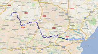
The River Stour is a river in East Anglia, England. It is 47 miles (76 km) long and forms most of the county boundary between Suffolk to the north, and Essex to the south. It rises in eastern Cambridgeshire, passes to the east of Haverhill, through Cavendish, Bures, Sudbury, Nayland, Stratford St Mary, Dedham and flows through the Dedham Vale Area of Outstanding Natural Beauty. It becomes tidal just before Manningtree in Essex and joins the North Sea at Harwich.
The River Stour is a 61 mi (98 km) river which flows through Wiltshire and Dorset in southern England, and drains into the English Channel. The catchment area for the river and its tributaries is listed as being 480 square miles (1,240 km2).

The Stour is a river flowing through the counties of Worcestershire, the West Midlands and Staffordshire in the West Midlands region of England. The Stour is a major tributary of the River Severn, and it is about 25 miles (40 km) in length. It has played a considerable part in the economic history of the region.

North Dorset was a local government district in Dorset, England. It was largely rural, but included the towns of Blandford Forum, Gillingham, Shaftesbury, Stalbridge and Sturminster Newton. Much of North Dorset was in the River Stour valley and is called the Blackmore Vale. The economy of North Dorset was largely dairy agriculture based.
A bigram or digram is a sequence of two adjacent elements from a string of tokens, which are typically letters, syllables, or words. A bigram is an n-gram for n=2. The frequency distribution of every bigram in a string is commonly used for simple statistical analysis of text in many applications, including in computational linguistics, cryptography, speech recognition, and so on.

Sturminster Marshall is a village and civil parish in east Dorset in England, situated on the River Stour between Blandford Forum and Poole. The parish had a population of 1,895 at the 2001 census, increasing to 1,969 at the 2011 Census and includes the village of Almer west of Sturminster Marshall, near Winterborne Zelston and the hamlet of Henbury to the south-east of the village. The village is twinned with the French commune of Sainte-Mère-Église in Normandy. The appropriate electoral ward is called 'Stour'. From Sturminster Marshall the ward goes east to Pamphill, with a total population of 2,582.
The Wantsum Channel was a strait separating the Isle of Thanet from the north-eastern extremity of the English county of Kent and connecting the English Channel and the Thames Estuary. It was a major shipping route when Britain was part of the Roman Empire, and continued in use until it was closed by silting in the late Middle Ages. Its course is now represented by the River Stour and the River Wantsum, which is little more than a drainage ditch lying between Reculver and St Nicholas-at-Wade and joins the Stour about 1.7 miles (2.7 km) south-east of Sarre.

The Moors River is a river in east Dorset, England, which starts at the point where the River Crane and the Ebblake Stream meet, at Ebblake, south of Verwood.

European route E22 is one of the longest European routes. It has a length of about 5,320 km (3,310 mi). Many of the E-roads have been extended into Asia since the year 2000; the E22 was extended on 24 June 2002.

Fiddleford Manor is a medieval manor house located near Sturminster Newton, Dorset. It is thought to have been originally built around 1370 for William Latimer, the sheriff of Somerset and Dorset, after the manor passed to him in 1355. The house is now owned by English Heritage and open for the public to visit throughout the year; however, there is an adjoining building to the north that continues to serve as a private residence and is not open to the public.
Westover, Hampshire, is the ancient manor, now in Dorset, over which much of modern Bournemouth has developed. This area of land marked a historic boundary between Celtic and Saxon civilisations, which found expression as the county boundary between Hampshire to the east and Dorset to the west. Geographically detached parts of the manor may have resulted from the post-Civil War breakup of estates formerly belonging to the Lords Arundell of Wardour.
Whitchurch is a parish and a small hamlet lying on the left bank of the River Stour in Warwickshire, England, some four miles south-south-east of the town of Stratford-upon-Avon.

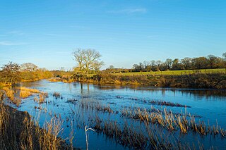
The River Stour has been used for centuries as a source of power. Many different processes were performed by the use of water power:- Corn milling, fulling, paper making and electricity generation. Many of the mills survive today as house conversions, with two of them still working commercially.

Preston on Stour is a village and civil parish in Warwickshire, England.

Hammoon is a small village and civil parish in the English county of Dorset, sited on a river terrace of alluvial silt by the River Stour, about two miles east of the small town of Sturminster Newton. Its name is derived from the Old English ham, meaning dwelling, and the surname of the Norman lord of the manor. In 2001 the parish had 19 households and a population of 49. In 2013 the estimated population of the parish was 40.
The Rolling River First Nation is a First Nations community in Manitoba, located south of Riding Mountain National Park.

The River Winterborne is a river in Dorset, England.

Dorset is a county located in the middle of the south coast of England. It lies between the latitudes 50.512°N and 51.081°N and the longitudes 1.682°W and 2.958°W, and occupies an area of 2,653 km2. It spans 90 kilometres (56 mi) from east to west and 63 kilometres (39 mi) from north to south.

The English River Dene Nation is a Dene First Nation band government in Patuanak, Saskatchewan, Canada. Their reserve is in the northern section of this Canadian province. Its territories are in the boreal forest of the Canadian Shield. This First Nation is a member of the Meadow Lake Tribal Council (MLTC).
Northbourne is a suburb of Bournemouth, Dorset in England. It is in the north of the town and borders Ensbury Park.
