Coordinates: 50°52′57″N2°08′04″W / 50.8825°N 2.1345°W Pimperne Hundred was a hundred in the county of Dorset, England, containing the following parishes:

A geographic coordinate system is a coordinate system that enables every location on Earth to be specified by a set of numbers, letters or symbols. The coordinates are often chosen such that one of the numbers represents a vertical position and two or three of the numbers represent a horizontal position; alternatively, a geographic position may be expressed in a combined three-dimensional Cartesian vector. A common choice of coordinates is latitude, longitude and elevation. To specify a location on a plane requires a map projection.

A county is a geographical region of a country used for administrative or other purposes, in certain modern nations. The term is derived from the Old French conté or cunté denoting a jurisdiction under the sovereignty of a count (earl) or a viscount. The modern French is comté, and its equivalents in other languages are contea, contado, comtat, condado, Grafschaft, graafschap, Gau, etc..

Dorset is a county in South West England on the English Channel coast. The ceremonial county comprises the unitary authority areas of Bournemouth, Christchurch and Poole and Dorset. Covering an area of 2,653 square kilometres (1,024 sq mi), Dorset borders Devon to the west, Somerset to the north-west, Wiltshire to the north-east, and Hampshire to the east. The county town is Dorchester which is in the south. After the reorganisation of local government in 1974 the county's border was extended eastward to incorporate the Hampshire towns of Bournemouth and Christchurch. Around half of the population lives in the South East Dorset conurbation, while the rest of the county is largely rural with a low population density.
- Bryanston
- Durweston
- Fifehead Neville
- Hammoon
- Hazelbury Bryan
- Iwerne Stepleton
- Langton Long Blandford
- Pimperne
- Stourpaine
- Tarrant Hinton
- Tarrant Keyneston
- Tarrant Launceston
- Tarrant Rawston
- Winterborne Houghton
- Winterborne Stickland
Bryanston is a village and civil parish in north Dorset, England, situated on the River Stour 1 mile (1.6 km) west of Blandford Forum. In the 2011 census the parish had a population of 925. The village is adjacent to the grounds of Bryanston School, an independent school.

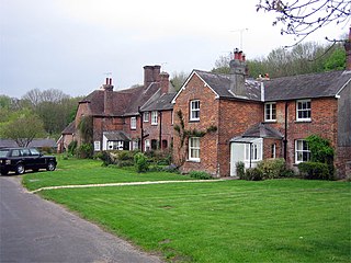
Durweston is a village and civil parish in the English county of Dorset. It lies within the North Dorset administrative district, 2 miles (3.2 km) north-west of the town of Blandford Forum. It is sited by the River Stour at the point where it flows out of the Blackmore Vale through a steep, narrow gap between the Dorset Downs and Cranborne Chase. In the 2011 census the parish had a population of 398.
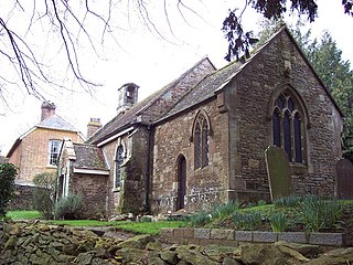
Fifehead Neville is a village and civil parish in the county of Dorset in southern England, situated in the Blackmore Vale about 2 miles (3.2 km) southwest of the town of Sturminster Newton in the North Dorset administrative district. In the 2011 census the population of the parish was 147.
