
Wayne County is a county located in the U.S. state of North Carolina. As of the 2010 Census, the population was 122,623. Its county seat is Goldsboro and it is home to Seymour Johnson Air Force Base.

Goldsboro, originally Goldsborough, is a city in Wayne County, North Carolina, United States. The population was 36,437 at the 2010 Census. It is the principal city of and is included in the Goldsboro, North Carolina Metropolitan Statistical Area. The nearby town of Waynesboro was founded in 1787, and Goldsboro was incorporated in 1847. It is the county seat of Wayne County. The city is situated in North Carolina's Coastal Plain and is bordered on the south by the Neuse River and the west by the Little River, about 40 miles (64 km) southwest of Greenville, 50 miles (80 km) southeast of Raleigh, the state capital, and 75 miles (121 km) north of Wilmington in Southeastern North Carolina. Seymour Johnson Air Force Base is located in Goldsboro.
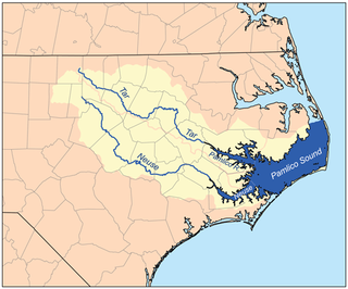
The Neuse River is a river rising in the Piedmont of North Carolina and emptying into Pamlico Sound below New Bern. Its total length is approximately 275 miles (443 km), making it the longest river entirely contained in North Carolina. The Trent River joins the Neuse at New Bern. Its drainage basin, measuring 5,630 square miles (14,600 km2) in area, also lies entirely inside North Carolina. It is formed by the confluence of the Flat and Eno rivers prior to entering the Falls Lake reservoir in northern Wake County. Its fall line shoals, known as the Falls of the Neuse, lie submerged under the waters of Falls Lake.

The Santa Ana River is the largest river entirely within Southern California in the United States. It rises in the San Bernardino Mountains and flows for most of its length through San Bernardino and Riverside Counties, before cutting through the northern Santa Ana Mountains via Santa Ana Canyon and flowing southwest through urban Orange County to drain into the Pacific Ocean. The Santa Ana River is 96 miles (154 km) long, and its drainage basin is 2,650 square miles (6,900 km2) in size.

The Feather River is the principal tributary of the Sacramento River, in the Sacramento Valley of Northern California. The river's main stem is about 73 miles (117 km) long. Its length to its most distant headwater tributary is just over 210 miles (340 km). The main stem Feather River begins in Lake Oroville, where its four long tributary forks join together—the South Fork, Middle Fork, North Fork, and West Branch Feather Rivers. These and other tributaries drain part of the northern Sierra Nevada, and the extreme southern Cascades, as well as a small portion of the Sacramento Valley. The total drainage basin is about 6,200 square miles (16,000 km2), with approximately 3,604 square miles (9,330 km2) above Lake Oroville.
The River Rouge is a 127-mile river in the Metro Detroit area of southeastern Michigan. It flows into the Detroit River at Zug Island, which is the boundary between the cities of River Rouge and Detroit.

The Mokelumne River is a 95-mile (153 km)-long river in northern California in the United States. The river flows west from a rugged portion of the central Sierra Nevada into the Central Valley and ultimately the Sacramento–San Joaquin River Delta, where it empties into the San Joaquin River-Stockton Deepwater Shipping Channel. Together with its main tributary, the Cosumnes River, the Mokelumne drains 2,143 square miles (5,550 km2) in parts of five California counties. Measured to its farthest source at the head of the North Fork, the river stretches for 157 miles (253 km).

The Conestoga River, also referred to as Conestoga Creek, is a 61.6-mile-long (99.1 km) tributary of the Susquehanna River flowing through the center of Lancaster County, Pennsylvania, United States.

The Blue Earth River is a tributary of the Minnesota River, 108 miles (174 km) long, in southern Minnesota in the United States. Two of its headwaters tributaries, the Middle Branch Blue Earth River and the West Branch Blue Earth River, also flow for short distances in northern Iowa. By volume, it is the Minnesota River's largest tributary, accounting for 46% of the Minnesota's flow at the rivers' confluence in Mankato. Via the Minnesota River, the Blue Earth River is part of the watershed of the Mississippi River, draining an area of 3,486 square miles (9,029 km²) in an agricultural region. Ninety percent of the river's watershed is in Minnesota. It is a Minnesota Department of Natural Resources designated Water Trail.

Sonoma Creek is a 33.4-mile-long (53.8 km) stream in northern California. It is one of two principal drainages of southern Sonoma County, California, with headwaters rising in the rugged hills of Sugarloaf Ridge State Park and discharging to San Pablo Bay, the northern arm of San Francisco Bay. The watershed drained by Sonoma Creek is roughly equivalent to the wine region of Sonoma Valley, an area of about 170 square miles (440 km2). The State of California has designated the Sonoma Creek watershed as a “Critical Coastal Water Resource”. To the east of this generally rectangular watershed is the Napa River watershed, and to the west are the Petaluma River and Tolay Creek watersheds.

The North Fork Feather River is a watercourse of the northern Sierra Nevada in the U.S. state of California. It flows generally southwards from its headwaters near Lassen Peak to Lake Oroville, a reservoir formed by Oroville Dam in the foothills of the Sierra, where it runs into the Feather River. The river drains about 2,100 square miles (5,400 km2) of the western slope of the Sierras. By discharge, it is the largest tributary of the Feather.
West Bear Creek is a small tributary to Bear Creek located in eastern North Carolina. The West Bear Creek watershed is a tiny contributing area of the Neuse River basin.

Mahanoy Creek is a 51.6-mile-long (83.0 km) tributary of the Susquehanna River in Northumberland and Schuylkill counties, Pennsylvania. There are at least 35 sources of acid mine drainage in the creek's watershed. Anthracite was mined in the upper part of the Mahanoy Creek watershed in the 19th and 20th centuries. Mahanoy Creek's tributaries include Schwaben Creek, Zerbe Run, Little Mahanoy Creek, Shenandoah Creek, and North Mahanoy Creek. Little Mahanoy Creek and Schwaben Creek are two streams in the watershed that are unaffected by acid mine drainage. Schwaben Creek has a higher number and diversity of fish species than the main stem.

Salt Creek is a small coastal stream in southern Orange County in the U.S. state of California. The 4-mile (6.4 km) creek drains 6.1 square miles (16 km2) in parts of the cities of Laguna Niguel, Dana Point, and San Juan Capistrano. The mostly channelized creek has no named surface tributaries. The creek begins in the central portion of the city of Laguna Niguel and flows west and south through a narrow canyon referred to as the Salt Creek Corridor, which is mostly inside a long and narrow regional park. It then flows into the Monarch Beach Golf Course in the city of Dana Point and enters a subsurface storm channel which carries it to its discharge point at Salt Creek County Beach.
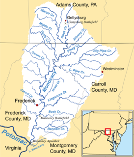
Double Pipe Creek, sometimes called Pipe Creek, is a major tributary of the Monocacy River in Carroll County and Frederick County in Maryland, located several miles north and west of Westminster. The creek is only 1.6 miles (2.6 km) long, but is formed by the confluence of two much longer streams, Big Pipe Creek and Little Pipe Creek.

Salmon Falls Creek is a tributary of the Snake River, flowing from northern Nevada into Idaho in the United States. Formed in high mountains at the northern edge of the Great Basin, Salmon Falls Creek flows northwards 121 miles (195 km), draining an arid and mountainous basin of 2,103 square miles (5,450 km2). The Salmon Falls Creek valley served as a trade route between the Native American groups of the Snake River Plain and Great Basin. Today, most of its water is used for irrigation.
The Feather Headwaters are 3 watersheds totaling 3,450 sq mi (8,900 km2) and which drain to Lake Oroville. The North Fork Feather Watershed is 1,090 sq mi (2,800 km2)—including the West Branch drainage of about 282.5 sq mi (732 km2). The East Branch North Fork Feather Watershed is 1,010 sq mi (2,600 km2), and the Middle Fork Feather Watershed is 1,350 sq mi (3,500 km2)—including the South Fork drainage of about 132 sq mi (340 km2). Headwaters drainage is impaired by the Palermo Canal at Oroville Dam, the Hendricks Canal at the West Branch Feather River, and the Miners Ranch Canal at the South Fork's Ponderosa Reservoir. Additionally, the Pacific Gas and Electric Company releases Upper Feather water into the Hyatt Generating-Pumping Plant for hydroelectric generation during daily peak demand.
The Little River is a tributary of the Neuse River, which originates in Moore's Pond, south of Youngsville in Franklin County. The river crosses through Wake, Johnston, and Wayne counties, joining the Neuse at Waynesborough State Park and Busco Beach just east of Goldsboro. Wake County and the City of Raleigh have been purchasing land in the watershed in order to create a reservoir in northeast Wake County.

Stoney Creek, or Stony Creek, is a watercourse in Wayne County, North Carolina, USA, that flows through the city of Goldsboro, North Carolina in its lower course before joining the Neuse River.
The H.F. Lee Energy Complex, formerly the Goldsboro Plant, is an electrical power generating complex operated by Duke Energy. The power complex was originally owned by the Carolina Power & Light Company, which inaugurated a coal-fired power plant in 1951. Two more coal plants were added in 1952 and 1962, and then oil-fueled turbines were added in 1967–71. In 2012 these units were shut down and replaced by four gas-fired units. The Quaker Neck Lake was built as a cooling pond for the coal-fired power stations, and is still used to supply cooling water. It was originally impounded by a low dam on the Neuse River, but in 1998 the dam was removed, while the lake remained contained in an earthen wall. This change allowed fish to migrate further upstream for spawning. Ash ponds near the lake hold toxic coal ash. There are plans to remove and recycle or bury the ash.
