This article needs additional citations for verification .(April 2021) |
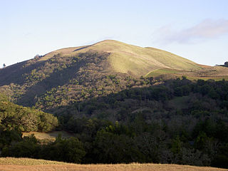
Bear Mountain is a mountain summit along the crest of the Diablo Range in Santa Clara County, California. Its summit lies at an elevation of 2,477 feet (755 meters). [1]
This article needs additional citations for verification .(April 2021) |
Bear Mountain is a mountain summit along the crest of the Diablo Range in Santa Clara County, California. Its summit lies at an elevation of 2,477 feet (755 meters). [1]
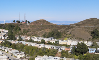
The Twin Peaks are two prominent hills with an elevation of about 925 feet (282 m) located near the geographic center of San Francisco, California. The Twin Peaks are the second and third highest natural points in San Francisco; only 928 foot (283 m) Mount Davidson is higher within city limits.

Uvas Canyon County Park is a 1,147-acre (464 ha) natural park located in upper Uvas Canyon on the eastern side of the Santa Cruz Mountains, west of Morgan Hill, California. The park has several small waterfalls, some of which flow perennially, that feed into tributaries confluent with Uvas Creek. The park is part of the Santa Clara County Parks System, and facilitates picnics, hiking and overnight camping. It is one of the few parks in the area that allows dogs in the campgrounds.
Rock Creek (California) may refer to the following streams:

The Dark Divide is the largest roadless area in western Washington state, comprising approximately 76,000 acres (310 km2) of intact wilderness on Juniper Ridge linking Mount St. Helens and Mount Adams in the southern Cascade Mountains of Washington. In two remote valleys of the Lewis River drainage are 500-year-old trees. These ancient forests are protected from logging as reserves for the northern spotted owl and other species under the Northwest Forest Plan.
Arctic Pacific Lakes Provincial Park is a provincial park in British Columbia, Canada, protecting a pair of lakes known as Arctic and Pacific Lakes, which as their name indicate are on the divide between the Pacific and Arctic drainages. Inherently, the Continental Divide runs between the two lakes, which lie in a narrow valley amid the rugged mountains of the northwesternmost McGregor Plateau. The pass formed by the lakes was important during early fur trade operations and was one of the main links between New Caledonia and the fur companies' eastern territories beyond the Rockies.
Limestone Run is a 4.6-mile-long (7.4 km) stream that lies to the east of New Creek Mountain in Mineral County, West Virginia. It is a tributary of the North Branch Potomac River.

Redwood Estates is a rural unincorporated community along State Route 17 in the coastal Santa Cruz Mountains in Los Gatos, California, United States. The Census Bureau includes it in a census-designated place named Lexington Hills. It lies inside the confines of Santa Clara County. The area is about eight miles from downtown Los Gatos and nine miles from the Santa Cruz County community of Scotts Valley.

Hickok is an unincorporated community in Grant County, Kansas, United States. It lies in eastern Lincoln Township along U.S. Route 160, 7 miles (11 km) east of the county seat of Ulysses.
Greenwood Mountain is the name of several mountain summits in the United States.
Bald Mountain is a name given to over fifty summits in California.
Summit is a small unincorporated community more frequently referred to by locals as the Loma Prieta Community located partially in Santa Clara County but predominantly in Santa Cruz County, California, in the mountain ranges of the Santa Cruz Mountains. It lies at the summit along Highway 17 from which is gets its name. Home to a series of abandoned railroad towns and tunnels from the South Pacific Coast Railroad which operated until the 1940s, Public transportation by bus is also no longer available from the Summit Road area. VTA route 76 has been cancelled since June 2010, and the Highway 17 Express only stops in Scotts Valley. It is one of the few places in the San Francisco Bay Area to receive snowfall and the mountain pass which links the Silicon Valley and Monterey Bay is closed at this spot when snowfall is too heavy. The next town to the south is Scotts Valley and to the north Redwood Estates. The area serves as a rest stop with food for people traveling across the mountains.
KPHI is a radio station located in Honolulu, Hawaii. The station is owned by H. Hawaii Media and airs a Hawaiian oldies format. The studios are located in Downtown Honolulu and the transmitter is located near Mililani. KPHI is rebroadcast on FM translator K244EO in Honolulu and on Spectrum digital channel 882 throughout the state of Hawaii.
Fernside is a neighborhood of Alameda in Alameda County, California. It lies at an elevation of 13 feet. Located near the Fruitvale and High Street bridges, it previously contained one train line which passed over the Fruitvale Bridge and another which followed the perimeter of Alameda's South Shore.

Bear Peak is a mountain summit in the Front Range of the Rocky Mountains of North America. The 8,459-foot (2,578 m) peak is located in Boulder Mountain Park, 5.2 miles (8.3 km) south-southwest of downtown Boulder in Boulder County, Colorado, United States.
Gwinn Mountain is a summit in West Virginia, in the United States. With an elevation of 2,949 feet (899 m), Gwinn Mountain is the 383rd highest summit in the state of West Virginia.
Vail Mountain is a summit in Iron County in the U.S. state of Missouri. The summit has an elevation of 1,404 feet (428 m). Vail Mountain lies to the east of Russell Mountain and the road to the summit of Taum Sauk Mountain passes just west of the summit of Vail Mountain. Routes 21 and 72 traverse the south spur of the mountain before heading south through Royal Gorge. The summit is about 3 miles (4.8 km) southwest of Arcadia and Ironton.
La Vereda del Monte was a backcountry route through remote regions of the Diablo Range, one of the California Coast Ranges. La Vereda del Monte was the upper part of La Vereda Caballo,, used by mesteñeros from the early 1840s to drive Alta California horses to Sonora for sale.
Mississippi Creek is a tributary stream to Pacheco Creek in Santa Clara County, California.
Mustang Peak is a mountain summit along the divide of the Diablo Range in Stanislaus County, California. It rises to an elevation of 2,251 / 686 meters.
Red Hill is a summit on the eastern slope of the Diablo Range, in Merced County, California. Its highest elevation is 2,326 feet. The summit is part of a long ridge where its high point is between 37°07′35″N121°11′31″W and 37°07′27″N121°11′50″W. The Red Mountain Road, runs over this ridge between Fifield Road on the divide of the Diablo Range and McCabe Road on Romero Creek.
37°13′44″N121°26′18″W / 37.22889°N 121.43833°W
| | This Santa Clara County, California-related article is a stub. You can help Wikipedia by expanding it. |