Clarendon Park is a settlement in Clarendon Parish in south-central Jamaica.

O Baixo Miño is a comarca in the Galician province of Pontevedra. The area covers 315.1 km2, and the overall population of this comarca was 50,978 at the 2011 Census; the latest official estimate was 49,646. To the west of O Baixo Miño lies the Atlantic Ocean and to its southeast is the Minho River, which forms a natural boundary with Portugal.
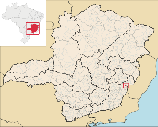
Reduto is a Brazilian municipality located in the state of Minas Gerais. The city belongs to the mesoregion of Zona da Mata and to the microregion of Manhuaçu. As of 2020, the estimated population was 7,201.
Kalitnik is a village in the administrative district of Gmina Michałowo, within Białystok County, Podlaskie Voivodeship, in north-eastern Poland, close to the border with Belarus.
Kuchmy-Kuce is a village in the administrative district of Gmina Michałowo, within Białystok County, Podlaskie Voivodeship, in north-eastern Poland, close to the border with Belarus.
Suche, is a village in the administrative district of Gmina Poronin, within Tatra County, Lesser Poland Voivodeship, in southern Poland. It lies approximately 2 kilometres (1 mi) south-west of Poronin, 5 km (3 mi) north-east of Zakopane, and 81 km (50 mi) south of the regional capital Kraków.
Huta Nowa is a village in the administrative district of Gmina Bieliny, within Kielce County, Świętokrzyskie Voivodeship, in south-central Poland. It lies approximately 6 kilometres (4 mi) east of Bieliny and 27 km (17 mi) east of the regional capital Kielce.
Rzepin Pierwszy is a village in the administrative district of Gmina Pawłów, within Starachowice County, Świętokrzyskie Voivodeship, in south-central Poland. It lies approximately 3 kilometres (2 mi) north-west of Pawłów, 8 km (5 mi) south of Starachowice, and 35 km (22 mi) east of the regional capital Kielce.
Rywaczki is a village in the administrative district of Gmina Miedźno, within Kłobuck County, Silesian Voivodeship, in southern Poland. It lies approximately 13 kilometres (8 mi) north-east of Kłobuck and 82 km (51 mi) north of the regional capital Katowice.
Świeszyno is a village in Gmina Miastko, Bytów County, Pomeranian Voivodeship, in northern Poland. It lies approximately 21 kilometres (13 mi) south-west of Bytów and 68 km (42 mi) south-west of Gdańsk.
Grabice is a village in the administrative district of Gmina Murów, within Opole County, Opole Voivodeship, in south-western Poland.
Kralltown is an unincorporated community in Washington Township, York County, Pennsylvania, United States.
Aleksandrovo is a village in Haskovo Municipality, in Haskovo Province, in southern Bulgaria.
Milentija is a village in the municipality of Brus, Serbia. According to the 2002 census, the village has a population of 184 people.
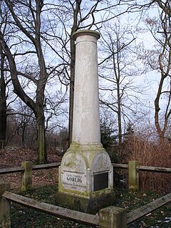
Gohlig is a mountain of Saxony, southeastern Germany.
Salu is a village in Põhja-Pärnumaa Parish, Pärnu County in southwestern Estonia.
Kalmu is a village in Saaremaa Parish, Saare County in western Estonia.

National Highway 3 (NR3) is one of the most important highways of central-eastern Burma. It connects Mandalay to Muse on the border with China.
Pribidoli is a village in the municipality of Srebrenica, Bosnia and Herzegovina.
Madna is a town and commune in Tiaret Province in northwestern Algeria.
This page is based on this
Wikipedia article Text is available under the
CC BY-SA 4.0 license; additional terms may apply.
Images, videos and audio are available under their respective licenses.
