Look up Beddington in Wiktionary, the free dictionary.
Beddington or Bedington can refer to:
Beddington or Bedington can refer to:
Richmond most often refers to:
Chelsea or Chelsey may refer to:

Beddington is a suburban settlement in the London Borough of Sutton on the boundary with the London Borough of Croydon. Beddington is formed from a village of the same name which until early the 20th century still included land which became termed entirely as Wallington. The latter was in the 13th century shown on local maps as Hakebrug, and named after a bridge on the River Wandle. The locality has a landscaped wooded park at Beddington Park – also known as Carew Manor; and a nature reserve and sewage treatment works in the centre and to the north of its area respectively. The population of Beddington according to the 2011 census is 21,044.

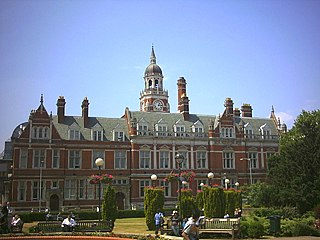
Wallington is a town in the London Borough of Sutton, South London, England, 9.7 miles (15.6 km) south-west of Charing Cross. Before the Municipal Borough of Beddington and Wallington merged into the London Borough of Sutton in Greater London in 1965, it was part of the county of Surrey. Wallington is a post town in the SM postcode area.

The London Borough of Sutton is an Outer London borough in south-west London, England. It covers an area of 43 km2 (17 sq mi) and is the 80th largest local authority in England by population. It borders the London Borough of Croydon to the east, the London Borough of Merton to the north and the Royal Borough of Kingston upon Thames to the north-west; it also borders the Surrey boroughs of Epsom and Ewell to the west and Reigate and Banstead to the south. The local authority is Sutton London Borough Council. Its principal town is the eponymous Sutton.
The County Borough of Croydon was a local government district in and around the town of Croydon in north east Surrey, England from 1889 to 1965. Since 1965 the district has been part of the London Borough of Croydon within Greater London.
Barking may refer to:

The town is the basic unit of local government and local division of state authority in the six New England states. Most other U.S. states lack a direct counterpart to the New England town. New England towns overlay the entire area of a state, similar to civil townships in other states where they exist, but they are fully functioning municipal corporations, possessing powers similar to cities and counties in other states. New Jersey's system of equally powerful townships, boroughs, towns, and cities is the system which is most similar to that of New England. New England towns are often governed by a town meeting legislative body. The great majority of municipal corporations in New England are based on the town model; there, statutory forms based on the concept of a compact populated place are uncommon, though elsewhere in the U.S. they are prevalent. County government in New England states is typically weak at best, and in some states nonexistent. Connecticut, for example, has no county governments, nor does Rhode Island. Both of those states retain counties only as geographic subdivisions with no governmental authority, while Massachusetts has abolished eight of fourteen county governments so far. Counties serve mostly as dividing lines for the states' judicial systems and some other state services in the southern New England states, while providing varying services in the more sparsely populated three northern New England states.

Sutton and Cheam was a local government district in northeast Surrey, England from 1882 to 1965.
Beddington and Wallington was, from 1915 to 1965, a local government district in north east Surrey, England. It formed part of the London suburbs, lying within the Metropolitan Police District and the London Passenger Transport Area. In 1965 it was abolished on the creation of Greater London.
Bedington is an unincorporated community on Hoke Run, near its confluence with Opequon Creek, in Berkeley County, West Virginia, United States. It is located east of Hainesville on County Route 5. According to the Geographic Names Information System, Bedington has also been known as Beddington, Bedenton, and The Lick.

Sandstone Valley is a suburban neighbourhood in northwest Calgary, Alberta, Canada. Located northwest of the community of Beddington Heights, this primarily low-density residential community is bounded by Country Hills Boulevard to the north, Beddington Trail to the east, Berkshire Boulevard to the south and 14th Street W to the west. The Nose Hill Park is located southwest from the community.
Beddington Heights is an established suburban neighbourhood in northwest Calgary, Alberta, Canada. The community is bounded by Berkshire Boulevard to the north, Beddington Trail to the east, Beddington Boulevard to the south and 14th Street W to the west.
Carshalton was a constituency combining with areas to the south-west, then to the east instead, Carshalton which is a suburb on a long, north–south hillside south of London. The latter form saw it take up an eastern "half" of the London Borough of Sutton. It returned one Member of Parliament (MP) to the House of Commons of the Parliament of the United Kingdom.
Hidden Valley is a residential neighbourhood in the northwest quadrant of Calgary, Alberta. It is located close to the northern edge of the city, and is bounded by Stoney Trail to the north, Beddington Trail to the east, Country Hills Boulevard to the south, and Shaganappi Trail to the west.
Sutton London Borough Council is the local authority for the London Borough of Sutton in Greater London, England. It is a London borough council, one of 32 in the United Kingdom capital of London. Sutton is divided into 18 wards, each electing three councillors. Following the May 2018 council election, Sutton London Borough Council comprises 33 Liberal Democrat councillors, 18 Conservative Party councillors, and 3 Independent councillors, a decrease of the Liberal Democrat majority. The council was created by the London Government Act 1963 and replaced three local authorities: Beddington and Wallington Borough Council, Sutton and Cheam Borough Council and Carshalton Urban District Council.
The 1964 Sutton Council election took place on 7 May 1964 to elect members of Sutton London Borough Council in London, England. The whole council was up for election and the Conservative party gained control of the council.

The 2018 Sutton Council election took place on 3 May 2018 to elect members of Sutton Council in London. This was on the same day as other local elections.
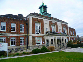
Wallington Town Hall is a municipal building in Woodcote Road, Wallington, London. It is a Grade II listed building.