
Somerset County is a county in the state of Maine, in the United States. As of the 2010 census, the population was 52,228. Its county seat is Skowhegan.

Piscataquis County is a county located in the U.S. state of Maine. As of the 2010 census, its population was 17,535, making it Maine's least-populous county. Its county seat is Dover-Foxcroft. The county was incorporated on 23 March 1838, taken from the western part of Penobscot County and the eastern part of Somerset County, and is named for an Abenaki word meaning "branch of the river" or "at the river branch."

Aroostook County is a county in the U.S. state of Maine along the Canada–U.S. border. As of the 2010 census, the population was 71,870. Its seat is Houlton.

Harrison is a town in Cumberland County, Maine, United States. The population was 2,730 at the 2010 census. A historic resort area, Harrison straddles Long Lake and Crystal Lake. It is part of the Portland–South Portland–Biddeford, Maine metropolitan statistical area.

Naples is a town in Cumberland County, Maine, United States. It is part of the Portland–South Portland–Biddeford, Maine metropolitan statistical area. The population was 3,872 at the 2010 census, and it is home to part of Sebago Lake State Park. Naples is a resort area.

New Gloucester is a town in Cumberland County, Maine, in the United States. It is home to the Sabbathday Lake Shaker Village, the last active Shaker village in the U.S. The town's population was 5,542 at the 2010 census.
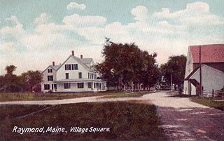
Raymond is a town in Cumberland County, Maine, United States. The population was 4,436 at the 2010 census. It is a summer recreation area and is part of the Portland–South Portland–Biddeford, Maine metropolitan statistical area. Raymond Neck is the landing for the ferry to the town of Frye Island in Sebago Lake. The Raymond school system is currently affiliated with the Windham school system in a district known as RSU 14.
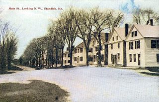
Standish is a town in Cumberland County, Maine, United States. The population was 10,139 at the 2015 census. It includes the villages of Standish Corner, Sebago Lake Village and Steep Falls, and the localities known as Richville, Standish Neck and Two Trails. Standish is part of the Portland-South Portland-Biddeford, Maine metropolitan statistical area.

Beddington is a town in Washington County, Maine, United States. The population was 50 at the 2010 census. It is the smallest organized town in Maine.
The Narraguagus River is a river located in the U.S. state of Maine with its mouth in the Narraguagus Bay of the Gulf of Maine. It flows through the town of Cherryfield and was formerly well known for its sport fly fishing for Atlantic salmon. This was a traditional highlight of late spring with anglers gathering from afar for the Memorial Day weekend fishing kick-off. The native salmon run has unfortunately been much reduced due to many different factors.

State Route 193 (SR 193) is part of Maine's system of numbered state highways. It runs 19.08 miles (30.71 km) from an intersection at U.S. Route 1 (US 1) in Cherryfield to rural East Hancock, Hancock County at State Route 9 near Beddington. SR 193 originally ran between East Eddington and East Holden. The original route was renumbered SR 175, and 193 was moved to its current location. The new route originally ran closer to Beddington Lake, but the road was not suitable for heavy traffic, and a new connector to its current terminus was built in 1956. The northern terminus is just south of Lead Mountain.
The Pleasant River is a river in Washington County, Maine. From the outflow of Pleasant River Lake in Beddington, the river runs 44.8 miles (72.1 km) south, east, and south to Pleasant Bay. The river's mouth is on the border between the towns of Harrington and Addison.

Lead Mountain, at 1,479-foot (451 m) high is a peak in eastern Maine. Lead Mountain is located north of the town of Beddington on the border of Hancock and Washington counties in Downeast Maine. The isolation of Lead Mountain is 35.73 miles, and it is easily visible from miles away along Maine state routes 9 and 193
Bear Pond is a lake in Hancock County, Maine, United States. It is located less than 0.5 miles (0.80 km) west of the Washington County border, approximately 1 mi (1.6 km) southeast of the summit of Lead Mountain, and 1.2 mi (1.9 km) northwest of Maine State Route 9 near the town of Beddington. The inflow to Bear Pond comes primarily from Bear Brook, which drains the southeastern slopes of Lead Mountain, which comprises primarily the Bear Brook Watershed in Maine (BBWM), an experimental forest. There are two USGS stream gauges on the East and West Branches of Bear Brook. An unpaved road provides access to the BBWM from state route 9 and passes about 200 feet (61 m) from the eastern end of the pond. Bear Pond is surrounded by forest and is drained at its western end by the Little Narraguagus River.

Upper Lead Mountain Pond is a lake in Hancock County, Maine, United States. It is located less than 1.5 miles (2.4 km) west of the Lead Mountain and 0.25 mi (0.40 km) north of Maine State Route 9 near the town of Beddington. The inflow to Bear Pond comes from several small stream, and it drains via a small 500 feet (150 m) stream to Middle/Lower Lead Mountain Pond. Several unpaved roads provide access to the lake and private residences surrounding it. The Lake is surrounded by forest and supports several fish, including landlocked Atlantic salmon, brook trout, white perch, yellow perch, and chain pickerel.

Pushaw Lake is a lake in Penobscot County, Maine, United States about 6.5 miles (10.5 km) north of downtown Bangor and 4.5 mi (7.2 km) west of downtown Orono. The lake is part of the towns of Orono, Old Town, Hudson, and Glenburn. There are roads and private residences along much of the lake, except the southeastern side where the Caribou Bog complex borders the lake. A small dam was constructed in 1920 at the lake's outflow to maintain constant water levels.
The Bear Brook Watershed in Maine (BBWM) is an experimental forest operated by the University of Maine in Hancock County, Maine, United States. The BBWM focuses around the two small first order branches of Bear Brook on the southeastern slopes of Lead Mountain above Bear Pond. Two years of monitoring studies began in 1987, after which the two watersheds of East and West Bear Brook were determined to be nearly identical. The West Bear Brook watershed was experimentally acidified with ammonium sulfate every other month from November 1989 until August 2016 to study the effects of sulfur and nitrogen acid deposition. East Bear Brook has been used as an untreated reference. Related research topics at BBWM include climate change, carbon sequestration, base cation depletion, and watershed biogeochemistry. There are two USGS stream gauges on the East and West Branches of Bear Brook.


