
The United States Virgin Islands, officially the Virgin Islands of the United States, are a group of Caribbean islands and an unincorporated and organized territory of the United States. The islands are geographically part of the Virgin Islands archipelago and are located in the Leeward Islands of the Lesser Antilles.

The Virgin Islands are an archipelago in the Caribbean Sea. They are geologically and biogeographically the easternmost part of the Greater Antilles, the northern islands belonging to the Puerto Rico Trench and St. Croix being a displaced part of the same geologic structure. Politically, the British Virgin Islands have been governed as the western island group of the Leeward Islands, which are the northern part of the Lesser Antilles, and form the border between the Caribbean Sea and the Atlantic Ocean. The archipelago is separated from the true Lesser Antilles by the Anegada Passage and from the main island of Puerto Rico by the Virgin Passage.

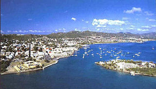
Charlotte Amalie, located on St. Thomas, is the capital and the largest city of the United States Virgin Islands. It was founded in 1666 as Taphus. In 1691, the town was renamed to Charlotte Amalie after the Danish queen Charlotte Amalie of Hesse-Kassel (1650–1714). It has a deep-water harbor that was once a haven for pirates and is now one of the busiest ports of call for cruise ships in the Caribbean, with about 1.5 million-plus cruise ship passengers landing there annually. Protected by Hassel Island, the harbor has docking and fueling facilities, machine shops, and shipyards and was a U.S. submarine base until 1966. The Town has been inhabited for centuries. When Christopher Columbus arrived in 1493, the area was inhabited by Caribs, Arawaks, Ciboney and Taíno native peoples. It is on the southern shore at the head of Saint Thomas Harbor. In 2010 the City had a population of 18,481, which makes it the largest city in the Virgin Islands Archipelago. Hundreds of ferries and yachts pass by the Town each week.
Saint Croix is an island in the Caribbean Sea, and a county and constituent district of the United States Virgin Islands (USVI), an unincorporated territory of the United States.
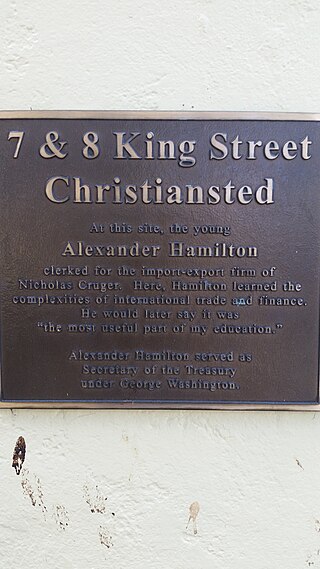
Christiansted is the largest town on Saint Croix, one of the main islands composing the United States Virgin Islands, a territory of the United States of America. The town is named after King Christian VI of Denmark.
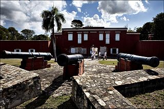
Frederiksted is both the town and one of the two administrative districts of St. Croix, U.S. Virgin Islands. It is a grid-planned city, designed by surveyor Jens Beckfor, originally to 14x14 blocks but built 7x7 to enhance the island commerce in the 1700s. Frederiksted has fewer than 1,000 people in the town proper, but nearly 10,000 in the greater western side of the island. Christiansted is about 30 years older but commerce was limited by its natural, shallow protective reef. Frederiksted was built in the leeward side of the island for calm seas and a naturally deep port. It is home to Fort Frederik, constructed to protect the town from pirate raids and attacks from rival imperialist nations and named after Frederick V of Denmark, who purchased the Danish West Indies in 1754.
Virgin Islands Creole, or Virgin Islands Creole English, is an English-based creole consisting of several varieties spoken in the Virgin Islands and the nearby SSS islands of Saba, Saint Martin and Sint Eustatius, where it is known as Saban English, Saint Martin English, and Statian English, respectively.

The United States Virgin Islands, often abbreviated USVI, are a group of islands and cays located in the Lesser Antilles of the Eastern Caribbean, consisting of three main islands and fifty smaller islets and cays. Like many of their Caribbean neighbors, the history of the islands is characterized by native Amerindian settlement, European colonization, and the Atlantic slave trade.

Bethlehem Old Work is a settlement on the island of Saint Croix in the United States Virgin Islands. It was set-up as one of the first plantations in the 1730s, and operated as the last sugar plantation on the island until the Bethlehem Central Factory closed in 1966.
Bettys Hope is a settlement on the island of Saint Croix in the United States Virgin Islands.

Sugar production in the United States Virgin Islands was an important part of the economy of the United States Virgin Islands for over two hundred years. Long before the islands became part of the United States in 1917, the islands, in particular the island of Saint Croix, was exploited by the Danish from the early 18th century and by 1800 over 30,000 acres were under cultivation, earning Saint Croix a reputation as the "Garden of the West Indies". Since the closing of the last sugar factory on Saint Croix in 1966, the industry has become only a memory.
Green Kay is a settlement on the island of Saint Croix in the United States Virgin Islands. It is located 3.3 miles (5.3 km) east of Christiansted.
Hogensborg is a settlement on the island of Saint Croix in the United States Virgin Islands.
Libanon Hill is a settlement on the island of Saint Croix in the United States Virgin Islands.
Sion Hill is a settlement on the island of Saint Croix, in the United States Virgin Islands.
Sprat Hall Beach is a settlement on the island of Saint Croix in the United States Virgin Islands.
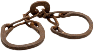
The Danish slave trade occurred separately in two different periods: the trade in European slaves during the Viking Age, from the 8th to 10th century; and the Danish role in selling African slaves during the Atlantic slave trade, which commenced in 1733 and ended in 1807 when the abolition of slaves was announced. The location of the latter slave trade primarily occurred in the Danish West Indies where slaves were tasked with many different manual labour activities, primarily working on sugar plantations. The slave trade had many impacts that varied in their nature, with some more severe than others. After many years of slavery in the Danish West Indies, Christian VII decided to abolish slave trading.

U.S. Virgin Islands Governor's Mansion may refer to any one of the three official residences owned by the government of the U.S. Virgin Islands and provided to the Governor of the United States Virgin Islands. One residence is located on each of the three largest inhabited islands of this U.S. territory in the Caribbean. The U.S. Virgin Islands maintains more official gubernatorial residences than any other state or territory of the United States.
The Indian community in the United States Virgin Islands is made up of Indo-Caribbeans, Indian Americans and other persons of Indian origin. The first Indians in the United States Virgin Islands (USVI) arrived in the Danish colony of Saint Croix in June 1863 as indentured workers. However, the nearly all 325 Indians who came to Saint Croix left the island by the 1870s. Nearly two-thirds returned to India, while the others emigrated to Trinidad and Tobago. Some settled in that country, while others returned to India from Trinidad.
Beeston Hill may refer to the following places:
