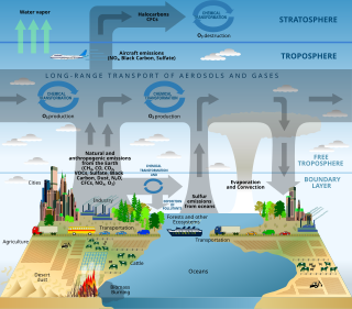
Surface-water hydrology is the sub-field of hydrology concerned with above-earth water, in contrast to groundwater hydrology that deals with water below the surface of the Earth. Its applications include rainfall and runoff, the routes that surface water takes, and the occurrence of floods and droughts. Surface-water hydrology is used to predict the effects of water constructions such as dams and canals. It considers the layout of the watershed, geology, soils, vegetation, nutrients, energy and wildlife. Modelled aspects include precipitation, the interception of rain water by vegetation or artificial structures, evaporation, the runoff function and the soil-surface system itself.
Equifinality is the principle that in open systems a given end state can be reached by many potential means. Also meaning that a goal can be reached by many ways. The term and concept is due to Hans Driesch, the developmental biologist, later applied by Ludwig von Bertalanffy, the founder of general systems theory, and by William T. Powers, the founder of perceptual control theory. Driesch and von Bertalanffy prefer this term, in contrast to "goal", in describing complex systems' similar or convergent behavior. Powers simply emphasised the flexibility of response, since it emphasizes that the same end state may be achieved via many different paths or trajectories. In closed systems, a direct cause-and-effect relationship exists between the initial condition and the final state of the system: When a computer's 'on' switch is pushed, the system powers up. Open systems, however, operate quite differently. The idea of equifinality suggests that similar results may be achieved with different initial conditions and in many different ways. This phenomenon has also been referred to as isotelesis when in games involving superrationality.

In hydrology, a water balance equation can be used to describe the flow of water in and out of a system. A system can be one of several hydrological domains, such as a column of soil or a drainage basin. Water balance can also refer to the ways in which an organism maintains water in dry or hot conditions. It is often discussed in reference to plants or arthropods, which have a variety of water retention mechanisms, including a lipid waxy coating that has limited permeability.

An hydrological transport model is a mathematical model used to simulate river or stream flow and calculate water quality parameters. These models generally came into use in the 1960s and 1970s when demand for numerical forecasting of water quality was driven by environmental legislation, and at a similar time widespread access to significant computer power became available. Much of the original model development took place in the United States and United Kingdom, but today these models are refined and used worldwide.
The HBV hydrology model, or Hydrologiska Byråns Vattenbalansavdelning model, is a computer simulation used to analyze river discharge and water pollution. Developed originally for use in Scandinavia, this hydrological transport model has also been applied in a large number of catchments on most continents.
In hydrology and sewage collection and disposal, antecedent moisture is the relative wetness or dryness of a watershed or sanitary sewershed. Antecedent moisture conditions change continuously and can have a very significant effect on the flow responses in these systems during wet weather. The effect is evident in most hydrologic systems including stormwater runoff and sanitary sewers with inflow and infiltration. Many modeling and analysis challenges that are created by antecedent moisture conditions are evident within combined sewers and separate sanitary sewer systems.
Intermittent rivers cease to flow every year or at least twice every five years. Such rivers drain large arid and semi-arid areas, covering approximately a third of the earth’s surface. The extent of temporary rivers is increasing, as many formerly perennial rivers are becoming temporary because of increasing water demand, particularly for irrigation. The combination of dry crusted soils and the highly erosive energy of the rain cause sediment resuspension and transport to the coastal areas. They are among the aquatic habitats most altered by human activities. During the summer even under no flow conditions the point sources are still active such as the wastewater effluents, resulting in nutrients and organic pollutants accumulating in the sediment. Sediment operates as a pollution inventory and pollutants are moved to the next basin with the first flush. Their vulnerability is intensified by the conflict between water use demand and aquatic ecosystem conservation. Advanced modelling tools have been developed to better describe intermittent flow dynamic changes such as the tempQsim model.
Generalized likelihood uncertainty estimation (GLUE) is a statistical method used in hydrology for quantifying the uncertainty of model predictions. The method was introduced by Keith Beven and Andrew Binley in 1992. The basic idea of GLUE is that given our inability to represent exactly in a mathematical model how nature works, there will always be several different models that mimic equally well an observed natural process. Such equally acceptable or behavioral models are therefore called equifinal.
Geographic information systems (GISs) have become a useful and important tool in the field of hydrology to study and manage Earth's water resources. Climate change and greater demands on water resources require a more knowledgeable disposition of arguably one of our most vital resources. Because water in its occurrence varies spatially and temporally throughout the hydrologic cycle, its study using GIS is especially practical. Whereas previous GIS systems were mostly static in their geospatial representation of hydrologic features, GIS platforms are becoming increasingly dynamic, narrowing the gap between historical data and current hydrologic reality.

A hydrologic model is a simplification of a real-world system that aids in understanding, predicting, and managing water resources. Both the flow and quality of water are commonly studied using hydrologic models.
The Hydrologic Modeling System (HEC-HMS) is designed to simulate the precipitation-runoff processes of dendritic drainage basins. It is designed to be applicable in a wide range of geographic areas for solving the widest possible range of problems. This includes large river basin water supply and flood hydrology, and small urban or natural watershed runoff. Hydrographs produced by the program are used directly or in conjunction with other software for studies of water availability, urban drainage, flow forecasting, future urbanization impact, reservoir spillway design, flood damage reduction, floodplain regulation, and systems operation.
The following outline is provided as an overview of and topical guide to hydrology:
SWAT-CUP is a program designed to integrate various calibration/uncertainty analysis programs for SWAT using the same interface. Currently the program can run SUFI2, GLUE, and ParaSol. To create a project, the program guides the user through the input files necessary for running a calibration program. Each SWAT-CUP project contains one calibration method and allows user to run the procedure many times until convergence is reached. User can save calibration iterations in the iteration history for later use. Also we have made it possible to create charts of observed and simulated data and the predicted uncertainty about them.
DPHM-RS is a semi-distributed hydrologic model developed at University of Alberta, Canada.
Low-impact development (LID) is a term used in Canada and the United States to describe a land planning and engineering design approach to manage stormwater runoff as part of green infrastructure. LID emphasizes conservation and use of on-site natural features to protect water quality. This approach implements engineered small-scale hydrologic controls to replicate the pre-development hydrologic regime of watersheds through infiltrating, filtering, storing, evaporating, and detaining runoff close to its source. Green infrastructure investments are one approach that often yields multiple benefits and builds city resilience.
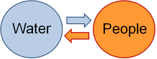
Socio-hydrology is an interdisciplinary field studying the dynamic interactions and feedbacks between water and people. Areas of research in socio-hydrology include the historical study of the interplay between hydrological and social processes, comparative analysis of the co-evolution and self-organization of human and water systems in different cultures, and process-based modelling of coupled human-water systems.
The flash flood guidance system (FFGS) was designed and developed by the Hydrologic Research Center a non-profit public-benefit corporation located in of San Diego, CA, US, for use by meteorological and hydrologic forecasters throughout the world. The primary purpose of the FFGS is to provide operational forecasters and disaster management agencies with real-time informational guidance products pertaining to the threat of small-scale flash flooding throughout a specified region. The FFGS provides the necessary products to support the development of warnings for flash floods from rainfall events through the use of remote-sensed precipitation and hydrologic models. The FFGS outputs are made available to users to support their analysis of weather-related events that can initiate flash floods and then to make a rapid evaluation of the potential for a flash flood at a location. To assess the threat of a local flash flood, the FFGS is designed to allow product adjustments based on the forecaster's experience with local conditions, incorporation of other information and any last minute local observations or local observer reports. The system supports evaluations of the threat of flash flooding over hourly to six-hourly time scales for stream basins that range in size from 25 to 200 km2 in size. Important technical elements of the flash flood guidance system are the development and use of a bias-corrected radar and/or satellite precipitation estimate field and the use of land-surface hydrologic modeling. The system then provides information on rainfall and hydrologic response, the two important factors in determining the potential for a flash flood. The system is based on the concept of flash flood guidance and flash flood threat. Both indices provide the user with the information needed to evaluate the potential for a flash flood, including assessing the uncertainty associated with the data.

Professor Murugesu Sivapalan is a Sri Lankan Tamil engineer, hydrologist and academic.