Beiar Valley

Last updated
Beiar Valley
Beiardalen
Beiarn IMG 4821 beiarn.JPG
Aerial photo of with an east-west view of the Beiar Valley, with Beiar Fjord at the top
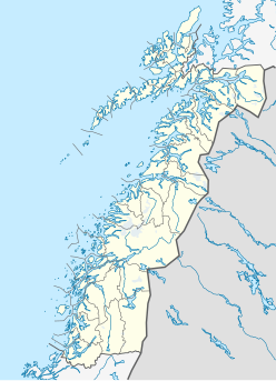
Norway Nordland location map.svg
Red pog.svg
Beiar Valley
Location of the valley
Norway location map.svg
Red pog.svg
Beiar Valley
Beiar Valley (Norway)
Length60 kilometres (37 mi)
Geology
TypeRiver valley
Geography
Location Nordland, Norway
Population centers Moldjord
Coordinates 66°43′53″N14°31′23″E / 66.7313°N 14.5230°E / 66.7313; 14.5230 Coordinates: 66°43′53″N14°31′23″E / 66.7313°N 14.5230°E / 66.7313; 14.5230
Rivers Beiar River

The Beiar Valley [1] (Norwegian : Beiardalen) is a valley in the municipality of Beiarn in Nordland, Norway. It is about 60 kilometers (37 mi) long. [2] Most of the residents of the municipality of Beiarn live in this valley.

Norwegian language North Germanic language spoken in Norway

Norwegian is a North Germanic language spoken mainly in Norway, where it is the official language. Along with Swedish and Danish, Norwegian forms a dialect continuum of more or less mutually intelligible local and regional varieties, and some Norwegian and Swedish dialects, in particular, are very close. These Scandinavian languages, together with Faroese and Icelandic as well as some extinct languages, constitute the North Germanic languages. Faroese and Icelandic are hardly mutually intelligible with Norwegian in their spoken form because continental Scandinavian has diverged from them. While the two Germanic languages with the greatest numbers of speakers, English and German, have close similarities with Norwegian, neither is mutually intelligible with it. Norwegian is a descendant of Old Norse, the common language of the Germanic peoples living in Scandinavia during the Viking Era.

Beiarn Municipality in Nordland, Norway

Beiarn is a municipality in Nordland county, Norway. It is part of the traditional district of Salten. Beiarn is also a part of the Bodø Region, a statistical metropolitan region. The administrative centre of the municipality is the village of Moldjord. Other villages in Beiarn are Høyforsmoen, Trones, and Tverrvika.

Nordland County (fylke) of Norway

Nordland is a county in Norway in the Northern Norway region, bordering Troms in the north, Trøndelag in the south, Norrbotten County in Sweden to the east, Västerbotten County to the southeast, and the Atlantic Ocean to the west. The county was formerly known as Nordlandene amt. The county administration is in Bodø. The remote Arctic island of Jan Mayen has been administered from Nordland since 1995.

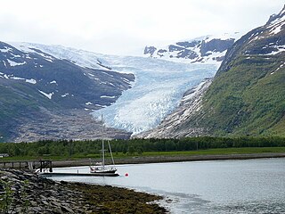
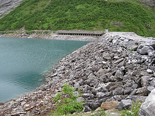
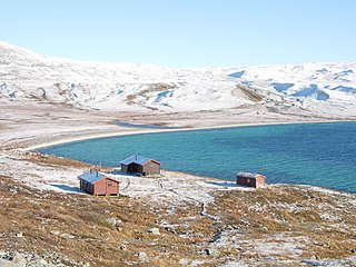
The highest parts of the southern end of the valley are located within Saltfjellet–Svartisen National Park. The Beiar River flows through the valley before emptying into the Beiar Fjord at the north end of the valley. [3] [4]

Saltfjellet–Svartisen National Park national park in Nordland, Norway

Saltfjellet–Svartisen National Park is a national park in Nordland county in Norway. It is located within the municipalities of Beiarn, Meløy, Rana, Rødøy, Saltdal, and Bodø. European route E06 and the Nordland Line both follow the southern and eastern borders around the park. The park's eastern border is the Norway-Sweden border and a portion of this border is shared with the Vindelfjällen Nature Reserve which lies in Sweden.

Beiar River river in Beiarn, Norway

The Beiar River is a river in the municipality of Beiarn in Nordland, Norway. The river begins at the Svartisen glacier high in the mountains near the municipal borders of Beiarn, Meløy, and Rana inside the Saltfjellet-Svartisen National Park. The river then flows north and then west through the Beiar Valley to the head of Beiar Fjord. It has a length of about 54 kilometers (34 mi) and a drainage area of 1,052 square kilometers (406 sq mi), and is among the largest rivers in Nordland county.

Beiar Fjord fjord in Beiarn and Gildeskål, Norway

Beiar Fjord is a fjord in Nordland, Norway. The fjord lies mostly within the municipality of Beiarn, but the westernmost part of the fjord lies in Gildeskål municipality. It has a length of about 20 kilometers (12 mi). The Norwegian County Road 17 crosses the fjord near the mouth via the Kjellingstraumen Bridge. The fjord ranges from 80 metres (260 ft) to 2 kilometres (1.2 mi) wide throughout its course.

Related Research Articles

Suldal Municipality in Rogaland, Norway

Suldal is a municipality in the northeast corner of Rogaland county, Norway. It is located in the traditional district of Ryfylke. Since 1965, the administrative centre of Suldal is the village of Sand i Ryfylke. Other villages in Suldal include Hålandsosen, Jelsa, Marvik, Nesflaten, and Suldalsosen.

Trøndelag Region and county of Norway

Trøndelag is a county in the central part of Norway. It was created in 1687, then named Trondhjem County ; in 1804 the county was split into Nord-Trøndelag and Sør-Trøndelag, and the counties were reunited in 2018. Trøndelag county and the neighboring Møre og Romsdal county together form what is known as Central Norway.

Svartisen glaciers in Nordland, Norway

Svartisen is a collective term for two glaciers located in Nordland county in northern Norway. It is part of Saltfjellet-Svartisen National Park, located in the Saltfjell mountain range. The glaciers are located in the municipalities of Beiarn, Meløy, Rana, and Rødøy. Svartisen consists of two separate glaciers that are separated by the 1-kilometre (0.62 mi) long Vesterdalen valley. The two glaciers are:

Arstaddalsdammen lake in Beiarn, Norway

Arstaddalsdammen is a lake that lies in the municipality of Beiarn in Nordland county, Norway. It is located about 15 kilometres (9.3 mi) southwest of the village of Moldjord. The 2.54-square-kilometre (0.98 sq mi) lake lies in the southern end of the Arstaddal valley, and it has a dam on the northern end. The dam was built in the 1960s. The water from the lake is piped to the nearby lake Sokumvatnet in Gildeskål Municipality. The lake serves as a reservoir for the Sundsfjord Hydroelectric Power Station.

Litle Sokumvatnet lake in Nordland, Norway

Litle Sokumvatnet is a lake that lies in Gildeskål Municipality in Nordland county, Norway. Litle Sokumvatnet lies directly northeast of the larger lake Sokumvatnet. The lake serves as a reservoir for the Forså Hydroelectric Power Station.

Nordre Bjøllåvatnet lake in Saltdal, Norway

Nordre Bjøllåvatnet (Norwegian) or Bajep Ruovdajávrre (Lule Sami) is a lake that lies in the municipality of Saltdal in Nordland county, Norway. The 9.93-square-kilometre (3.83 sq mi) lake is located inside Saltfjellet–Svartisen National Park, about 1 kilometre (0.62 mi) east of the border with the municipality of Beiarn and north of the border with the municipality of Rana. The lake flows out through the river Bjøllåga and ultimately into the river Ranelva.

Ramsgjelvatnet lake in Beiarn, Norway

Ramsgjelvatnet is a lake that lies in the municipality of Beiarn in Nordland county, Norway. The lake is located about 5 kilometres (3.1 mi) northeast of the village of Høyforsmoen and about 15 kilometres (9.3 mi) southeast of the village of Moldjord.

Moldjord Village in Northern Norway, Norway

Moldjord or Moldjorda is the administrative centre of the municipality of Beiarn in Nordland county, Norway. The village is located along the Beiar River, about 5 kilometres (3.1 mi) south of the river's mouth at the Beiar Fjord. The village is home to the Beiarn Church, the main church for the municipality. The village has about 150 residents.

Beiarn Church Church in Nordland, Norway

Beiarn Church is a parish church of the Church of Norway in Beiarn Municipality in Nordland county, Norway. It is located in the village of Moldjord. It is the main church for the Beiarn parish which is part of the Salten prosti (deanery) in the Diocese of Sør-Hålogaland. The white, wooden church was built in a long church style in 1873 by the architect L.W. Nissen. The church seats about 310 people.

Høyforsmoen Chapel Church in Nordland, Norway

Høyforsmoen Chapel is a parish church of the Church of Norway in Beiarn Municipality in Nordland county, Norway. It is located in the village of Høyforsmoen. It is an annex church for the Beiarn parish which is part of the Salten prosti (deanery) in the Diocese of Sør-Hålogaland. The white, wooden church was built in a long church style in 1960 by the architect Andreas W. Nygaard. The church seats about 200 people.

Høyforsmoen Village in Northern Norway, Norway

Høyforsmoen is a small village in the municipality of Beiarn in Nordland county, Norway. The village is located along the Beiar River in the Beiar Valley, about 20 kilometres (12 mi) southeast of the municipal centre of Moldjord. Høyforsmoen Chapel is located in this village. The lake Ramsgjelvatnet lies northeast of the village.

Salten District Court district court in Salten, Norway

Salten District Court is a district court located in the town of Bodø in Nordland county, Norway. The court serves the Salten district in the central part of the county as well as two outlying island municipalities. It includes the municipalities of Beiarn, Bodø, Fauske, Gildeskål, Meløy, Saltdal, Steigen, Sørfold, Værøy, and Røst. It also holds jurisdiction over the outlying territory of Jan Mayen. The court is subordinate to the Hålogaland Court of Appeal. The court is led by the chief judge Ingrid Johanne Lillevik. This court employs a chief judge, four other judges, and four prosecutors.

Láhko National Park national park in Nordland, Norway

Láhko National Park is a national park in the municipalities of Gildeskål, Meløy, and Beiarn in Nordland county, Norway. The park contains unique geological features, including Norway's largest area of karst and caves. Rare plants and charales are also found inside the park. The park was established in December 2012 and covers an area of 188 km2 (73 sq mi).

Forså Hydroelectric Power Station

The Forså Hydroelectric Power Station is a hydroelectric power station in the municipality of Gildeskål in Nordland county, Norway. Part of the plant's catchment area also lies in the municipality of Beiarn.

Sundsfjord Hydroelectric Power Station

The Sundsfjord Hydroelectric Power Station is a hydroelectric power station in the municipality of Gildeskål in Nordland county, Norway. Part of the plant's catchment area also lies in the municipality of Beiarn.

References

  1. Hallström, Gustaf. 1938. Monumental Art of Northern Europe from the Stone Age. I. The Norwegian Localities. Stockholm: Thule, p. 133.
  2. Venseth, Tove Bragstad. 2016. Vår vakre region. Bodø i Vinden (March 31).
  3. Lauritzen, Per Roger, ed. (2009). "Beiardalen". Norsk Fjelleksikon (in Norwegian). Arendal: Friluftsforlaget. ISBN   978-82-91-49547-7.
  4. Godal, Anne Marit (ed.). "Beiardalen". Store norske leksikon (in Norwegian). Oslo: Norsk nettleksikon. Retrieved 26 October 2013.