Beinn na h-Uamha

Last updated
Beinn na h-Uamha
Loch nan Gabhar - geograph.org.uk - 5990.jpg
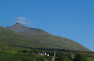
Beinn na h-Uamha (centre)
Highest point
Elevation 762 m (2,500 ft) [1]
Prominence 269 m (883 ft)
Listing Corbett, Marilyn
Geography
Location Lochaber, Scotland
Parent range Northwest Highlands
OS grid NM917664
Topo map OS Landranger 40

Beinn na h-Uamha (762 m) is a mountain in the Northwest Highlands of Scotland. It lies in the Ardgour area of Lochaber, west of the village of Corran.

The Northwest Highlands are located in the northern third of Scotland that is separated from the Grampian Mountains by the Great Glen. The region comprises Wester Ross, Assynt, Sutherland and part of Caithness. The Caledonian Canal, which extends from Loch Linnhe in the south-west, via Loch Ness to the Moray Firth in the north-east splits this area from the rest of the country. The city of Inverness and the town of Fort William serve as gateways to the region from the south.

Ardgour human settlement in United Kingdom

Ardgour is an area of the Scottish Highlands on the western shore of Loch Linnhe. It lies north of the district of Morvern and east of the district of Sunart. Administratively it is now part of the ward management area of Lochaber, in Highland council area. It forms part of the traditional shire and current registration county of Argyll.

Lochaber ward management area of the Highland Council

Lochaber is a name applied to areas of the Scottish Highlands. Historically, it consisted of the parishes of Kilmallie and Kilmonivaig, as they were before being reduced in extent by the creation of Quoad Sacra parishes in the 19th century; this Lochaber extended from the Northern shore of Loch Leven, a district called Nether Lochaber, to beyond Spean Bridge and Roy Bridge, which area is known as Brae Lochaber or Braigh Loch Abar in Gaelic. The town of Fort William is the main town and Lochaber was a distinct Province of Scotland in its own right. Lochaber is now also used to refer to a much wider area, one of the 16 ward management areas of the Highland Council of Scotland and one of eight former local government districts of the two-tier Highland region.

A steep and rugged peak, it provides fantastic views of Loch Linnhe and Sgùrr Dhòmhnuill from its summit. [2]

Loch Linnhe sea loch on the west coast of Scotland

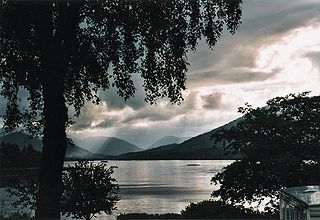
Loch Linnhe is a sea loch on the west coast of Scotland. The part upstream of Corran is known in Gaelic as An Linne Dhubh, and downstream as An Linne Sheileach. The name Linnhe is derived from the Gaelic word linne, meaning "pool".

Sgùrr Dhòmhnuill mountain in United Kingdom

Sgurr Dhòmhnuill or Sgurr Dhòmhnaill is a mountain in western Scotland. The summit lies about 10 km (6.2 mi) north-east of Strontian. Although less than Munro-height, it is one of Britain's biggest mountains in terms of height above sea level (AMSL), since it is the highest peak on the Ardgour peninsula.

Related Research Articles

Ben More (Mull) 966m high mountain in Scotland

Ben More is the highest mountain and only Munro on the Isle of Mull, Scotland.

Beinn Ìme 1011m high mountain in Scotland

Beinn Ìme is the highest mountain in the Arrochar Alps, in the Southern Highlands of Scotland. There are three usual routes of ascent. From Succoth, one may follow the same path that is used to reach The Cobbler before taking the right fork near the base of the Cobbler's main crags and continuing up the glen, across the bealach and up Ben Ìme's eastern ridge. Alternatively, the summit can be reached from the pass of Rest and be Thankful and from the Loch Lomond side, using the private road that leads to Loch Sloy. Beinn Ìme separates the Dunbartonshire landscape of Loch Lomond in the East and the Argyll Highlands of Loch Fyne and Loch Goil anywhere north, west, south west. Beinn Ìme is the landmark to the entrance to Argyll.

Beinn Dearg (Ullapool) 1084m high mountain in Scotland

Beinn Dearg is a mountain in the Inverlael area of the Highlands of Scotland. It is most frequently climbed by following the River Lael up Gleann na Sguaib. Starting from near the head of Loch Broom, a path follows the glen to a bealach, which is about a kilometre north of the summit. From this bealach, the neighbouring peaks of Con a' Mheall and Meall na Ceapraichean may also be climbed. Eididh nan Clach Geala, which lies about 3 km north of Beinn Dearg, is also added in to complete a round of 4 Munros.

Beinn a Chreachain 1080m high mountain in Scotland

Beinn a' Chreachain is a Scottish mountain, with a conical top, to the north-west of Loch Lyon.

Beinn a Chaorainn (Glen Spean) 1052m high mountain in Scotland

Beinn a’ Chaorainn is a Scottish mountain situated on the northern side of Glen Spean in the Lochaber region of the Highland Council area. The mountain which is located 30 km east-northeast of Fort William is one of several of the same name in the Scottish Highlands and should not be confused with another well known Beinn a’ Chaorainn in the Cairngorms.

Beinn a Chlachair Mountain in Scotland

Beinn a' Chlachair is a mountain in the Grampian Mountains of Scotland. It lies north of Loch Laggan, near the remote hamlet of Kinloch Laggan.

Beinn na Lap

Beinn na Lap is a mountain in the Grampian Mountains of Scotland. It lies at the northern end of Rannoch Moor, near to Corrour railway station.

Beinn Dearg (Blair Atholl)

Beinn Dearg is a mountain in the Grampian Mountains of Scotland. It lies north of the village of Blair Atholl in Perthshire.

Beinn a Chlaidheimh

Beinn a' Chlaidheimh is a remote mountain in the Northwest Highlands, Scotland. It lies in the wild Dundonnell and Fisherfield Forest in Wester Ross.

Beinn Eunaich Mountain in Scotland

Beinn Eunaich is a mountain in the Grampian Mountains of Scotland, located north of the village of Dalmally in Argyll and Bute.

Càrn na Caim

Carn na Caim is a mountain in the Grampian Mountains of Scotland. It lies on the border of Highland and Perth and Kinross, east of the Pass of Drumochter.

Beinn na Gucaig

Beinn na Gucaig is a mountain in the Grampian Mountains of Scotland, located south of Fort William in Lochaber.

Beinn a Chochuill

Beinn a' Chochuill is a mountain in the Grampian Mountains of Scotland, located east of Loch Etive in Argyll and Bute.

Beinn Bheoil

Beinn Bheoil is a mountain in the Grampian Mountains of Scotland, located on the western shore of Loch Ericht in Highland.

Beinn a Bhuiridh

Beinn a' Bhuidhe is a mountain in the Grampian Mountains of Scotland, west of the village of Dalmally in Argyll and Bute.

Beinn Each

Beinn Each is a mountain in the southern Grampian Mountains of Scotland. It is located in Stirlingshire, north of the town of Callander.

Beinn a Chearcaill

Beinn a' Chearcaill is a mountain in the Torridon Hills of northwest Scotland. It lies south of Loch Maree in Wester Ross.

Beinn na h-Eaglaise (Graham)

Beinn na h-Eaglaise is a mountain in the Northwest Highlands of Scotland. It lies in Wester Ross, south of the village of Torridon.

Beinn nan Eun

Beinn nan Eun is a mountain in the Northwest Highlands of Scotland. It is located in Easter Ross, several miles northwest of Dingwall.

Beinn nan Caorach

Beinn nan Caorach is a mountain in the Northwest Highlands of Scotland, It is located near the village of Corran in Lochalsh.

References

  1. "Beinn na h-Uamha". hill-bagging.co.uk. Retrieved 4 June 2019.
  2. "walkhighlands Beinn na h-Uamha". walkhighlands.co.uk. Retrieved 4 June 2019.