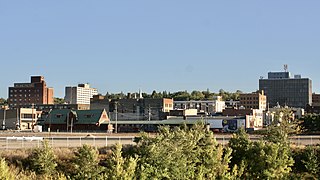
Minot is a city in and the county seat of Ward County, North Dakota, United States, in the state's north-central region. It is most widely known for the Air Force base approximately 15 miles (24 km) north of the city. With a population of 48,377 at the 2020 census, Minot is the state's fourth-most populous city and a trading center for a large part of northern North Dakota, southwestern Manitoba, and southeastern Saskatchewan. Founded in 1886 during the construction of James J. Hill's Great Northern Railway, Minot is also known as "Magic City", commemorating its remarkable growth in size over a short time.

Sunset Park is a neighborhood in the western part of the New York City borough of Brooklyn, bounded by Park Slope and Green-Wood Cemetery to the north, Borough Park to the east, Bay Ridge to the south, and New York Harbor to the west. The neighborhood is named for a public park of the same name that covers 24.5 acres (9.9 ha) between Fifth and Seventh Avenues from 41st to 44th Street. The area north of 36th Street is alternatively known as Greenwood Heights, while the section north of 20th Street is also called South Slope.
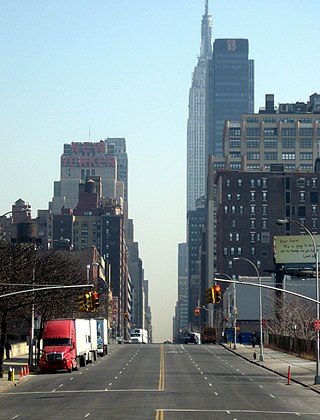
34th Street is a major crosstown street in the New York City borough of Manhattan. It runs the width of Manhattan Island from the West Side Highway on the West Side to FDR Drive on the East Side. 34th Street is used as a crosstown artery between New Jersey to the west and Queens to the east, connecting the Lincoln Tunnel to New Jersey with the Queens–Midtown Tunnel to Long Island.

14th Street NW/SW is a street in Northwest and Southwest quadrants of Washington, D.C., located 1.25 miles (2.01 km) west of the U.S. Capitol. It runs from the 14th Street Bridge north to Eastern Avenue.

Petworth is a neighborhood of Washington, D.C., located in Northwest D.C. While largely residential, Petworth is home to a notable commercial corridor of shops and restaurants, primarily along Georgia Avenue and Upshur Street, as well as a portion of 14th Street. The neighborhood is accessible via the Georgia Ave–Petworth station on the Green Line of the Washington Metro.
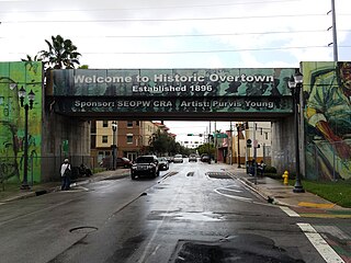
Overtown is a neighborhood of Miami, Florida, United States, just northwest of Downtown Miami. Originally called Colored Town in the Jim Crow era of the late 19th through the mid-20th century, the area was once the preeminent and is the historic center for commerce in the black community in Miami and South Florida. The Overtown Historic Folklife Village is in the area.

Beverly Glen Boulevard is one of six major routes that connect the Westside of Los Angeles to the San Fernando Valley (the other five are the San Diego Freeway, Sepulveda Boulevard, Topanga Canyon Boulevard, Laurel Canyon Boulevard, and Coldwater Canyon Avenue.
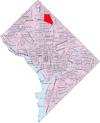
Manor Park is a neighborhood in Ward 4 of northwest Washington, D.C.

Spring Garden is a neighborhood in central Philadelphia, Pennsylvania, bordering Center City on the north. Spring Garden is a neighborhood that combines diverse residential neighborhoods and significant cultural attractions.
The geography of Minot, North Dakota, is treated extensively in this article.

Park West is a neighborhood of Greater Downtown, Miami, Florida. It is roughly bound by Biscayne Boulevard to the east, West (NW) First Avenue to the west, North (NE/NW) 7th Street to the south and Interstate 395 to the north. As of 2010, about 4,655 residents live in Park West. The neighborhood is named 'Park West' due to its location just west of Museum Park.

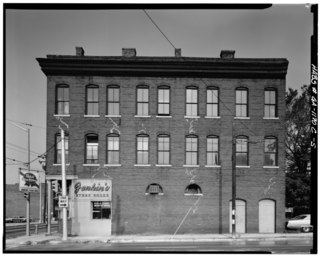
Downtown Minot is the central business district of Minot, North Dakota, located south of the Souris River in the Souris Valley. Downtown is the site of the first permanent settlement in Minot in 1886. Downtown is home to many of Minot's cultural sites of interest. It is also home to numerous galleries, stores and restaurants. The Minot Riverwalk traverses the downtown.
West Minot is a neighborhood in Minot, North Dakota, located in the Souris River Valley. It borders Oak Park to the South, North Hill to the North, Bel Air to the west and Nubbin Park to the east. The neighborhood is largely residential and there are no commercial thoroughfares, which run through the neighborhood. It received its name when at the time it was the westernmost neighborhood in Minot. Today, there are neighborhoods, such as Bel Air further west of here, but the area has retained the name West Minot. West Minot is home to the Quentin N. Burdick Jobs Center, Minot's Hebrew Cemetery and the West Minot Church of God.

North Hill is a neighborhood in Minot, North Dakota, one of three major areas of the city, others being The Valley and South Hill, It is located north of the Souris River, above the Souris River Valley. It is a primarily residential neighborhood, though there are industries and businesses in the area, primarily along North Broadway and 21st Ave NW. North Hill is also home to Minot International Airport.

South Hill is a neighborhood in Minot, North Dakota, one of three major areas in the city, others being North Hill and The Valley, it is located south of the Souris River, above the Souris River Valley. It is a primarily residential neighborhood, although there are commercial zones along South Broadway, 20th Ave SW, 37th Ave SW, and around the Dakota Square Mall.
Upper Brooklyn or Brooklyn Heights is a neighborhood on South Hill in Minot, North Dakota. The neighborhood consists of the sections of the Brooklyn Addition that are not part of Downtown Minot. The High Third neighborhood, the Lower Brooklyn neighborhood and the area around the Minot Municipal Auditorium, which were part of the Brooklyn Addition, are considered part of the downtown area. Upper Brooklyn is bordered by downtown and the BNSF railroad tracks to the north, Minot High School's Magic City Campus to the west, Eleventh Avenue SW to the south and South Broadway and Lower Brooklyn to the east. The neighborhood is approximately 0.46 square kilometers. The neighborhood is home to the Scandinavian Heritage Park and Jim Hill Middle School.
Piedmont Avenue is a major thoroughfare in Atlanta, beginning in Downtown Atlanta and ending at its continuation as Piedmont Road just before crossing under Interstate 85. Along the way, Piedmont Avenue passes through Midtown Atlanta where several historic properties are located on the street.
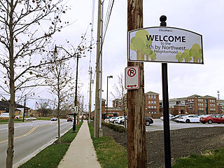
Fifth by Northwest is a neighborhood in Columbus, Ohio. Covering about 700 acres (280 ha), Fifth by Northwest is approximately bound by Glenn Avenue, Wyandotte Road, & Kinnear to the north, Third Avenue to the south, Kenny Road and Olentangy River Road to the east and Northstar Road to the west. Also sometimes referred to as 5XNW or the Tri-Village area, Fifth by Northwest is just north of Grandview Heights, northwest of the Harrison West neighborhood, and west of The Ohio State University.

