
Charles Lee Tilden Regional Park, also known as Tilden Park or Tilden, [], is a 2,079-acre (841 ha) regional park in the East Bay, part of the San Francisco Bay Area in California. It is between the Berkeley Hills and San Pablo Ridge. Its main entrance is near Kensington, Berkeley, and Richmond. The park is contiguous with Wildcat Canyon Regional Park.

Pacific Palisades is a neighborhood in the Westside region of Los Angeles, California, situated about 20 miles (32 km) west of downtown Los Angeles. Starting on January 7, 2025, the majority of Pacific Palisades was severely affected and destroyed by the Palisades Fire, a part of the wider, and ongoing, Southern California wildfires.

The East Bay Regional Park District (EBRPD) is a special district operating in Alameda County and Contra Costa County, California, within the East Bay area of the San Francisco Bay Area. It maintains and operates a system of regional parks which is the largest urban regional park district in the United States. The administrative office is located in Oakland.

Conejo Valley Botanic Garden is located in Thousand Oaks, California, and consists of a peak with vista views along with 15 hillside botanical gardens. It provides a teaching laboratory for what flora works and what does not work in the Conejo Valley.

Richmond station is an Amtrak intercity rail and Bay Area Rapid Transit (BART) station located in downtown Richmond, California. Richmond is the north terminus of BART service on the Orange Line and Red Line; it is a stop for Amtrak's Capitol Corridor, San Joaquins, and California Zephyr routes. The accessible station has one island platform for the two BART tracks, with a second island platform serving two of the three tracks of the Union Pacific Railroad Martinez Subdivision for Amtrak trains. It is one of two transfer points between BART and Amtrak, along with Oakland Coliseum station.

Wildcat Canyon Regional Park is a 2,789-acre (1,129 ha) East Bay Regional Park District (EBRPD) park bordering the city of Richmond in Contra Costa County in the San Francisco Bay Area of California. It includes a portion of Wildcat Canyon as well as a portion of the adjoining San Pablo Ridge, and is directly connected to the more heavily used Tilden Regional Park.

Alvarado Area is a subsection of Wildcat Canyon Regional Park in Richmond, California and is a National Historic Place. It is located at the mouth of Wildcat Canyon in the Alvarado Area section. Between 1909 and 1923, Alvarado Park was a private park that was owned and operated by local residents. In 1923, it was donated to the city of Richmond. Later it was admitted into the East Bay Regional Park District.
Sausal Creek, 3.1 miles (5.0 km) long, is one of the principal creeks in Oakland, California.

The East Shore and Suburban Railway (E&SR) was a formerly independent unit of the historic San Francisco Bay Area Key System which ran streetcar trains in Richmond, California, San Pablo, and El Cerrito. There were several lines with terminals at Point Richmond, North Richmond, the county line with Alameda County, what is now San Pablo, and Grand Canyon/East Richmond/Alvarado Park. Service to Oakland required a transfer to Oakland Traction Company trains at the County Line station and service to San Francisco required an additional transfer in Oakland. The systems were later consolidated into the Key System.
Marguerite Clayton was an American actress of the silent era. She appeared in more than 170 films between 1909 and 1928, many of which were westerns with Broncho Billy Anderson and Harry Carey.

Tote Du Crow was a film actor and circus performer who acted in many silent films during the early days of Hollywood.

Joshua Tree National Park is a national park of the United States in southeastern California, east of San Bernardino and Los Angeles and north of Palm Springs. It is named after the Joshua trees native to the Mojave Desert. Originally declared a national monument in 1936, Joshua Tree was redesignated as a national park in 1994 when the U.S. Congress passed the California Desert Protection Act. Encompassing a total of 795,156 acres – slightly larger than the state of Rhode Island – the park includes 429,690 acres of designated wilderness. Straddling San Bernardino and Riverside Counties, the park includes parts of two deserts, each an ecosystem whose characteristics are determined primarily by elevation: the higher Mojave Desert and the lower Colorado Desert. The Little San Bernardino Mountains traverse the southwest edge of the park.
Chicago Park is a residential and unincorporated historic agricultural community in Nevada County, California. It is located along Highway 174, with its center at the intersection of Mt. Olive Road. The neighborhood gets its name from its founding residents, who came from Chicago to California in the late 1800s to grow fruit, which was often shipped back to Illinois for consumption. Chicago Park is about 9 miles southeast of Grass Valley and about 3 miles north of Colfax.

The California Digital Newspaper Collection (CDNC) is a freely-available, archive of digitized California newspapers; it is accessible through the project's website. The collection contains over six million pages from over forty-two million articles. The project is part of the Center for Bibliographical Studies and Research (CBSR) at the University of California Riverside.

The California Nursery Company was established in Niles, California, and incorporated in 1884 by John Rock, R. D. Fox, and others. The nursery sold fruit trees, nut trees, ornamental shrubs and trees, and roses. It was responsible for introducing new hybrids created by such important West Coast breeders as Luther Burbank and Albert Etter.
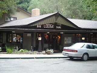
Big Sur Village is an unincorporated community in the Big Sur region, in Monterey County, California, United States. It is located along a 1-mile-long (1.6 km) stretch of Big Sur Coast Highway in the Big Sur Valley 24 miles (39 km) south of Carmel, California. The village contains the largest collection of shops and visitor services along the entire 71-mile (114 km) segment of California State Route 1 between Malpaso Creek near Carmel Highlands in the north and San Carpóforo Creek near San Simeon in the south. The population of the entire coastal region is about 1,463. The collection of small roadside businesses and homes is often confused with the larger region, also known as Big Sur. On March 6, 1915, United States Post Office granted the English-speaking residents' request to change the name of their post office from Arbolado to Big Sur. Caltrans also refers to the village as Big Sur.
Hassler Health Farm, formerly known as San Francisco Health Farm between 1927 and 1931, was a tuberculosis sanatorium for patients of the San Francisco Bay Area, owned by the City of San Francisco. It was located in a remote part of San Mateo County, California, in what is today San Carlos, until 1964. After the discovery of antibiotics, tuberculosis became a reduced threat, leading the building to be converted into a hospital for the poor. It was closed in 1972 and sat empty until 1985, when the buildings were demolished. Today, the grounds are home to the 366-acre Pulgas Ridge Open Space Preserve.
Yaqui Well is a historic spring located in Anza-Borrego Desert State Park in southeastern San Diego County, California in the United States about 21.4 mi (34.4 km) east of Warner Springs. The watering hole can be reached by a popular 1.64 mi (2.64 km) one-hour hiking trail starting at Tamarisk Grove Campground. The trail was described in the New York Times as a "flat, gentle hike—the kind that wraps around small, sloping hills, abuts a shallow canyon, and rewards its guests with an otherworldly view of the desert at the finale."

