The Gulf or Bay of Honduras is a large inlet of the Caribbean Sea, indenting the coasts of Belize, Guatemala, and Honduras. From north to south, it runs for approximately 200 km from Dangriga, Belize, to La Ceiba, Honduras.

The terrestrial fauna of the Cocos (Keeling) Islands is unsurprisingly depauperate, because of the small land area of the islands, their lack of diverse habitats, and their isolation from large land-masses. However, the fauna dependent on marine resources is much richer.

Atol das Rocas Biological Reserve is a biological reserve in Brazil. The reserve is located on the Rocas Atoll, an atoll 144 miles north east of the Brazilian coast. It was created in 1979 to protect nesting sea turtles and migratory seabirds.

The Bahia mangroves is a tropical ecoregion of the mangroves biome, and the South American Atlantic Forest biome, located in Northeastern Brazil. Its conservation status is considered to be critical/endangered due to global climate change and other factors.

The Gulf of Oman desert and semi-desert is a coastal ecoregion on the Persian Gulf and the Gulf of Oman in Oman and the United Arab Emirates at the northeastern tip of the Arabian Peninsula. The climate is hot and dry, with gravelly plains and savanna with thorny acacia trees inland from the coast. Along the coast there are mixture of habitats that include mangrove swamps, lagoons and mudflats. The mangrove areas are dominated by Avicennia marina and the savanna by Prosopis cineraria and Vachellia tortilis. Masirah Island is an important breeding area for the loggerhead sea turtle and other sea turtles also occur here, as well as a great variety of birds, some resident and some migratory. There are some protected areas, but in general the habitats have been degraded by the grazing of livestock, especially camels and goats; they are also at risk from oil spills, off-road driving and poaching.

Half Moon Caye is an island and natural monument of Belize located at the southeast corner of Lighthouse Reef Atoll. This natural monument was the first nature reserve to have been established in Belize under the National Park Systems Act in 1981 and first marine protected area in Central America. This is also Belize's oldest site of wildlife protection since it was first designated as a bird sanctuary in 1924 to protect the habitat of the red-footed booby birds.
The Belizean Coast mangroves ecoregion covers the brackish and salt-water habitats along the Caribbean Sea coast of Belize, and of Amatique Bay in Guatemala; small parts in the border with Mexico are also present on this ecoregion. The mangroves are partially protected from the open sea by the Belize Barrier Reef, and this ecoregion is distinct from the reef-based Belizean Reef mangroves ecoregion offshore. There is a large population of the vulnerable West Indian manatee in the area. It covers an area of around 2850 km2.
Cape Byron Marine Park is one of four marine parks in New South Wales, Australia, and is the most recently sanctioned. The Cape Byron Marine Park is located in Northern NSW and extends 37 kilometres (23 mi) from the Brunswick River to Lennox Head. The marine park extends out to 3 nautical miles which dictates the border between state and federal jurisdiction. The marine park covers an area of 220 square kilometres (85 sq mi) and includes a variety of marine terrain including beaches, rocky shores, open ocean and the tidal waters of the Brunswick River and its tributaries, the Belongil Creek and Tallow Creek. The Cape Byron Marine Park was declared in 2002 and the zoning plan was implemented in April 2006. Of the 15 distinct marine ecosystems identified within the Tweed-Moreton bioregion, the Cape Byron Marine Park supports 10 of these.

Lighthouse Reef is an atoll in the Caribbean Sea, the easternmost part of the Belize Barrier Reef and one of its three atolls, the other two being Turneffe Atoll and Glover's Reef. Lighthouse Reef is located about 80 kilometres (50 mi) southeast of Belize City. The atoll is of oblong shape, approximately 35 kilometres (22 mi) long from north to south, and about 8 kilometres (5.0 mi) wide. It forms a shallow sandy lagoon with an area of 120 square kilometres (46 sq mi) and a depth between 2 and 6 metres deep.

The Amazon–Orinoco–Southern Caribbean mangroves (NT1401) is an ecoregion along the coasts of Colombia, Venezuela, Guyana, Suriname, French Guiana and Brazil.

The Araya and Paria xeric scrub (NT1301) is an ecoregion in Venezuela that stretches along the Caribbean coast to the west of Trinidad, and that includes Margarita Island and some smaller islands. The ecoregion includes dune herbs, dry thorn scrubs and deciduous forests. The mountains on Margarita Island hold montane forests similar to those in the mainland coastal range. The beaches are used for breeding by sea turtles. Some endemic bird species are threatened with extinction by illegal capture for the pet trade. Deforestation and over-grazing by goats are also problems.
The South Taiwan monsoon rain forests ecoregion covers the southern tip of Taiwan, 200 km east of the mainland. The area is one of high biodiversity, due to its location between temperate and subtropical zones, its monsoon exposure, and its high altitude variation.

The Mesoamerican Gulf-Caribbean mangroves ecoregion covers the series of disconnected mangrove habitats along the eastern coast of Central America. These salt-water wetlands are found in river deltas, lagoons, and low-lying areas facing the Gulf of Mexico and Caribbean Sea, from Tampico, Mexico to central Panama. The mangroves are areas of high biodiversity and endemism. Many of the sites are protected as national parks or nature reserves.

The Bocas del Toro-San Bastimentos Island-San Blas mangroves ecoregion covers the mangrove habitats along the Caribbean Sea coast of Costa Rica and across the northern coast of Panama. An offshore reef and barrier islands of the region help protect the mangroves from destructive waves. The ecoregion has a high number of endangered and threatened species, including the loggerhead sea turtle, green sea turtle, and hawk's bill sea turtle.
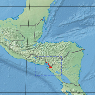
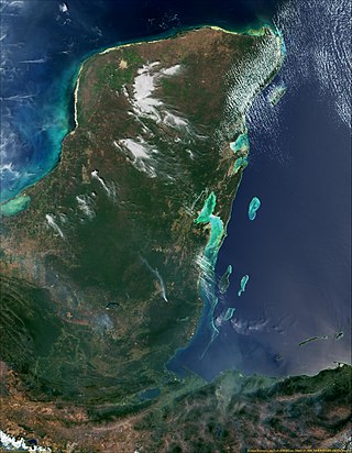
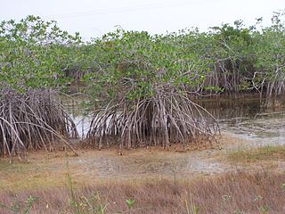
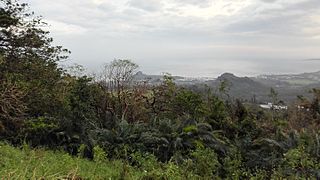
The Gulf of Fonseca mangroves ecoregion covers the brackish mangrove forests around the Gulf of Fonseca on the Pacific Ocean. The Gulf is the meeting point El Salvador, Honduras, and Nicaragua. The Gulf is one of the two primary nesting sites of the critically endangered Hawksbill turtle in the eastern Pacific. In the Honduras portion, there are seven nature reserves that collectively make up a RAMSAR wetland of international importance, providing protection for migratory birds, sea turtle, and fish.

The Lesser Antilles mangroves ecoregion covers the salt-water habitats along the coasts of the islands on the divide between the Caribbean Sea and the Atlantic Ocean. the included islands stretch from Anguilla in the north to the island of Grenada in the south. The species diversity of these small islands is less than that of the larger islands of the Greater Antilles with to the west, but endemism is high due to the relative isolation of the different islands.

The Mayan Corridor mangroves ecoregion covers the mangrove habitats along the Caribbean Sea coast of the state of Quintana Roo in southern Mexico and a narrow strip on the north of Belize. The region is named for the Maya Civilization archeological sites along the coast. Biodiversity in the area high due to the interactions of different environments - coastal lagoons, river estuaries, coral reefs, and barrier beaches. The ecoregion supports Mexico's largest population of crocodiles.

The Petenes mangroves ecoregion covers mangrove habitat along the Gulf of Mexico coast of southern Mexico, where Campeche state and Yucatan state meet, centering on the Celestun Lagoon inland from the barrier-island town of Celestún. Because the region has relatively little rainfall and no rivers feeding the lagoons, the freshwater to support the mangrove ecosystem springs from underground aquifers. The area is important for migratory birds, and as a nesting area for sea turtles. The area around the Celestun Lagoon is protected by the Ría Celestún Biosphere Reserve, a UNESCO Biosphere Reserve, and Los Petenes Biosphere Reserve in Campeche.

The Southern Dry Pacific Coast mangroves ecoregion covers a series of mangrove forests along the Pacific Ocean coast of Nicaragua and Costa Rica, from the southern margin of the Gulf of Fonseca to the Gulf of Nicoya near the border with Panama. Because the area is drier than the mangroves further south, evapotranspiration leaves some areas with higher salinity and even salt pans in the internal areas.

The Cayman Islands dry forests ecoregion covers about half of the Cayman Islands in the Caribbean Sea. The other half of the low-lying islands are mangroves. The dry forests of Grand Cayman have been heavily cleared or degraded for human development; the less populated islands have more intact wooded habitat.

