Related Research Articles
The National Register of Historic Places (NRHP) is the United States federal government's official list of districts, sites, buildings, structures, and objects deemed worthy of preservation for their historical significance or "great artistic value". A property listed in the National Register, or located within a National Register Historic District, may qualify for tax incentives derived from the total value of expenses incurred in preserving the property.

Starved Rock State Park is a state park in the U.S. state of Illinois, characterized by the many canyons within its 2,630 acres (1,064 ha). Located just southeast of the village of Utica, in Deer Park Township, LaSalle County, Illinois, along the south bank of the Illinois River, the park hosts over two million visitors annually, the most for any Illinois state park.

Writing-on-Stone Provincial Park is located about 100 kilometres (60 mi) southeast of Lethbridge, Alberta, Canada, or 44 kilometres (30 mi) east of the community of Milk River, and straddles the Milk River itself. It is one of the largest areas of protected prairie in the Alberta park system, and serves as both a nature preserve and protection for many First Nations (indigenous) rock carvings and paintings. The park is sacred to the Blackfoot and many other aboriginal tribes.

This is a list of properties and historic districts in Missouri on the National Register of Historic Places. There are NRHP listings in all of Missouri's 114 counties and the one independent city of St. Louis.

Samuels' Cave, also known as Brown's Cave, Pictured Cave, or Mystery Cave, is a prehistoric, naturally formed rock shelter located in La Crosse County, Wisconsin. The cave contains petroglyphs and pictographs from the Native Americans who lived in the area. It was listed on the National Register of Historic Places in 1991.

Washington State Park is a public recreation area covering 2,147 acres (869 ha) in Washington County in the central eastern part of the state of Missouri. It is located on Highway 21 about 14 miles (23 km) northeast of Potosi or 7 miles (11 km) southwest of DeSoto on the eastern edge of the Ozarks. The state park is noted for its Native American rock carvings and for its finely crafted stonework from the 1930s.
Arrow Rock State Historic Site is an open-air museum encompassing a geographic formation and a portion of the village of Arrow Rock, Missouri. The park is part of the Arrow Rock Historic District, a National Historic Landmark, and commemorates the history of the area as a key stop on the Santa Fe Trail.
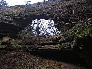
Natural Bridge State Park is a 530-acre (214 ha) state park of Wisconsin, United States, featuring Wisconsin's largest natural arch. Directly beneath the arch is the Raddatz Rockshelter, a rock shelter once used by Paleo-Indians and now listed on the National Register of Historic Places. The park is located southwest of Baraboo between the unincorporated communities of Leland and Denzer, in the town of Honey Creek.

The Modoc Rock Shelter is a rock shelter or overhang located beneath the sandstone bluffs that form the eastern border of the Mississippi River floodplain at which Native American peoples lived for thousands of years. This site is significant for its archaeological evidence of thousands of years of human habitation during the Archaic period in the Eastern United States. It is located on the northeastern side of County Road 7 southeast of Prairie du Rocher in Randolph County, Illinois, United States. It was declared a National Historic Landmark in 1961.

Silver Mound is a sandstone hill in Wisconsin where American Indians quarried quartzite for stone tools. Tools made from Silver Mound's quartzite have been found as far away as Kentucky. The oldest have been dated to around 11,000 years ago, so they provide clues about the first people in Wisconsin. Silver Mound Archeological District was declared a National Historic Landmark in 2006.
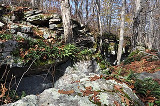
The Tomaquag Rock Shelters (RI-HP-1) are a prehistoric rock shelter site off Maxson Hill Road in Hopkinton, Rhode Island. The shelters are located under two east-facing granite outcrops in the valley drained by Tomaquag Brook. Nathan Kaye discovered the shelters in the late 1950s. Materials recovered from test excavations resulted in dating one shelter to 800 BC and the other to AD 800. Materials recovered include projectile points, stone knives, and evidence of stone tool construction. Both sites included evidence pointing to the presence of a fire pit.

Birch Coulee Battlefield in Renville County, Minnesota, United States, was the site of the Battle of Birch Coulee, the costliest military engagement for U.S. forces during the Dakota War of 1862. It is now a historic site with self-guided trails and markers interpreting the battle from both sides. Birch Coulee was nominated to the National Register of Historic Places for having state-level significance in military history, and was listed in 1973.

St. Paul's Episcopal Church in Chattanooga, Tennessee, is a downtown congregation of the Episcopal Church. It is one of the largest congregations in the Episcopal Diocese of East Tennessee.
Colorado Millennial Site is a prehistoric Paleo-Indian archaeological site located near Ruxton in the southeastern part of the U.S. state of Colorado, sitting along the border between Baca and Las Animas counties. It is also known by its site ID, 5LA1115, and the names Hackberry Springs and Bloody Springs.

Cañon Pintado, meaning painted canyon, is an archaeological site of Native American rock art located in the East Four Mile Draw, 10.5 miles (16.9 km) south of Rangely in Rio Blanco County, Colorado. Led by Ute guides, the Domínguez–Escalante expedition, Spanish missionaries in search of a route to California in 1776, passed through this region as they moved north and then west into Utah. The first Europeans to the area, they named it Cañon Pintado, meaning "painted canyon".

Seminole Canyon State Park and Historic Site is a state park in the U.S. state of Texas. It is located off U.S. Route 90, east of the Pecos River High Bridge, 9 miles (14 km) west of Comstock in Val Verde County. The park is conducive to camping, biking, bird watching, back packing and archeological study. Cave art and archeological artifacts date back to the earliest human habitation in the area. The park is part of the larger Seminole Canyon Archeological District on the National Register of Historic Places.

Grimes Point, in Churchill County, Nevada near Fallon, is a 720-acre (290 ha) archeological site that was listed on the U.S. National Register of Historic Places in 1972. It was listed for its potential to yield future information.

Petit Jean State Park is the oldest state park in Arkansas. It is located in the central northern part of the state, in western Conway County, atop Petit Jean Mountain, a ridge between the Ozark and Ouachita Mountains. One of the features the park is noted for is prehistoric rock art, some of which is accessible to park visitors via its hiking trails. A total of twelve such sites have been listed on the National Register of Historic Places for their importance. Most of the rock art has been dated to about 1500 CE, and is not obviously associated with habitation sites or other sites bearing evidence of other Native American activities.

Tainter Cave, also known as Tombstone Cave, is a dry sandstone cave in Crawford County, Wisconsin, in which prehistoric Native Americans carved petroglyphs and drew pictographs, including birds, men, deer, and abstract designs. With over 100 pictographs, the cave holds more than any other known site in Wisconsin. It is also notable as the first archaeological site recorded in the dark zone of a cave in the Upper Midwest.
The King Coulee Site is a prehistoric Native American archaeological site in Pepin Township, Minnesota, United States. It was listed on the National Register of Historic Places in 1994 for having state-level significance in the theme of archaeology. It was nominated for being a largely undisturbed occupation site with intact stratigraphy and numerous biofacts stretching from the late Archaic period to the Oneota period. This timeframe spans roughly from 3,500 to 500 years ago. The site yielded the oldest known evidence of domesticated plants in Minnesota: seeds dated to 2,500 years ago from the squash Cucurbita pepo.
References
- ↑ "National Register Information System". National Register of Historic Places . National Park Service. July 9, 2010.
- ↑ Robert A. Birmingham (December 1987). "National Register of Historic Places Multiple Property Documentation: Wisconsin Indian Rock Art Sites". National Park Service . Retrieved March 13, 2017.