BellePlaine | |
|---|---|
Village | |
 | |
| Country | |
| Parish | Saint Andrew |
| Subdivition into large tracts of land | 1767 |
| Time zone | UTC-4 (Eastern Caribbean Time Zone) |
| Area code | +1 246 |
Belleplaine is a village in the parish of Saint Andrew in Barbados.
BellePlaine | |
|---|---|
Village | |
| | |
| Country | |
| Parish | Saint Andrew |
| Subdivition into large tracts of land | 1767 |
| Time zone | UTC-4 (Eastern Caribbean Time Zone) |
| Area code | +1 246 |
Belleplaine is a village in the parish of Saint Andrew in Barbados.
The name Belleplaine means "Beautiful Plains", which is believed to be delivered from Coleridge family. [1]

The parish of Christ Church is one of eleven historic political divisions of Barbados. It has a land area of 57 km2 (22 sq mi) and is found at the southern end of the island. Christ Church has survived by name as one of the original six parishes created in 1629 by Governor Sir William Tufton.

Foul Bay refers to a bay, beach, and village in Saint Philip Parish, alongside the southeast coast of Barbados.
Six Cross Roads is an old village in the Parish of Saint Philip in Barbados.
Barclays Park is a 50-acre village in the parish of Saint Andrew in Barbados. Barclays Park was opened in 1966 by Queen Elizabeth II after being gifted to the Barbados government once independence was declared in 1966.
Bruce Vale is a populated place and former estate in the parish of Saint Andrew in Barbados.
Chalky Mount is a community in the parish of Saint Andrew in Barbados.

Cherry Tree Hill is a village in the parish of Saint Andrew in Barbados. It is approximately 850 ft. above sea level. It is believed that cherry trees lined the hill at some point, which has since been replaced by mahogany trees. The village overlooks the Scotland District.
Turner's Hall Wood is a national forest and nature reserve in the parish of Saint Andrew in Barbados.
The Wildey area of the Parish of Saint Michael located roughly 4 km east of Bridgetown, it lies on the border with the Parish of Christ Church. Normally a very busy area with the ABC Highway, Wildey is one of the main convergence points for vehicles travelling either towards the capital-city Bridgetown or towards points in northern Barbados. In recent years the area was reconfigured for traffic mitigation, the tri-directional split or fork in the highway formerly known as the "Wildey Y" was changed to only allow southbound traffic to turn left or right on to Wildey Road only. Northbound traffic must now travel on Wildey Road to Highway R road which brings traffic back to BET hill.
Chalky Mount is a rugged picturesque range of hills in Saint Andrew, Barbados, forming a jagged profile against the horizon when viewed from the east coast - commonly called Napoleon's Head.
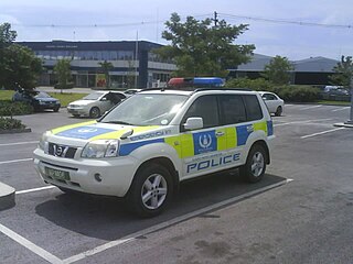
The Barbados Police Service (BPS), previously called the Royal Barbados Police Force (RBPF), is the law enforcement agency in Barbados, as established under the Police Act, Cap. 167. Richard Boyce is currently Commissioner of the Police.

The following outline is provided as an overview of and introduction to Barbados:

The Premier League is the top football league in Barbados. It was created in 1947 and is headed by the Barbados Football Association. Ten teams participate in this league. It is known as the Digicel Premier League for sponsorship reasons.

Bottom Bay is a bay located in Saint Philip, Barbados, with Palmetto Bay to the north, and Cave Bay, Crane Beach and Sam Lord's Castle to the south.

George Washington House in Barbados is a historic house where the future first U.S. President George Washington is alleged to have stayed in 1751.
Mile and a Quarter is a populated place in the parish of Saint Peter, Barbados.
Boscobelle is a populated place in the parish of Saint Peter, Barbados.
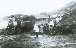
The Barbados Railway was a 38.6-kilometre (24.0 mi)-long narrow-gauge railway on Barbados with a gauge of initially 1,067 mm and later 762 mm. It had 98 bridges, very tight radii and a steep incline. It was used from 1883 to 1937, after it had gone several times through financial difficulties.
St. Andrew Lions FC is a Barbadian football club based in Belleplaine, Saint Andrew. As of 2019 it competes in the Barbados Premier League, the highest level of football in the nation.
13°15′N59°34′W / 13.250°N 59.567°W
| | This Barbados location article is a stub. You can help Wikipedia by expanding it. |