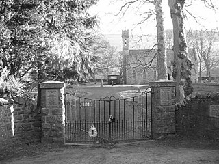
Heriot is a small village in the Moorfoot Hills southeast of Edinburgh, Scotland, within Eildon. The village comprises some 150 dwellings, spread over a geographical area of around 50 square miles (130 km2), most of which is moorland. Connected to the rest of the world primarily through the A7 road, Heriot had a railway station from 1849 until the branch line closures instigated by Beeching caused the track to be uplifted in the 1960s. The Scottish Parliament voted, in 2006, to reinstate the railway, but without a station at Heriot.
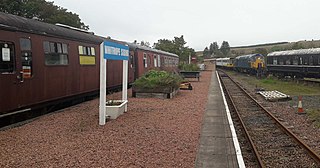
Whitrope Siding was a trailing short siding or spur off the "up" (southbound) line, an associated trailing cross-over between up and down lines, a pair of railway cottages and a signal box on the Waverley Line or Waverley Route. It was used as a goods loading bay. The site is now the home of the Whitrope Heritage Centre, as well as the current terminus of the heritage Border Union Railway.

Bemersyde House is a historic house in Roxburghshire, Scotland.
Cessford Burn is a small stream which eventually runs to meet the Kale Water and then joins the River Teviot, finally entering the River Tweed at Kelso, Scotland.

Wrae Tower is a ruined 16th-century stone tower house, located in the upper Tweed Valley in the Scottish Borders area of Scotland, and similarly south of the village of Broughton. The ruin is at grid reference NT115332, 3 km south-west of Drumelzier. Only a fragment of the north-east corner stair tower, around 9m high and 4m across, remains standing. A single jamb represents the north-west ground floor entrance to the tower and crowning the north-east wall is rough corbelling, which supports the remains of a parapet. The tower was probably built by the Tweedies of Drumelzier, who owned the surrounding lands since 1320.
Maxton is a hamlet and civil parish in Roxburghshire, Scotland, and part of the Scottish Borders region.

Chesters is a 1,565-acre (633 ha) country estate near Ancrum, located on the banks of the River Teviot in the Scottish Borders area of Scotland. The estate includes a listed house, workers houses, gardens and extensive grounds. National Grid Reference NT 60842 22512.

Dawyck Chapel, also known as Dalwick Church, is located within the Parish of Drumelzier in the Scottish Borders area of Scotland. The chapel lies within the Dawyck Botanic Gardens, an outstation or "regional garden" of the Royal Botanic Garden Edinburgh, some eight miles (13 km) south west of Peebles on the B712 and a similar distance south east of Biggar.
Redscarhead is a village in the Scottish Borders area of Scotland, off the A703, by the Eddleston Water, and close to Cringletie.

Kirkton is a village in the Scottish Borders area of Scotland, off the A6088, near Hawick. Grid Ref. NT5413.
Baddinsgill is a hamlet in the Scottish Borders area of Scotland. The Baddinsgill Reservoir is a few hundred metres north of the hamlet.

Talla Water is a river in the Scottish Borders area of Scotland, near Tweedsmuir. It feeds the Talla Reservoir, and is a tributary of the River Tweed. Above the reservoir are a series of waterfalls known as the Talla Linns.
Dryhope is a village in the Scottish Borders area of Scotland, by St. Mary's Loch, on the A708. Known for its rolling green hills and ample walking paths. Also home of St Mary's Loch, the largest natural loch in the Scottish Borders.
Leitholm is a village in the Scottish Borders area of Scotland, 4 miles (6.4 km) north-west of Coldstream, in the former county of Berwickshire.

Romanno Bridge is a village on the Lyne Water, on the A701, in the Scottish Borders area of Scotland.

Dawyck House is a historic house at Dawyck, in the parish of Drumelzier in the former Peeblesshire, in the Scottish Borders area of Scotland. The alternative name is 'Dalwick House'. Canmore ID 49816.
Eckford is a small village located between the larger towns of Kelso and Jedburgh in the Scottish Borders. The village is in close proximity to both the River Teviot and its tributary the Kale Water, and the A698 and the B6401 which run approximately parallel to the respective rivers.
Salenside is a village off the A7, on the Ale Water, near Ashkirk, in the Scottish Borders area of Scotland, in the former Selkirkshire. There was a Salenside Tower house, but nothing remains of it. Salenside Farm and Salenside Cottage exist. The placenames Selkirk and Salenside are related.

Megget Water is a river in the parish of Yarrow, Selkirkshire in the Scottish Borders area of Scotland. The Water rises at Broad Law (2,760 ft), passes through Megget Reservoir and empties into St Mary's Loch. Places in the vicinity include Cappercleuch, Craigierig, Cramalt Tower, the Glengaber Burn, Meggethead Farm.

Craigierig is a village on the Megget Reservoir, in the Scottish Borders area of Scotland, in the former Selkirkshire.