
Kilburn is a locality on the boundary of three London Boroughs: Camden, Brent and the City of Westminster. Kilburn High Road railway station lies 3.5 miles (5.6 km) north-west of Charing Cross.

Hampstead was a civil parish and metropolitan borough in London, England. It was an ancient parish in the county of Middlesex, governed by an administrative vestry. The parish was included in the area of responsibility of the Metropolitan Board of Works in 1855 and became part of the County of London in 1889. The parish of Hampstead became a metropolitan borough in 1900, following the London Government Act 1899, with the parish vestry replaced by a borough council. In 1965 the borough was abolished and its former area became part of the London Borough of Camden in Greater London.

Hampstead & Highgate was a parliamentary constituency covering the northern half of the London Borough of Camden which includes the village of Hampstead and part of that of Highgate.

Belsize Park is an affluent residential area of Hampstead in the London Borough of Camden, England.

West End Lane is a street in inner north-west London, England that runs for about one mile between Kilburn High Road to the south and Finchley Road to the north. Located in the London Borough of Camden, and the NW6 postal district, the street winds through West Hampstead with a mix of residential and commercial buildings. The three West Hampstead stations are all located on the road at the centre of the district of that name. In the north-east it today becomes Frognal Lane, although this stretch was once included as part of West End Lane. It also marks the western boundary of South Hampstead. It is not connected to the West End of Central London, which is around three miles to the south-east.

Belsize Park Gardens is a street in the Belsize Park area of Hampstead in London. Located in the London Borough of Camden, it is residential street featuring white stucco Victorian era buildings. It runs roughly southeastwards from Belsize Avenue in Belsize Village before terminating at a junction with Eton Avenue, England's Lane and Primrose Hill Road. The Grade II listed pub The Washington, dating from around 1865, is located at its eastern end.

Eton Avenue is a street in the Belsize Park area of Hampstead in North London. Located in the London Borough of Camden, it runs eastward from Swiss Cottage tube station to a junction with England's Lane, Primrose Hill Road and Belsize Park Gardens by The Washington pub. Fellows Road and Adelaide Road run parallel to the south of Eton Avenue.
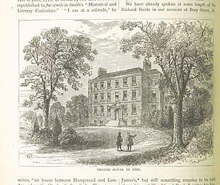
Belsize House was a historic residence in Belsize Park in what is today the London Borough of Camden. It was a country estate located south of Hampstead, which was then some distance away from the outskirts of the capital.

Belsize Lane is a street in the Belsize Park area of Hampstead in London. Located in the London Borough of Camden, it runs east to west from Haverstock Hill to Fitzjohns Avenue. While residential for much of the route, it also features a group of commercial properties that form the centre of Belsize Village. The Tavistock Clinic is located at its western end.

Hampstead High Street is located in the London Borough of Camden. It is the main high street for Hampstead Village and is part of the A502. Heading southeastwards from a junction with Heath Street and Holly Hill by Hampstead tube station it runs downhill and features a number of pubs, restaurants and shops before becoming Rosslyn Hill which connects it further on to Haverstock Hill, the whole stretch of which was one called Hampstead Road. Streets and alleys running off it include Flask Walk, Perrin Court and Prince Arthur Road.

Maresfield Gardens is a street in Hampstead. Located in the London Borough of Camden, it runs parallel to the west of Fitzjohns Avenue for much of its route before curving to join it at is southern end. It crosses Nutley Terrace and Netherhall Gardens. The Belsize Tunnel passes underneath the street. It primarily feature red brick buildings.
Netherhall Gardens is a street in Hampstead, in the London Borough of Camden. It connects Finchley Road with Fitzjohns Avenue, curving twice along its route and meeting Nutley Terrace and Maresfield Gardens. The short Netherhall Way connects it to Frognal. Belsize Tunnel carrying the Midland Main Line passes under the street.

Belsize Avenue is a street in the Belsize Park area of Hampstead. Located in the London Borough of Camden, it runs from Haverstock Hill westwards to a junction with Belsize Terrace and Belsize Park Gardens. It is the former carriageway approach to Belsize House, a country estate that occupied the area until it was demolished in 1853 to allow residential development. A number of houses in the street were built by William Willett around 1873.

Hampstead Hill Gardens is a street in Hampstead in the London Borough of Camden. It runs eastwards off the Rosslyn Hill stretch of the A502 road before looping round to join Pond Street to the south. The land was considered as a potential location for Hampstead Town Hall before a nearby site on Haverstock Hill was selected. The Hampstead Heath Tunnel of the North London Line passes under the street.

Loudoun Road is a street in the St John's Wood area of London. Most of its route is in the City of Westminster, but it crosses into the London Borough of Camden at its northern end in South Hampstead. It runs roughly parallel to Finchley Road to its east while Abbey Road, London is to the west. It runs north from Grove End Road, not far from St John's Wood tube station, and crosses or is joined by a number of streets including Marlborough Place, Carlton Hill and Boundary Road. It finishes at a roundabout junction with several streets including Belsize Road and Fairhazel Gardens. South Hampstead railway station is at the northern end of the street.

Adelaide Road is a street in London running east to west between Chalk Farm and Swiss Cottage. Located in the London Borough of Camden it is part of the longer B509 route which continues as Belsize Road through South Hampstead. The Belsize Park area of Hampstead is to its north while Primrose Hill is to the south. It runs parallel to Fellows Road and Eton Avenue. Along its route it meets or is crossed by several streets including Primrose Hill Road and Avenue Road. At its eastern end is Chalk Farm tube station at the junction with Haverstock Hill, which opened in 1907. It takes its name from Queen Adelaide, wife of William IV.

Primrose Hill Road is a street located in the London Borough of Camden. Running off Regent's Park Road in the centre of the Primrose Hill area it heads west before curving northwards, following for some of its route alongside the edge of Primrose Hill. After crossing Adelaide Road it terminates next to the The Washington pub in Belsize Park, at a junction with Eton Avenue, England's Lane and Belsize Park Gardens. Primrose Hill Tunnel carrying the West Coast Main Line passes underneath the street.

Priory Road is a street in Kilburn. Located in the London Borough of Camden it runs northwards from Belsize Road through South Hampstead crossing several streets including Abbey Road before finishing at a junction with Broadhurst Gardens, not far from West Hampstead tube station. It takes its name from the old Kilburn Priory located in the area until the dissolution of the monasteries under Henry VIII.

Broadhurst Gardens is a street in the London Borough of Camden running eastwards from West End Lane in West Hampstead and ending near to the Finchley Road. It forms the northern border of South Hampstead, and runs parallel to the Midland Main Line. It meets or is crossed by Priory Road, Fairhazel Gardens and Canfield Gardens.

Branch Hill is a street in Hampstead. Located in the London Borough of Camden it is named after a hill on Hampstead Heath and runs adjacent to the heath between Frognal Rise and West Heath Road. Branch Hill, then largely open countryside, was a favourite landscape of the artist John Constable and he painted it on a number of occasions. Branch Hill Pond is located close to the junction with West Heath Road, while it dried up in the early twentieth century recent efforts have been made to restore it.

