Loudoun Road

Last updated
Victorian era houses in the street. St. John's Wood Gothic, Loudoun Road, NW8 - geograph.org.uk - 2454992.jpg
Victorian era houses in the street.
South Hampstead station was known as Loudoun Road until 1922. South Hampstead Station - geograph.org.uk - 879897.jpg
South Hampstead station was known as Loudoun Road until 1922.
The former Blenheim Arms pub on the junction with Carlton Hill. Cafe Med, St Johns Wood, NW8 (6934376468).jpg
The former Blenheim Arms pub on the junction with Carlton Hill.

Loudoun Road is a street in the St John's Wood area of London. Most of its route is in the City of Westminster, but it crosses into the London Borough of Camden at its northern end in South Hampstead. It runs roughly parallel to Finchley Road to its east while Abbey Road, London is to the west. It runs north from Grove End Road, not far from St John's Wood tube station, and crosses or is joined by a number of streets including Marlborough Place, Carlton Hill and Boundary Road. It finishes at a roundabout junction with several streets including Belsize Road and Fairhazel Gardens. South Hampstead railway station is at the northern end of the street.

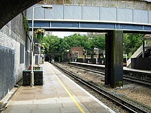
The road was laid out in the 1840s and 1850s, and takes its name from the Scottish landscape gardener John Claudius Loudon. [1] Initially only the southern section was named Loudon Street with the northern stretch known as Bridge Road after the road bridge carrying it across West Coast Main Line. By 1878 the whole street was known by the name and when a new railway station opened that year it was named after the street. Located at the entrance to the lengthy Primrose Hill Tunnel, it was known as Loudoun Road until its renaming as South Hampstead station in 1922. [2]

The street is primarily residential featuring a variety of architectural styles, including a number of the original buildings. The former Anglican Church of All Souls was built in 1864 and is now Grade II listed. [3] [4] A number of other buildings are listed. [5] [6] [7] [8] In the 1970s the Alexandra Road Estate was constructed on the western side of Loudoun Road and is now Grade II* listed. [9] [10]

Related Research Articles

<span class="mw-page-title-main">Belsize Park Gardens</span> Street in London, England

Belsize Park Gardens is a street in the Belsize Park area of Hampstead in London. Located in the London Borough of Camden, it is residential street featuring white stucco Victorian era buildings. It runs roughly southeastwards from Belsize Avenue in Belsize Village before terminating at a junction with Eton Avenue, England's Lane and Primrose Hill Road. The Grade II listed pub The Washington, dating from around 1865, is located at its eastern end.

<span class="mw-page-title-main">Carlton Vale</span> Street in London

Carlton Vale is a street that runs through Kilburn and Maida Vale in London. Some of its route forms the boundary between the City of Westminster to the south and the London Borough of Brent to the north. To the west the street continues as Kilburn Lane through Queen's Park, while to the east it becomes Carlton Hill running into St. John's Wood. Carlton Vale crosses or meets several roads including Kilburn Park Road, Cambridge Road and Randolph Avenue.

<span class="mw-page-title-main">Gloucester Avenue</span> Street in London, England

Gloucester Avenue is a street in the Primrose Hill area of London, England. Located in the London Borough of Camden, it is a residential road featuring many nineteenth century properties including several pubs as well as the neo-Georgian Cecil Sharp House. For much of its route it runs adjacent to the West Coast Main Line out of Euston Station.

<span class="mw-page-title-main">Norland Square</span> Garden square in London

Norland Square is a garden square in the Notting Hill area of London. Located in the Royal Borough of Kensington and Chelsea, runs northward from Holland Park Avenue to Queensdale Road. The mews street Norland Place runs eastwards of the Square.

<span class="mw-page-title-main">Well Walk</span> Street in London, England

Well Walk is a street in Hampstead, England located in the London Borough of Camden. It runs southwestwards from Hampstead Heath to Flask Walk which then continues on towards the centre of Hampstead Village around the Hampstead tube station. It takes its name from the historic Hampstead Wells.

<span class="mw-page-title-main">Eton Avenue</span> Street in London, England

Eton Avenue is a street in the Belsize Park area of Hampstead in North London. Located in the London Borough of Camden, it runs eastward from Swiss Cottage tube station to a junction with England's Lane, Primrose Hill Road and Belsize Park Gardens by The Washington pub. Fellows Road and Adelaide Road run parallel to the south of Eton Avenue.

<span class="mw-page-title-main">Well Road</span> Street in London, England

Well Road is a street in Hampstead, England located in the London Borough of Camden. It runs westwards from Hampstead Heath to New End Square. Well Walk runs parallel to its south and the two are linked by Wells Passage. When the Hampstead Wells were in existence, a large pump room and assembly room were located on Well Walk, with the water supplied from the headspring on Well Road.

<span class="mw-page-title-main">New End Square</span> Square in Hampstead, London

New End Square is a square in Hampstead, located in the London Borough of Camden. It dates back to the early eighteenth century when it was located close to the Hampstead Wells spa on the adjacent Well Walk. Despite its name it is not rectangular. At its northern end is the Old White Bear pub dating back to 1704, on the corner with Well Road. Its southern end is at the junction between Flask Walk and Well Walk. New End street curls off from one corner of the square, eventually heading west to Heath Street.

<span class="mw-page-title-main">Flask Walk</span> Street in London, England

Flask Walk is a street in Hampstead in the London Borough of Camden. It runs eastwards from Hampstead High Street to a junction with Well Walk and New End Square. It is primarily residential but the western end of the street is a pedestrianised alley featuring commercial properties. Hampstead tube station is located close to the junction with the High Street.

<span class="mw-page-title-main">Pond Street, Hampstead</span> Street in London, England

Pond Street is located in Hampstead in the London Borough of Camden. It runs eastwards from Rosslyn Hill to South End Green, located in the old "South End" of the settlement. The street takes its name from an ancient pond at South End Green, a source of the River Fleet, and has been known by this name since at least 1678. The pond survived into the Victorian era.

<span class="mw-page-title-main">Hampstead Way</span> Street in London, England

Hampstead Way is a street at the northern edge of Hampstead. It is located primarily in the London Borough of Barnet although its southern end forms a border with the London Borough of Camden in which the rest of Hampstead is located. In the south it is part of the old hamlet of North End, which marked the northern boundary of Hampstead, but then curves northwards and follows the edge of Hampstead Heath into Golders Green and Hampstead Garden Suburb. The southern end leads off North End Way.

<span class="mw-page-title-main">South End Road</span> Street in London, England

South End Road is located in Hampstead in the London Borough of Camden. It takes its name from the old "South End" of Hampstead. It runs southwards from the junction with East Heath Road and Downshire Hill alongside the southern edge of Hampstead Heath until reaching South End Green where it meets Pond Street and two roads running off east towards Gospel Oak. South Hill Park street runs north towards Hampstead Ponds. Keats Grove runs off the road and forms a triangle with Downshire Hill noted for its surviving Regency architecture.

<span class="mw-page-title-main">Hampstead Grove</span> Street in London, England

Hampstead Grove is a street in Hampstead in the London Borough of Camden. It heads northwards from Holly Hill running towards Hampstead Heath, but curving back towards Lower Terrace which connects it to the Heath. It runs roughly parallel to Heath Street to its east. It takes its name from the groves of trees that marked the landscape.

<span class="mw-page-title-main">Holly Hill, Hampstead</span> Street in London, England

Holly Hill is a street in Hampstead in the London Borough of Camden. It runs northwards from a junction with Hampstead High Street and Heath Street, Hampstead heading uphill to a grassy triangle named Holly Bush Hill where it meets Windmill Hill and Hampstead Grove by the entrance to Fenton House. It takes its name from a grove of holly bushes which stood on the hill until the 1940s. In the eighteenth century it was known as Cloth Hill, likely because local laundresses using Hampstead Wells hung their clothes out on the Holly Bushes to dry. Holly Mount turns eastwards off the street and forms a cul-de-sac, although there are steps linking it to Heath Street below. Holly Mount contains The Holly Bush pub, which was once linked to the nearby assembly rooms. Notable residents of Holly Hill have included the artists George Romney and Derek Hill, both commemorated with blue plaques. A number of properties are now Grade II listed. Romney's House at 5 Holly Bush Hill is Grade I listed. Running uphill to the west is Mount Vernon which also features notable historic properties and Holly Walk.

<span class="mw-page-title-main">Hampstead Hill Gardens</span> Street in London

Hampstead Hill Gardens is a street in Hampstead in the London Borough of Camden. It runs eastwards off the Rosslyn Hill stretch of the A502 road before looping round to join Pond Street to the south. The land was considered as a potential location for Hampstead Town Hall before a nearby site on Haverstock Hill was selected. The Hampstead Heath Tunnel of the North London Line passes under the street.

<span class="mw-page-title-main">Adelaide Road</span> Street in London

Adelaide Road is a street in London running east to west between Chalk Farm and Swiss Cottage. Located in the London Borough of Camden it is part of the longer B509 route which continues as Belsize Road through South Hampstead. The Belsize Park area of Hampstead is to its north while Primrose Hill is to the south. It runs parallel to Fellows Road and Eton Avenue. Along its route it meets or is crossed by several streets including Primrose Hill Road and Avenue Road. At its eastern end is Chalk Farm tube station at the junction with Haverstock Hill, which opened in 1907. It takes its name from Queen Adelaide, wife of William IV.

<span class="mw-page-title-main">Priory Road</span> Street in London

Priory Road is a street in Kilburn. Located in the London Borough of Camden it runs northwards from Belsize Road through South Hampstead crossing several streets including Abbey Road before finishing at a junction with Broadhurst Gardens, not far from West Hampstead tube station. It takes its name from the old Kilburn Priory located in the area until the dissolution of the monasteries under Henry VIII.

<span class="mw-page-title-main">Broadhurst Gardens</span> Street in London

Broadhurst Gardens is a street in the London Borough of Camden running eastwards from West End Lane in West Hampstead and ending near to the Finchley Road. It forms the northern border of South Hampstead, and runs parallel to the Midland Main Line. It meets or is crossed by Priory Road, Fairhazel Gardens and Canfield Gardens.

<span class="mw-page-title-main">Branch Hill, Hampstead</span> Street in London, England

Branch Hill is a street in Hampstead. Located in the London Borough of Camden it is named after a hill on Hampstead Heath and runs adjacent to the heath between Frognal Rise and West Heath Road. Branch Hill, then largely open countryside, was a favourite landscape of the artist John Constable and he painted it on a number of occasions. Branch Hill Pond is located close to the junction with West Heath Road, while it dried up in the early twentieth century recent efforts have been made to restore it.

<span class="mw-page-title-main">Belsize Road</span> Street in London

Belsize Road is a street in the London Borough of Camden. It runs west to east from Kilburn High Road to close to Finchley Road in the Swiss Cottage area of Hampstead. It is part of the B509 route which continues eastwards as Adelaide Road to Chalk Farm tube station. Despite its name it is located to the west of Belsize Park in the South Hampstead area. Much of its route runs parallel to the Midland Main Line and Kilburn High Road station is at its eastern end. It meets a number of streets including Loudoun Road, Abbey Road and Priory Road.

References

Bibliography