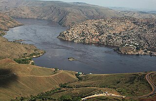
Matadi is the chief sea port of the Democratic Republic of the Congo and the capital of the Kongo Central province. It has a population of 245,862 (2004). Matadi is situated on the left bank of the Congo River, 148 km (92 mi) from the mouth and 8 km (5.0 mi) below the last navigable point before the rapids that make the river impassable for a long stretch upriver. It was founded by Sir Henry Morton Stanley in 1879.

Kasaï-Occidental was one of the eleven provinces of the Democratic Republic of the Congo between 1966 and 2015, when it was split into the Kasaï-Central and the Kasaï provinces.
Beni, sometimes El Beni, is a northeastern department of Bolivia, in the lowlands region of the country. It is the second-largest department in the country, covering 213,564 square kilometers, and it was created by supreme decree on November 18, 1842 during the administration of General José Ballivián. Its capital is Trinidad.

Kisangani is the capital of Tshopo province in the Democratic Republic of the Congo. It is the third largest urbanized city in the country and the largest of the cities that lie in the tropical woodlands of the Congo.
Kole is a rather remote town in central Democratic Republic of the Congo on the Lukenie River. It is the administrative center of the Kole Territory, which in turn is part of Sankuru Province. Kole is sometimes designated "Kole Sur Lukenie" to distinguish it from other "Koles" in the DRC.

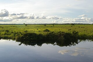
The Lukenie River is a river in the central Congo basin of the Democratic Republic of the Congo (DRC).

Lusambo is a territory in and capital of Sankuru province, Democratic Republic of the Congo. The town lies north of the confluence of the Sankuru River and the Lubi River. Lusambo is served by Lusambo Airport.

Chiefdoms and sectors of the Democratic Republic of the Congo are the fourth-level administrative divisions of the Democratic Republic of the Congo.
Moba Territory is a territory in the Tanganyika Province of the Democratic Republic of the Congo. The administrative center is Moba port. The territory has an estimated area of 24,500 square kilometres (9,500 sq mi) and a population of almost 610,000.

Sankuru is one of the 26 provinces of the Democratic Republic of the Congo. Its capital is Lusambo.

Mai-Ndombe District was a district of pre-2015 Bandundu Province in the Democratic Republic of the Congo. In 2015, it was merged with Plateaux District, all in pre-2015 Bandundu Province, to form the new Mai-Ndombe Province.
The Lubefu River is a tributary of the Sankuru River, which in turn is a tributary of the Kasai River in the Democratic Republic of the Congo.
Lubefu is a community in Sankuru province of the Democratic Republic of the Congo. It is the administrative center of the Lubefu territory.
Bena Kamba is a community on the Lomami River in Maniema province of the Democratic Republic of the Congo.
The Zappo Zap were a group of Songye people from the eastern Kasai region in what today is the Democratic Republic of the Congo. They acted as allies of the Congo Free State authorities of the King of the Belgians, while trading in ivory, rubber and slaves. In 1899 they were sent out by the colonial administration to collect taxes. They massacred many villagers, causing an international outcry.
Bena Makima is a community in the Democratic Republic of the Congo. It is on the right bank of the Kasai River, a few kilometers downstream from the point where the Lulua River enters the Kasai. It is at the highest navigable point on the Kasai in the dry season.
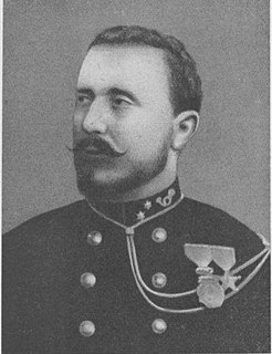
Paul-Amedee Le Marinel (1858–1912) was an American-born officer in the Belgian army who became an explorer and administrator in the Congo Free State. He was best known for his expedition to Katanga in 1891.
Luozi is a community in Kongo Central province of the Democratic Republic of the Congo. It is the seat of the Luozi Territory within Cataractes District. As of 2012 the town's population was estimated to be 13,855.

Katanda Territory is one of five territories which, along with the city of Mbuji-Mayi, constitute the current Congolese province of Kasai-Oriental. The Democratic Republic of the Congo (DRC) is made up of 192 territories and 20 cities which are grouped in 26 provinces including Kinshasa, the capital city. Katanda Territory is sectioned into four sectors: Baluba-Lubilanji, Mutwayi, Nsangu, and Tshitolo. The territory is also endowed with three towns. Katanda Town is the headquarters of both Katanda Territory and Baluba-Lubilanji Sector as well; this town is located on the top of the hill in the Bena Nshimba Grouping. Tshala town, in the Bakwa Ndaba Grouping, is also famous because of its power station on the Tshala River that supplies power to Mbuji-Mayi city and its neighborhoods. So, Tshitenge Town which is well known for its diamond businesses is in the Bena Nshimba Grouping.

The Allied Democratic Forces insurgency is an ongoing conflict waged by the Allied Democratic Forces in Uganda and the Democratic Republic of the Congo, against the governments of those two countries. The insurgency began in 1995, intensifying in 2013, resulting in hundreds of deaths. The ADF is known to currently control a number of hidden camps which are home to about 2,000 people; in these camps, the ADF operates as proto-state with "an internal security service, a prison, health clinics, and an orphanage" as well as schools for boys and girls.
