Bendigo Botanic Gardens

Last updated

The Arch of Triumph at the Bendigo Botanic Gardens WhiteHillsWarMemorial.JPG
The Arch of Triumph at the Bendigo Botanic Gardens

The Bendigo Botanic Gardens, formerly known as the White Hills Botanical Garden, are Australian botanic gardens in the Bendigo suburb of White Hills, Victoria. The gardens are one of regional Victoria's earliest botanic gardens. [1]

The Bendigo Botanic Gardens were founded in 1857 after land had been reserved for the site on the 1854 plan of Bendigo. [2]

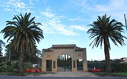
In 1925, an Arch of Triumph was erected on the Napier Street (Midland Highway) entrance as a memorial to the fallen from the First World War. [3]

Related Research Articles

<span class="mw-page-title-main">City of Greater Bendigo</span> Local government area in Victoria, Australia

The City of Greater Bendigo is a local government area in Victoria, Australia, located in the central part of the state. It covers an area of 3,000 square kilometres (1,200 sq mi) and, in August 2021, had a population of 121,470. It includes the city of Bendigo and the towns of Axedale, Elmore, Heathcote, Marong, Raywood and Strathfieldsaye. It was formed in 1994 from the amalgamation of the former City of Bendigo with the Borough of Eaglehawk, Shire of Strathfieldsaye, Shire of Huntly and parts of the Rural City of Marong and Shire of McIvor. It is the state’s third largest economy base and is considered a service and infrastructure centre for north central Victoria. The city is surrounded by 40,000 hectares of regional, state and national parkland.

<span class="mw-page-title-main">HM Prison Bendigo</span>

HM Prison Bendigo was a medium security prison facility located in Bendigo, Victoria, Australia. Constructed in the early 1863, the prison officially closed in 2004, and has since been converted into Ulumbarra Theatre, one of the city's largest performing arts venues. Construction on the prison began in the late 1850s and was originally housed both male and female inmates before they were relocated in 1896.

<span class="mw-page-title-main">Anglican Diocese of Bendigo</span> Diocese of the Anglican Church of Australia

The Anglican Diocese of Bendigo is a diocese of the Anglican Church of Australia. It is situated in the Bendigo region of the state of Victoria, Australia. Its geographic remit extends from that part of Victoria that lies north of the Great Dividing Range and west of the Goulburn River to the border with the state of South Australia. The diocesan cathedral is St Paul's Cathedral, Bendigo. The diocese was separated from the Diocese of Melbourne in 1902, with Henry Archdall Langley installed as the first bishop. The current bishop, Matt Brain, was installed on 17 February 2018.

The Bendigo School of Mines was established in Bendigo, Australia in 1873 to provide technical education, predominantly for the mining industry.

<span class="mw-page-title-main">County of Bendigo</span> Cadastral in Victoria, Australia

The County of Bendigo is one of the 37 counties of Victoria which are part of the cadastral divisions of Australia, used for land titles. It includes the city of Bendigo. It is bounded by the Campaspe River in the east, and the Loddon River in the west. The county was proclaimed in 1869.

<span class="mw-page-title-main">Electoral district of Bendigo East</span> State electoral district of Victoria, Australia

Bendigo East is an electoral district of the Legislative Assembly in the Australian state of Victoria. It covers an area of 2,711 square kilometres (1,047 sq mi) covering the part of the city of Bendigo east of the Yungera railway line and surrounding rural areas to the north, east and south. It includes the Bendigo suburbs of East Bendigo, Epsom, Flora Hill, Junortoun, Kennington, Quarry Hill, Spring Gully, Strathdale, Strathfieldsaye and White Hills, and the surrounding towns of Axedale, Goornong, Huntly, Mandurang, Raywood and Sedgwick. It also includes parts of the localities of Eaglehawk, Elmore, Golden Square and Ravenswood, and the Bendigo campus of La Trobe University. It lies within the Northern Victoria Region of the upper house, the Legislative Council.

<span class="mw-page-title-main">Shire of Huntly</span> Local government area in Victoria, Australia

The Shire of Huntly was a local government area immediately to the northeast of the regional city of Bendigo, Victoria, Australia. The shire covered an area of 878 square kilometres (339.0 sq mi), and existed from 1866 until 1994.

<span class="mw-page-title-main">Shire of Strathfieldsaye</span> Local government area in Victoria, Australia

The Shire of Strathfieldsaye was a local government area immediately to the east and southeast of the regional city of Bendigo, Victoria, Australia, and included the eastern suburbs of Bendigo's metropolitan area. The shire covered an area of 601.34 square kilometres (232.2 sq mi), and existed from 1861 until 1994.

<span class="mw-page-title-main">City of Bendigo</span> Local government area in Victoria, Australia

The City of Bendigo was a local government area covering the central area and inner western suburbs of the regional city of Bendigo, Victoria, Australia. The city covered an area of 32.53 square kilometres (12.6 sq mi), and existed from 1855 to 1994.

<span class="mw-page-title-main">Borough of Eaglehawk</span> Local government area in Victoria, Australia

The Borough of Eaglehawk was a local government area which covered the northwestern suburbs of the regional city of Bendigo, Victoria, Australia. The borough covered an area of 14.54 square kilometres (5.6 sq mi), and existed from 1862 until 1994.

Weeroona College Bendigo is an Australian co-educational secondary school, catering for students in years 7 to 10, located in White Hills, a suburb of Bendigo, Victoria.

<span class="mw-page-title-main">Bendigo TAFE</span>

Bendigo TAFE is a regional provider of vocational education, training and assessment services, located in northern and central Victoria, Australia. The institute has been in operation in various guises since 1854. The institute was known as the Loddon Campaspe Institute of TAFE from 1987 to 1990, Bendigo Regional Institute of TAFE (BRIT) from 1990 to 2009, before becoming Bendigo TAFE in 2009.

<span class="mw-page-title-main">White Hills, Victoria</span> Suburb of Bendigo, Victoria, Australia

White Hills is a suburb of the city of Bendigo in central Victoria, Australia. It is located four kilometres immediately north-east of the city centre between North Bendigo and East Bendigo.

<span class="mw-page-title-main">Bendigo Post Office</span> Building in Victoria, Australia

The Bendigo Post Office is a building on Pall Mall in Bendigo, a provincial city in the Australian state of Victoria. The post office backs onto and is partly surrounded by Rosalind Park. The building was built between 1883 and 1887 by the contractors McCulloch and McAlpine and designed by Public Works architect George W. Watson in the Second Empire architectural style. The building shares a great deal with its neighbouring building, the Bendigo Law Courts, and had the same builder and designer and was built at around the same time.

<span class="mw-page-title-main">Bendigo Art Gallery</span> Art gallery in Victoria, Australia

Bendigo Art Gallery is an Australian art gallery located in Bendigo, Victoria. It is one of the oldest and largest regional art galleries.

The electoral district of Bendigo was an electorate of the Victorian Legislative Assembly in the Australian state of Victoria. Centred on the city of Bendigo, the district was formed when the electorates of Bendigo East and Bendigo West were merged into a single district in 1927. Bendigo was abolished in 1985 when it was once again split into separate East and West districts.

<span class="mw-page-title-main">Mandurang</span> Suburb of City of Greater Bendigo, Victoria, Australia

Mandurang is a locality in the City of Greater Bendigo, in the Australian state of Victoria. It grew and developed as a goldfield settlement and logging locality, though today mostly consists of small farms and wineries. The name is derived from an Aboriginal word meaning black cicada.

<span class="mw-page-title-main">Langley Hall (Bendigo)</span> Mansion built in 1904

Langley Hall is a mansion in the Federation architectural style, designed by the prolific Bendigo architects William Charles Vahland (1828–1915) and John Beebe (1866–1936). Built in 1904 as the Vahland-Beebe architectural partnership's largest commission, Langley Hall is located in Bendigo, Victoria, Australia. The mansion is part of the 2.5-acre Langley Estate situated on the corners of Napier Street, Lyons Street and Dundas Street in White Hills and "remains one of the most prominent landmark buildings of the city".

<span class="mw-page-title-main">Bendigo Creek</span>

Bendigo Creek is a seasonal stream, or creek, in North Central Victoria, Australia. The city of Bendigo is named for the creek and valley in which it was founded in 1851. Gold was officially discovered on Bendigo Creek in late October 1851, transforming the area in less than a year from a secluded bushland to a scene which "beggared description" as tens of thousands of men, women and children came to the area during the gold rush at Bendigo Creek in 1852.

<span class="mw-page-title-main">Charing Cross (Bendigo)</span> Major junction centrally located in the city of Bendigo, Victoria, Australia

Charing Cross is a major junction centrally located in the city of Bendigo, Victoria, Australia. It is the intersection, or crossing point, of four of Bendigo's main streets: High Street, View Street, Pall Mall and Mitchell Street. As the Midland Highway, one of Bendigo's main thoroughfares, passes through Charing Cross, the highway is named High Street to the south-west and Pall Mall to the north-east of Charing Cross.

References

  1. City of Bendigo website.
  2. Heritage Council website.
  3. "BENDIGO". The Age . No. 21, 884. Victoria, Australia. 25 May 1925. p. 11. Retrieved 16 February 2021 via National Library of Australia.

36°43′26″S144°18′27″E / 36.72389°S 144.30750°E / -36.72389; 144.30750