
Tanzania comprises many lakes, national parks, and Africa's highest point, Mount Kilimanjaro. Northeast Tanzania is mountainous, while the central area is part of a large plateau covered in grasslands. The country also contains the southern portion of Lake Victoria on its northern border with Uganda and Kenya.
Shady Grove is a census-designated place (CDP) in McIntosh County, Oklahoma, United States. The population was 199 at the 2010 census, a decrease of 14.4 percent from 229 in 2000. This is not to be confused with the similarly-named Shady Grove in Cherokee County, or the Shady Grove in Pawnee County.

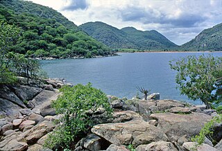
Chizumulu Island is the smaller of two islands in Lake Malawi, the larger being the nearby Likoma island, which together make up the Likoma District. Both these islands lie just a few kilometres from Mozambique and are entirely surrounded by Mozambican territorial waters, but they belong to Malawi. They are therefore exclaves of Malawi. This came about because the islands were colonised by Anglican missionaries spreading east from Nyasaland, rather than by the Portuguese who colonised Mozambique. The British originally claimed the entire Lake Nyasa/Lake Malawi, but in 1954 signed an agreement with Portugal, which recognized the centre of the lake as the boundary between their holdings and Mozambique, and making these islands an enclave.
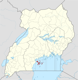
The Ssese Islands are an archipelago of eighty-four islands in the northwestern part of Lake Victoria in Uganda. The islands are coterminous with the Kalangala District in southern Central Uganda, which does not have any territory on mainland Uganda.
This is a list of extreme points in Antarctica.
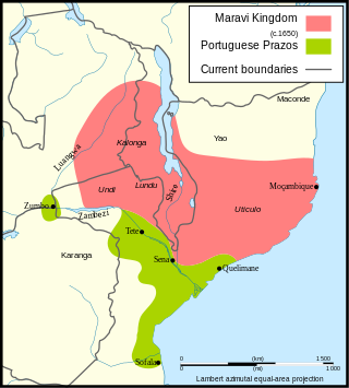
Maravi was a kingdom which straddled the current borders of Malawi, Mozambique, and Zambia, in the 16th century. The present-day name "Maláŵi" is said to derive from the Chewa word malaŵí, which means "flames". "Maravi" is a general name of the peoples of Malawi, eastern Zambia, and northeastern Mozambique. The Chewa language, which is also referred to as Nyanja, Chinyanja or Chichewa, and is spoken in southern and central Malawi, in Zambia and to some extent in Mozambique, is the main language that emerged from this empire.

The Bazaruto Archipelago is a group of six islands in Mozambique, near the mainland city of Vilankulo. It comprises the islands of Bazaruto, Benguerra, Magaruque, Banque, Santa Carolina and Shell. Nyati Island is located further south.
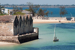
The Island of Mozambique lies off northern Mozambique, between the Mozambique Channel and Mossuril Bay, and is part of Nampula Province. Prior to 1898, it was the capital of colonial Portuguese East Africa. With its rich history and sandy beaches, the Island of Mozambique is a UNESCO World Heritage Site and one of Mozambique's fastest-growing tourist destinations. It has a permanent population of approximately 14,000 people and is served by nearby Lumbo Airport on the Nampula mainland. The name of the country, Mozambique, is derived from the name of this island.

Bazaruto is a sandy island located approximately 80 kilometres (50 mi) southeast of the mouth of the Save River, Mozambique. It is the largest island in the Bazaruto Archipelago and in the Bazaruto National Park.
Likoma District is the least populous district of Malawi, which consists of two separate exclaves of Malawi situated within Mozambican waters in Lake Malawi. It consists of two main islands, Likoma and Chizumulu. It is a district in the Northern Region of Malawi. The capital is Likoma.
Auhah Island is a small island belonging to Kuwait. It is 800 metres (2,625 ft) long by 540 metres (1,772 ft) wide, which corresponds to an area of about 34 hectares, and is located 4 km (2 mi) south-east of Failaka Island, and 33 km (21 mi) from Salmiya on the mainland. Apart from a lighthouse and a small heliport, the island is uninhabited.
Magaruque Island, formerly Ilha Santa Isabel, is part of the Bazaruto Archipelago, off the coast of Mozambique. It is located 5.6 km south of Benguerra Island, and 9.9 km east of Ponta Chuè on the mainland of Mozambique.
Benguerra Island Airport is an airport on Benguerra Island, Mozambique. The nearest major airport is Vilankulo Airport on the mainland of Mozambique.

Inhassoro District is a district of Inhambane Province in south-east Mozambique. The district is located at the northeast of the province, and borders with Govuro District in the north, Vilanculos District in the southeast, Massinga District in the south, Funhalouro District in the southwest, and with Mabote District in the west. In the east, the district is bounded by the Indian Ocean. The area of the district is 4,480 square kilometres (1,730 sq mi). It has a population of 48,537 as of 2007.
Mutarara, or Nhamayabué, is a town in Mozambique. It lies on the north bank of the Zambezi River.

The Goolwa Barrages comprise five barrage structures in the channels separating Lake Alexandrina from the sea at the mouth of the River Murray and the Coorong in South Australia. They were constructed principally to reduce salinity levels in the lower reaches of the River Murray, Lake Alexandrina and Lake Albert, but also to stabilise the river level, for both upstream irrigation and pumping.

Greece is a country of the Balkans, in Southeastern Europe, bordered to the north by Albania, North Macedonia and Bulgaria; to the east by Turkey, and is surrounded to the east by the Aegean Sea, to the south by the Cretan and the Libyan seas, and to the west by the Ionian Sea which separates Greece from Italy.

The Bazaruto Archipelago National Park (BANP) is a protected area in the Inhambane Province of Mozambique on the Bazaruto Archipelago. The park was proclaimed on 25 May 1971. It is off the coast of the Vilanculos and Inhassoro districts, covering a large expanse of ocean and six islands.
Southeast Africa, or Southeastern Africa, is an African region that is intermediate between East Africa and Southern Africa. It comprises the countries Angola, Botswana, Eswatini, Kenya, Lesotho, Malawi, Mozambique, Namibia, Rwanda, South Africa, Tanzania, Uganda, Zambia and Zimbabwe in the mainland, with the island-nations of Madagascar, Mauritius, Comoros, and Seychelles also included.
