
The Philippine Sea is a marginal sea of the Western Pacific Ocean east of the Philippine archipelago, the largest sea in the world, occupying an estimated surface area of 5 million square kilometers. The Philippine Sea Plate forms the floor of the sea. Its western border is the first island chain to the west, comprising the Ryukyu Islands in the northwest and Taiwan in the west. Its southwestern border comprises the Philippine islands of Luzon, Catanduanes, Samar, Leyte, and Mindanao. Its northern border comprises the Japanese islands of Honshu, Shikoku and Kyūshū. Its eastern border is the second island chain to the east, comprising the Bonin Islands and Iwo Jima in the northeast, the Mariana Islands in the due east, and Halmahera, Palau, Yap and Ulithi in the southeast. Its southern border is Indonesia's Morotai Island.

The Comoro Islands or Comoros form an archipelago of volcanic islands situated off the southeastern coast of Africa, to the east of Mozambique and northwest of Madagascar. The islands are politically divided between the Union of the Comoros, a sovereign country, and Mayotte, an Overseas Department of France.

Inhassoro is a small fishing port in Inhassoro District of Inhambane Province in Mozambique. The town has 11,297 inhabitants and is located on the Indian Ocean coast along the EN1 highway.
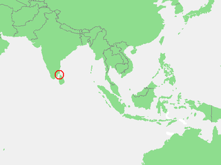
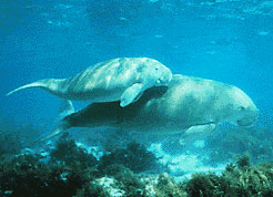
The Gulf of Mannar is a large shallow bay forming part of the Laccadive Sea in the Indian Ocean with an average depth of 5.8 m (19 ft). It lies between the southeastern tip of India and the west coast of Sri Lanka, in the Coromandel Coast region. The chain of low islands and reefs known as Ram Sethu, which includes Mannar Island, separates the Gulf of Mannar from Palk Bay, which lies to the north between India and Sri Lanka. The estuaries of Thamirabarani River and Vaippar River of South India and the Malvathu Oya of Sri Lanka drain into the Gulf. The dugong is found here.

Bazaruto is a sandy island located approximately 80 kilometres (50 mi) southeast of the mouth of the Save River, Mozambique. It is the largest island in the Bazaruto Archipelago and in the Bazaruto National Park.
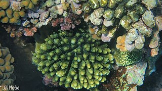
The Gulf of Mannar Marine National Park is a protected area of India consisting of 21 small islands (islets) and adjacent coral reefs in the Gulf of Mannar in the Indian Ocean. It lies 1 to 10 km away from the east coast of Tamil Nadu, India for 160 km between Thoothukudi (Tuticorin) and Dhanushkodi. It is the core area of the Gulf of Mannar Biosphere Reserve which includes a 10 km buffer zone around the park, including the populated coastal area. The park has a high diversity of plants and animals in its marine, intertidal and near shore habitats. Public access inside the park is limited to glass-bottom boat rides. It was established as a National Park in 1986.
South Button Island National Park is a national park located in the Andaman and Nicobar Islands off the coast of India, the total area of this protected island is about 5 km2 (2 sq mi). Along with the neighbouring islands of North Button and Middle Button, both also national parks, it forms part of the Rani Jhansi Marine National Park off the coast of South Andaman Island. Fossil National Park of Madhya Pradesh is the smallest national park in India.

Marine National Park in the Gulf of Kutch is situated on the southern shore of the Gulf of Kutch in the Devbhumi Dwarka district of Gujarat state, India. In 1980, an area of 270 km2 from Okha to Jodiya was declared Marine Sanctuary. Later, in 1982, a core area of 110 km2 was declared Marine National Park under the provisions of the Wildlife (protection) Act, 1972 of India. There are 42 islands on the Jamnagar coast in the Marine National Park, most of them surrounded by reefs. The best-known island is Pirotan.

Raja Ampat, or the Four Kings, is an archipelago located off the northwest tip of Bird's Head Peninsula on the island of New Guinea, in Indonesia's Southwest Papua province. It comprises over 1,500 small islands, cays, and shoals surrounding the four main islands of Misool, Salawati, Batanta, and Waigeo, and the smaller island of Kofiau.

Inhassoro District is a district of Inhambane Province in south-east Mozambique. The district is located at the northeast of the province, and borders with Govuro District in the north, Vilanculos District in the southeast, Massinga District in the south, Funhalouro District in the southwest, and with Mabote District in the west. In the east, the district is bounded by the Indian Ocean. The area of the district is 4,480 square kilometres (1,730 sq mi). It has a population of 48,537 as of 2007.

Benguerra Island in Mozambique is the second largest island in the Bazaruto Archipelago, which broke away from the mainland thousands of years ago. The island is approximately 55 square kilometers, and lies 14km offshore. Portuguese explorers also gave the island the name Santa Antonio. It is famous for its unspoiled white beaches, dive sites, luxury resorts, horseback riding and fishing.

The East African mangroves are a mangrove ecoregion consisting of swamps along the Indian Ocean coast of East Africa in Mozambique, Tanzania, Kenya and southern Somalia.
Santa Carolina is an island between the Mozambican mainland and Bazaruto Island in Mozambique. The closest town is called Inhassoro. It is just 2 by 0.3 miles in size. Santa Carolina is a true rock island with deep channels. Santa Carolina has three beaches with coral reefs close to the shore. The island, also known as Paradise Island is regarded as the ‘gem’ of the islands forming the Bazaruto Archipelago which is a proclaimed marine national park.
The Primeiras and Segundas Archipelago is a chain of 10 sparsely inhabited barrier islands and two coral reef complexes situated in the Indian Ocean off the coast of Mozambique and near the coastal city of Angoche. The islands lie in two groups along the western side of the Mozambique Channel.

The Bazaruto Archipelago National Park (BANP) is a protected area in the Inhambane Province of Mozambique on the Bazaruto Archipelago. The park was proclaimed on 25 May 1971. It is off the coast of the Vilanculos and Inhassoro districts, covering a large expanse of ocean and six islands.
The Chagos Marine Protected Area, located in the central Indian Ocean in the British Indian Ocean Territory of the United Kingdom, is one of the world's largest marine protected areas, and one of the largest protected areas of any type on Earth. It was established by the British government on 1 April 2010 as a massive, contiguous, no-take marine reserve, it encompasses 640,000 square kilometres (250,000 sq mi) of ocean waters, including roughly 70 small islands and seven atolls of the Chagos Archipelago.

The fauna of the United States Virgin Islands consists of 144 species of birds, 22 species of mammals, 302 species of fish and 7 species of amphibians. The wildlife of the U.S.V.I. includes numerous endemic species of tropical birds, fish, and land reptiles as well as sea mammals. The only endemic land mammals are six species of native bats: the greater bulldog bat, Antillean fruit-eating bat, red fruit bat, Brazilian free-tailed bat, velvety free-tailed bat and the Jamaican fruit bat. Some of the nonnative land mammals roaming the islands are the white-tailed deer, small Asian mongoose, goats, feral donkeys, rats, mice, sheep, hogs, dogs and cats.
Nosy Ve-Androka National Park is a Protected Marine Area located in the southwestern part of Madagascar, south of Tulear, and 40 km south of the tourist village of Anakao. It lies between latitudes 25 ° 29/25 ° 09 South and longitudes 44 ° 50/45 ° 06 East and covers an area of 92080 ha. It is composed of Core Areas totalling 28,820 ha and Buffer Zones totalling 63,260 ha. The park is made up of eight parcels in two clusters, with part found along the coast adjacent to Tsimanampetsotsa National Park. It includes sections of the rich coral reef system of South West Madagascar in the Mozambique Channel, recognized as the third largest reef system in the world. Diversity of habitats include fringing reefs, barrier reefs, coral reef beds, seagrass area, open sea, rocky coast and sandy beaches. The Nosy Ve-Androka National Park contains about 140 species of coral and 240 species of fish. There are also rare species such as Coelacanths, marine turtle species, dugongs, dolphins and whales and sandy beaches that are used by nesting sea turtles.
The East African coral coast is a marine ecoregion along the eastern coast of Africa. It extends along the coasts of Kenya, Tanzania, and northern Mozambique, from Lamu in Kenya to Angoche in Mozambique. It adjoins the Northern Monsoon Current Coast ecoregion to the north, and the Bight of Sofala/Swamp Coast ecoregion to the south.

Delagoa is a marine ecoregion along the eastern coast of Africa. It extends along the coast of Mozambique and South Africa from the Bazaruto Archipelago to Lake St. Lucia in South Africa in South Africa's Kwazulu-Natal province. It adjoins the Bight of Sofala/Swamp Coast ecoregion to the north, and the Natal ecoregion to the south. It has Africa's southernmost tropical coral reefs and mangrove forests. It is the southernmost Indo-Pacific ecoregion, marking the transition from the tropical Indo-Pacific to Temperate Southern Africa.


