Vilankulo

Last updated
Vilankulo
Vilanculos
Vilanculos from the air3.jpg
Market in Vilankulo
Mozambique adm location map.svg
Red pog.svg
Vilankulo
Coordinates: 22°0′S35°19′E / 22.000°S 35.317°E / -22.000; 35.317
Country Flag of Mozambique.svg  Mozambique
Provinces Inhambane Province
District Vilanculos District
Government
  TypeDemocratic
Population
 (2010 (estimate))
  Total24,433

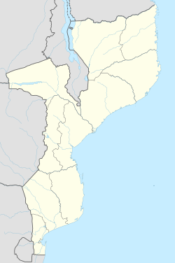
Vilankulo (or Vilanculos) is a coastal town in Mozambique, lying in the Vilanculos District of Inhambane Province. Vilankulo is named after local tribal chief Gamela Vilankulo Mukoke, and some of the "bairros" (suburbs) are named after his sons. Known as Vilanculos during colonial times, the name was changed to Vilankulo at independence. Today the district is called Vilanculos and the town Vilankulo.

Contents

Vilankulo has been growing extensively over the last decade, and has been the recipient of considerable inward investment into its tourism infrastructure. The town of Vilankulo is the gateway to the archipelago. Dhows and helicopters travel between the town and the Bazaruto Archipelago. The town itself is only about 5 km long. The airport is based on the outside of the town with flights arriving and departing on a daily basis.

It is home to a new international airport, which serves daily flights to several regional destinations, including Johannesburg and Maputo.
Sports

The local football club is called Vilankulo F.C. (VFC). [1] This is the first official club from Vilankulo that is recognized by the Mozambican Football Federation. In November 2009 Vilankulo FC was promoted to the Moçambola.

Vilankulo is the gateway to the Bazaruto Archipelago, ocean safaris and Padi dive and boat charter centre.

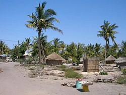
Typical homes and streets in Vilankulo Typical Vilankulo homes.JPG
Typical homes and streets in Vilankulo

Demographics

YearPopulation [2]
2010 estimate24,433

Climate

Climate data for Vilanculos (1961–1990)
MonthJanFebMarAprMayJunJulAugSepOctNovDecYear
Mean daily maximum °C (°F)30.8
(87.4)
30.9
(87.6)
30.7
(87.3)
29.3
(84.7)
27.4
(81.3)
25.7
(78.3)
25.2
(77.4)
25.8
(78.4)
27.0
(80.6)
28.0
(82.4)
29.1
(84.4)
30.1
(86.2)
28.3
(83.0)
Mean daily minimum °C (°F)23.5
(74.3)
23.1
(73.6)
22.3
(72.1)
20.0
(68.0)
16.9
(62.4)
14.6
(58.3)
14.2
(57.6)
15.5
(59.9)
18.2
(64.8)
20.3
(68.5)
22.0
(71.6)
23.1
(73.6)
19.5
(67.1)
Average rainfall mm (inches)152.2
(5.99)
160.4
(6.31)
79.7
(3.14)
41.0
(1.61)
36.3
(1.43)
23.7
(0.93)
17.5
(0.69)
23.4
(0.92)
9.1
(0.36)
40.1
(1.58)
58.5
(2.30)
138.0
(5.43)
779.9
(30.69)
Average rainy days910966664356979
Source: World Meteorological Organization [3]

Related Research Articles

<span class="mw-page-title-main">Inhambane Province</span> Province of Mozambique

Inhambane is a province of Mozambique located on the coast in the southern part of the country. It has an area of 68,615 km2 and a population of 1,488,676. The provincial capital is also called Inhambane.

<span class="mw-page-title-main">Nampula</span> City in Nampula Province, Mozambique

Nampula is the capital city of Nampula Province in Northern Mozambique. With a population of 743,125, it is the third-largest city in Mozambique after Maputo and Matola. The city is located in the interior of Nampula Province, approximately 200 kilometers from the coast and is surrounded by plains and rocky outcrops. The city is a major regional centre for the entire Northern region of Mozambique, as well as parts of Central Mozambique and border areas of Malawi and Tanzania.

<span class="mw-page-title-main">Mutare</span> Largest and Admistration City of Manicaland Province, Zimbabwe

Mutare, formerly known as Umtali until 1982, is the capital and largest city in the province of Manicaland. It is the third most populated in Zimbabwe. Having surpassed Gweru in the 2012 census, with an urban population of 224,802 and approximately 260,567 in the surrounding districts, Mutare adds to the wider metropolitan area a total population of over 500,000 people. Mutare is also the capital of Manicaland Province and the largest city in eastern Zimbabwe.

Bukoba is a city with a population of 144,938, situated in the northwest of Tanzania on the south-western shores of Lake Victoria. It is the capital of the Kagera region, and the administrative seat for Bukoba Urban District.

<span class="mw-page-title-main">Ballina, New South Wales</span> Town in New South Wales, Australia

Ballina is a town in the Northern Rivers region of New South Wales, Australia, and the seat of the Ballina Shire local government area. It lies 740 km (460 mi) north of Sydney and 185 km (115 mi) south of Brisbane. Ballina's urban population at the end of 2021 was 46,190.

<span class="mw-page-title-main">Örnsköldsvik</span> Place in Ångermanland, Sweden

Örnsköldsvik, often shortened to just Ö-vik, is a locality and the seat of Örnsköldsvik Municipality in Västernorrland County, Sweden, with 32,953 inhabitants in 2017.

<span class="mw-page-title-main">Bazaruto Archipelago</span>

The Bazaruto Archipelago is a group of six islands in Mozambique, near the mainland city of Vilankulo. It comprises the islands of Bazaruto, Benguerra, Magaruque, Santa Carolina and Bangué.

<span class="mw-page-title-main">Bazaruto Island</span>

Bazaruto is a barrier island in the Bazaruto Archipelago of southern Mozambique. The largest island of the archipelago, Bazaruto sits near the eastern rim of the African continental shelf, sheltering the mainland coast on the other side of Bazaruto Bay. Formed during the Pleistocene, Bazaruto's sand dunes along its eastern shore are among the tallest in the world, reaching heights up to 90 m (300 ft). Besides the dune system, the island is dotted with grasslands, salt marshes, mangrove swamps, and patches of freshwater wetland. It harbors a variety of wildlife, including blue monkeys, harnessed bushbuck, and red forest duiker. The waters around the island are a vital refuge for dugongs and sea turtles.

<span class="mw-page-title-main">Inhambane</span> City in Inhambane Province, Mozambique

Inhambane, also known as Terra de Boa Gente, is a city located in southern Mozambique, lying on Inhambane Bay, 470 km northeast of Maputo. It is the capital of the Inhambane Province and, according to the 2017 census, has a population of 79,724, growing from 54,157 in the 1997 census.

Articles related to Mozambique include:

Pelican Air Services was a trading name of Federal Air, an airline based in Johannesburg, South Africa. It now trades under the name Federal Air, and no longer uses the Pelican Air branding.

<span class="mw-page-title-main">Inhassoro District</span> District in Inhambane, Mozambique

Inhassoro District is a district of Inhambane Province in south-east Mozambique. The district is located at the northeast of the province, and borders with Govuro District in the north, Vilanculos District in the southeast, Massinga District in the south, Funhalouro District in the southwest, and with Mabote District in the west. In the east, the district is bounded by the Indian Ocean. The area of the district is 4,480 square kilometres (1,730 sq mi). It has a population of 48,537 as of 2007.

<span class="mw-page-title-main">Vilanculos District</span> District in Inhambane, Mozambique

Vilankulo District or Vilanculos District is a district of Inhambane Province in south-east Mozambique. Its principal town is Vilankulo. The district is located at the east of the province, and borders with Inhassoro District in the north and Massinga District in the south and in the west. In the east, the district is bounded by the Indian Ocean. The area of the district is 5,867 square kilometres (2,265 sq mi). It has a population of 135,710 as of 2007.

<span class="mw-page-title-main">Tourism in Mozambique</span>

The tourism assets of Mozambique include the country's natural environment, wildlife, and cultural heritage, which provide opportunities for beach, cultural, and eco-tourism.

<span class="mw-page-title-main">East African mangroves</span> Mangrove swamps on the Indian Ocean coast of East Africa

The East African mangroves are a mangrove ecoregion consisting of swamps along the Indian Ocean coast of East Africa in Mozambique, Tanzania, Kenya and southern Somalia.

<span class="mw-page-title-main">Santa Carolina</span>

Santa Carolina is an island between the Mozambican mainland and Bazaruto Island in Mozambique. The closest town is called Inhassoro. It is just 2 by 0.3 miles in size. Santa Carolina is a true rock island with deep channels. Santa Carolina has three beaches with coral reefs close to the shore. The island, also known as Paradise Island is regarded as the ‘gem’ of the islands forming the Bazaruto Archipelago which is a proclaimed marine national park.

<span class="mw-page-title-main">Bazaruto Archipelago National Park</span> Marine and terrestrial protected area in the Bazaruto Archipelago in Mozambique

The Bazaruto Archipelago National Park (BANP) is a protected area in the Inhambane Province of Mozambique on the Bazaruto Archipelago. The park was proclaimed on 25 May 1971. It is off the coast of the Vilanculos and Inhassoro districts, covering a large expanse of ocean and five islands.

<span class="mw-page-title-main">Cyclone Favio</span> South-West Indian cyclone in 2007

Intense Tropical Cyclone Favio was the first known tropical cyclone that passed south of Madagascar to strike Africa as an intense tropical cyclone. Early on 11 February 2007, a zone of disturbed weather formed east of Madagascar. Four days later, Favio was named as intensified to a moderate tropical storm while moving southwest. On 18 February, the storm was upgraded into a severe tropical storm. Then, it turned west in the general direction of Mozambique. Continuing to intensify, Favio was upgraded to a tropical cyclone early on 19 February. Subsequently, the storm began to undergo rapid deepening; the small storm reached intense tropical cyclone status the next day before peaking in intensity. However, the cyclone had weakened somewhat prior to making landfall on 22 February in the Inhambane Province in Mozambique. It rapidly weakened over land and dissipated the next day.

<span class="mw-page-title-main">Airlink Cargo</span> South African cargo airline

Airlink Cargo is a division of SA Airlink (Pty) Ltd and provides air freight transport services to over 35 destinations across Southern Africa from its base at O. R. Tambo International Airport. The division was formed in 2011 after one British Aerospace Jetstream 41 passenger aircraft belonging to parent company Airlink was converted for freight operations, followed the next year by a second aircraft. Freight is also carried on Airlink Cargo's behalf by Airlink and Swaziland Airlink across the region. Airlink Cargo is headquartered on the grounds of their hub near Johannesburg, South Africa.

<span class="mw-page-title-main">Delagoa</span> Marine ecoregion on the eastern coast of southern Africa

Delagoa is a marine ecoregion along the eastern coast of Africa. It extends along the coast of Mozambique and South Africa from the Bazaruto Archipelago to Lake St. Lucia in South Africa in South Africa's Kwazulu-Natal province. It adjoins the Bight of Sofala/Swamp Coast ecoregion to the north, and the Natal ecoregion to the south. It has Africa's southernmost tropical coral reefs and mangrove forests. It is the southernmost Indo-Pacific ecoregion, marking the transition from the tropical Indo-Pacific to Temperate Southern Africa.

References

  1. "Vilankulo Futebol Clube". Archived from the original on September 30, 2009. Retrieved June 8, 2009. football club official website
  2. "Mozambique: largest cities and towns and statistics of their population". World Gazetteer. Retrieved 2008-06-18.[ dead link ]
  3. "World Weather Information Service". World Meteorological Organization. Retrieved 18 August 2024.