
Chile, officially the Republic of Chile, is a country in western South America. It is the southernmost country in the world and the closest to Antarctica, stretching along a narrow strip of land between the Andes Mountains and the Pacific Ocean. With an area of 756,102 square kilometers (291,933 sq mi) and a population of 17.5 million as of 2017, Chile shares borders with Peru to the north, Bolivia to the northeast, Argentina to the east, and the Drake Passage to the south. The country also controls several Pacific islands, including Juan Fernández, Isla Salas y Gómez, Desventuradas, and Easter Island, and claims about 1,250,000 square kilometers (480,000 sq mi) of Antarctica as the Chilean Antarctic Territory. The capital and largest city of Chile is Santiago, and the national language is Spanish.

This is a list of the lists of islands in the world grouped by country, by continent, by body of water, and by other classifications. For rank-order lists, see the other lists of islands below.

South America is a continent entirely in the Western Hemisphere and mostly in the Southern Hemisphere, with a considerably smaller portion in the Northern Hemisphere. It can also be described as the southern subregion of the Americas.
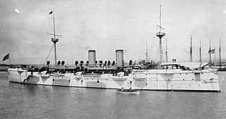
The Baltimore crisis was a diplomatic incident that took place between Chile and the United States, after the 1891 Chilean Civil War, as a result of the growing American influence in the Pacific Coast region of Latin America in the 1890s. It marked a dramatic shift in United States–Chile relations. It was triggered by the stabbing of two United States Navy sailors from USS Baltimore in front of the "True Blue Saloon" in Valparaíso on October 16, 1891. The United States government demanded an apology. Chile ended the episode when it apologized and paid a $75,000 indemnity.

The Southern Hemisphere is the half (hemisphere) of Earth that is south of the Equator. It contains all or parts of five continents and four oceans, as well as New Zealand and most of the Pacific Islands in Oceania. Its surface is 80.9% water, compared with 60.7% water in the Northern Hemisphere, and it contains 32.7% of Earth's land.

The Desventuradas Islands is a group of four small oceanic islands located 850 kilometres (530 mi) off the coast of Chile, northwest of Santiago in the Pacific Ocean. They are considered part of Insular Chile.

The Antarctic Plate is a tectonic plate containing the continent of Antarctica, the Kerguelen Plateau, and some remote islands in the Southern Ocean and other surrounding oceans. After breakup from Gondwana, the Antarctic plate began moving the continent of Antarctica south to its present isolated location, causing the continent to develop a much colder climate. The Antarctic Plate is bounded almost entirely by extensional mid-ocean ridge systems. The adjoining plates are the Nazca Plate, the South American Plate, the African Plate, the Somali Plate, the Indo-Australian Plate, the Pacific Plate, and, across a transform boundary, the Scotia Plate.

The Asia–Pacific (APAC) is the region of the world adjoining the western Pacific Ocean. The region's precise boundaries vary depending on context, but countries and territories in Australasia, East Asia, and Southeast Asia are often included. In a wider context, Central Asia, North Asia, the Pacific Islands, South Asia, West Asia, and even Pacific-adjoining countries in the Americas can be included. For example, the Asia-Pacific Economic Cooperation (APEC) includes five countries in the New World. The term has become popular since the late 1980s in commerce, finance, and politics. Despite the heterogeneity of the regions' economies, most individual nations within the zone are emerging markets experiencing rapid growth. Sometimes, the notion of "Asia–Pacific excluding Japan" (APEJ) is considered useful.

Mataveri International Airport or Isla de Pascua Airport is at Hanga Roa on Rapa Nui /. The most remote airport in the world, it is 2,336 miles (3,759 km) from Santiago, Chile (SCL) which has scheduled flights to it on the Chilean carrier LATAM Chile. The runway starts just inland from the island's southeast coast at Mataveri, and nearly reaches the west coast, almost separating the mountain of Rano Kau from the rest of the island. The airport is the main point of entry for visitors to Easter Island. It has a transit lounge that was formerly used by passengers continuing to or returning from Papeete, Tahiti, which was serviced by LATAM until June 2020.

The Chonos Archipelago is a series of low, mountainous, elongated islands with deep bays, traces of a submerged Chilean Coast Range. Most of the islands are forested with little or no human settlement. The deep Moraleda Channel separates the islands of the Chonos Archipelago from the mainland of Chile and from Magdalena Island.

The relationship between Chile and the United States, which dates back to the 19th century, has improved significantly since 1988 and is better than at any other time in history. In the late 1980s and early 1990s, the US government applauded the rebirth of democratic practices in Chile, despite having supported the 1973 coup d'état and subsequent military regime.
The following outline is provided as an overview of and topical guide to Chile:
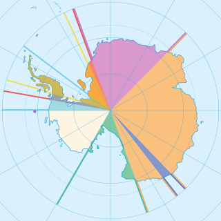
Seven sovereign states – Argentina, Australia, Chile, France, New Zealand, Norway, and the United Kingdom – have made eight territorial claims in Antarctica. These countries have tended to place their Antarctic scientific observation and study facilities within their respective claimed territories; however, a number of such facilities are located outside of the area claimed by their respective countries of operation, and countries without claims such as China, India, Italy, Japan, Pakistan, Russia, South Africa (SANAE), Poland, and the United States have constructed research facilities within the areas claimed by other countries. There are overlaps among the territories claimed by Argentina, Chile, and the United Kingdom.
Irish Chileans are the inhabitants of Chile who either came from some part of the island of Ireland or are descendants of immigrants from there. Generally coming in the 18th century and early 19th century, the generally Catholic Irish were seeking refuge from the oppression of the Protestant-run government of the Kingdom of Great Britain. Spain, being a Catholic power, enticed many Irish to move to Latin America. Immigration diminished later in the 19th century as Catholic Emancipation made emigration to a Catholic nation less of a vital consideration and as the United States and Canada established themselves as more viable lands for settlement.
The South American Board of New Football Federations, also known by its acronym COSANFF is the administrative and controlling body for non-FIFA football federations in South America. It was also initially affiliated with the now defunct N.F.-Board.

Chilean expansionism refers to the foreign policy of Chile to expand its territorial control over key strategic locations and economic resources as a means to ensure its national security and assert its power in South America. Chile's significant territorial acquisitions, which occurred mostly throughout the 19th century, paved the way for its emergence as a thalassocracy and one of the three most powerful and wealthiest states in South America during the 20th century. It also formed Chile's geopolitical and national identity as a tricontinental state and one of the countries with the longest coastlines in the world.
The 2019 FIBA Basketball World Cup qualification for the FIBA Americas region, began in November 2017 and concluded in February 2019. The process determined the seven teams that would participate at the 2019 FIBA Basketball World Cup.
