The Aysén del General Carlos Ibáñez del Campo Region, often shortened to Aysén Region or Aisén, is one of Chile's 16 first order administrative divisions. Although the third largest in area, the region is Chile's most sparsely populated region with a population of 102,317 as of 2017. The capital of the region is Coihaique, the region's former namesake.
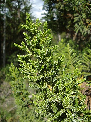
Pilgerodendron is a genus of conifer belonging to the cypress family Cupressaceae. It has only one species, Pilgerodendron uviferum, which is endemic to the Valdivian temperate rain forests and Magellanic subpolar forests of southern Chile and southwestern Argentina. It grows from 40 to 54°20' S in Tierra del Fuego, where it is the southernmost conifer in the world. It is a member of subfamily Callitroideae, a group of distinct Southern Hemisphere genera associated with the Antarctic flora.
The Guayaneco Archipelago is an archipelago in southern Chile. It consists of 2 main islands, Wager Island, es:Isla Byron, and many smaller islands.
The Central Valley, Intermediate Depression, or Longitudinal Valley is the depression between the Chilean Coastal Range and the Andes Mountains. The Chilean Central Valley extends from the border with Peru to Puerto Montt in southern Chile, with a notable interruption at Norte Chico. South of Puerto Montt the valley has a continuation as a series of marine basins up to the isthmus of Ofqui. Some of Chile's most populous cities lie within the valley including Santiago, Temuco, Rancagua, Talca and Chillán.

Gulf of Corcovado is a large body of water separating the Chiloé Island from the mainland of Chile. Geologically, it is a forearc basin that has been carved out by Quaternary glaciers. Most of the islands of Chiloé Archipelago are located in the gulf. The area is next to the Chiloé National Park.

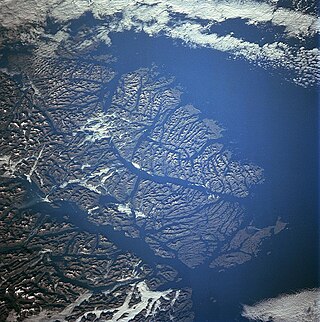
Aysén Fjord is an ~70 km long fjord stretching east from a skerry-guarded (skjærgård) region called Moraleda Channel, which is a body of water separating the Chonos Archipelago from the mainland of Chile. It is located at 45.26°S 73.00°W and is connected indirectly to the open coast of the Pacific Ocean via the Darwin Channel. The Aysén River discharges at the head of Aysén Fjord.

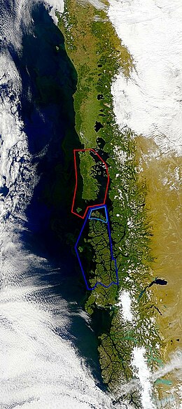
The Taitao Peninsula is a westward projection of the mainland of Chile, with which it is connected by the narrow Isthmus of Ofqui, over which the natives and early missionaries were accustomed to carry their boats between the Moraleda Channel and Gulf of Penas. It is situated in the Aysén del General Carlos Ibáñez del Campo Region and a part of this peninsula is located inside the boundaries of Laguna San Rafael National Park. The Presidente Ríos Lake, with a surface area of 352 square kilometres (136 sq mi), lies in the middle of the peninsula. A southward incurving projection of the outer shoreline of this peninsula is known as Tres Montes peninsula, the most southern point of which is a cape of the same name.
The Gulf of Penas is a body of water located south of the Taitao Peninsula, Chile.

Melinka is a Chilean town in Aysén Province, Aysén Region. It is located on Ascención Island and is the administrative center of the commune of Guaitecas since 1979.

The Chiloé Archipelago is a group of islands lying off the coast of Chile, in the Los Lagos Region. It is separated from mainland Chile by the Chacao Channel in the north, the Sea of Chiloé in the east and the Gulf of Corcovado in the southeast. All islands except the Desertores Islands form Chiloé Province. The main island is Chiloé Island. Of roughly rectangular shape, the southwestern half of this island is a wilderness of contiguous forests, wetlands and, in some places, mountains. The landscape of the northeastern sectors of Chiloé Island and the islands to the east is dominated by rolling hills, with a mosaic of pastures, forests and cultivated fields.
Guaitecas Archipelago is a sparsely populated archipelago in the Aisén region of Chile. The archipelago is made up of eight main islands and numerous smaller ones. The eight largest islands are from northwest to southeast: Gran Guaiteca, Ascención, Betecoy, Clotilde, Leucayec, Elvira, Sánchez and Mulchey. The islands have subdued topography compared to the Andes, with Gran Guaiteca containing the archipelago's high point at 369 m (1,211 ft).

The Chono, or Guaiteco were a nomadic indigenous people or group of peoples of the archipelagos of Chiloé, Guaitecas and Chonos.

Abtao Island is part of the Chiloé Archipelago, Chile.
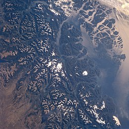
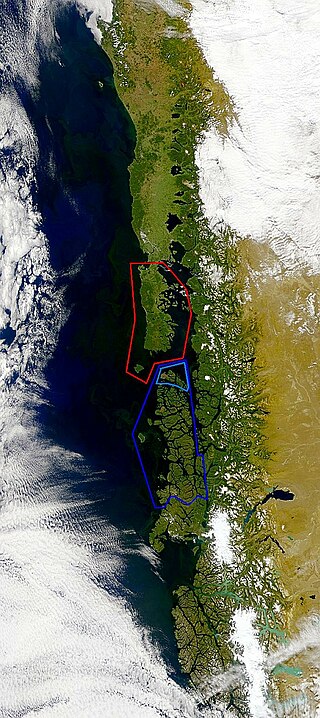
The southern coast of Chile presents a large number of fjords and fjord-like channels from the latitudes of Cape Horn to Reloncaví Estuary. Some fjords and channels are important navigable channels providing access to ports like Punta Arenas, Puerto Chacabuco and Puerto Natales.
Felipe Arnold Westhoff Rodhius was a 19th-century entrepreneur known for his role in the logging of Pilgerodendron uviferum and the founding of Melinka in Guaitecas Archipelago in 1860. Westhoff was an ethnic German who migrated to South America from Lithuania, which was then part of the Russian Empire.

Enrique Simpson Baeza was a Chilean Navy officer and explorer. Simpson mapped the archipelagoes and coast of Aysén Region onboard of the corvette Chacabuco in the 1870s. Among his feats is the re-discovery of San Rafael Lake and the insight that Aisén Fjord provides the best access to the interior of Patagonia from the Pacific.
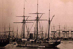
The Chilean corvette Chacabuco was a late 19th-century ship of the Chilean Navy. Commanded by Enrique Simpson in the early 1870s, the ship participated in the exploration of the fjords and archipelagoes of Aysén Region in northern Patagonia. These travels led to the re-discovery of San Rafael Lake and the establishment of Aysén Fjord as the principal access to the inland of Aysén Region. In 1876 Chacabuco transported governor of Magallanes Diego Dublé Almeyda to the Falkland Islands bringing back sheep, thus initiating the Patagonian sheep farming boom of the late 19th century. From 1879 onwards the corvette fought in the War of the Pacific.

Astelia pumila is a species of flowering plant in the recently named family Asteliaceae. It is an evergreen silver-green perennial from western Patagonia in southern Chile and nearby areas of Argentina. It grows in forests as well as wetlands. The plant is, together with Donatia fascicularis, dominant in the cushion bogs that exists in areas exposed to the Pacific coast. As such, it does not usually occur together with Sphagnum which tends to grow slightly more inland. Localities where the plant is found include, from north to south; Queulat National Park, Chonos Archipelago, Taitao Peninsula, San Rafael Lake, the vicinities of Caleta Tortel and Tierra del Fuego National Park.
The Antonio de Vea expedition of 1675–1676 was a Spanish naval expedition to the fjords and channels of Patagonia aimed to find whether rival colonial powers—specifically, the English—were active in the region. While this was not the first Spanish expedition to the region, it was the largest up to then, involving 256 men, one ocean-going ship, two long boats and nine dalcas. The expedition dispelled suspicion about English bases in Patagonia. Spanish authorities' knowledge of western Patagonia was greatly improved by the expedition, yet Spanish interest in the area waned thereafter until the 1740s.

Wager Island is an uninhabited island in Guayaneco Archipelago, a remote part of western Patagonia. Located 1,600 kilometres south of Santiago, the island is part of Capitán Prat Province of the Aysén Region, Chile. The island was the location of the Wager Mutiny, which took place in October 1741 after the wreck of the British warship HMS Wager.