Narrandera, until around 1949 also spelled "Narandera", is a town located in the Riverina region of south-western New South Wales, Australia. The town lies on the junction of the Newell and Sturt highways, adjacent to the Murrumbidgee River, and it is considered the gateway to the Murrumbidgee Irrigation Area. At the 2016 census, Narrandera had a population of 3746 people.

Yanco is a village with a population of 432 in Leeton Shire in south western New South Wales, Australia. Yanco is a Wiradjuri aboriginal language word meaning the sound of running water. Yanco is located 3 kilometres (1.9 mi) from Leeton along Irrigation Way. Yanco is home to the Powerhouse Museum, McCaughey Park, Murrumbidgee Rural Studies Centre and Yanco Agricultural High School. Murrumbidgee Irrigation builds the Roach’s Surge Reservoir near Yanco, holding up to 5 million tonnes of water.
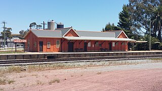
Leeton railway station is a heritage-listed former goods yard and railway station and now bus station and railway station located on the Yanco–Griffith line at Dunn Avenue in Leeton in the Leeton Shire local government area of New South Wales, Australia. It is also known as Leeton Railway Station and yard group. The property was added to the New South Wales State Heritage Register on 2 April 1999.
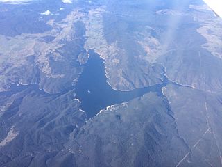
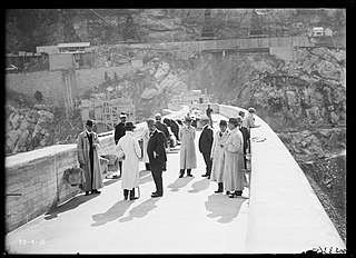
Burrinjuck Dam is a gated, concrete-walled hydro-electric gravity dam at Burrinjuck, in the South West Slopes region of New South Wales, Australia. It has three spillways across the Murrumbidgee River and forms an impounded reservoir called Lake Burrinjuck. In addition to electricity generation, Burrinjuck Dam is used for purposes including flood mitigation, irrigation, water supply and conservation. Also known as Barren Jack Dam and Barrenjack, it was added to the New South Wales State Heritage Register on 2 April 1999.

The Upper Nepean Scheme is a series of dams and weirs in the catchments of the Cataract, Cordeaux, Avon and Nepean rivers of New South Wales, Australia. The scheme includes four dams and two weirs, and a gravity-fed canal system that feeds into a large storage reservoir to provide water to the Macarthur and Illawarra regions, the Wollondilly Shire, and metropolitan Sydney. The four dams and associated infrastructure are individually listed on the New South Wales State Heritage Register.

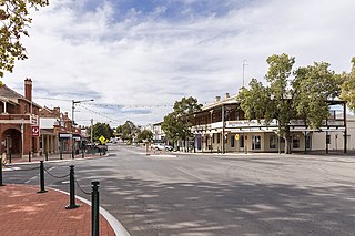
Grong Grong is a small town that is located in the Riverina region of New South Wales, Australia. The town is situated on the Newell Highway, 23 kilometres (14 mi) east of Narrandera in the Shire of Narrandera.

The Prospect Reservoir is a heritage-listed 50,200-megalitre potable water supply and storage reservoir created by the Prospect Dam, across the Prospect Creek located in the Western Sydney suburb of Prospect, in New South Wales, Australia. The eastern bounds of the reservoir are a recreational area and the western periphery are within the bounds of Western Sydney Parklands. It was added to the New South Wales State Heritage Register on 18 November 1999.
Burrinjuck is a village community in the far eastern part of the Riverina, in the South West slopes of New South Wales. By road it is about 15 kilometres (9.3 mi) southwest of Woolgarlo and 28 kilometres (17 mi) south from Bookham. The name of the town is derived from an Aboriginal word meaning 'mountain with a rugged top'. At the 2016 census, the Burrinjuck area had a population of 19.

Tantangara Dam is a major ungated concrete gravity dam with concrete chute spillway across the Murrumbidgee River in Tantangara, upstream of Adaminaby in the Snowy Mountains region of New South Wales, Australia. The dam is part of the Snowy Mountains Scheme, a vast hydroelectricity and irrigation complex constructed in south-east Australia between 1949 and 1974 and now run by Snowy Hydro. The purpose of the dam includes water management and conservation, with much of the impounded headwaters diverted to Lake Eucumbene. The impounded reservoir is called Tantangara Reservoir.

The Assiut Barrage is a dam on the Nile River in the city of Assiut in Upper Egypt. It was completed in 1903.

The Yanga National Park is a newly formed national park, located near the township of Balranald in south- western New South Wales. It covers an area of 66,734 hectares which includes 1,932 hectares of Yanga Nature Reserve, and has a frontage of 170 kilometres (110 mi) on the Murrumbidgee River. It is largely located in the Lower Murrumbidgee Floodplain, which is included on A Directory of Important Wetlands in Australia because of its importance as a breeding site for waterbirds when flooded.

The Menindee Lakes is a system of 9 large, but relatively shallow lakes, located in south-west New South Wales on the Darling (Barka) River, about 200 km upstream of the Darling River's junction with the River Murray. The Darling River is fed by nine major tributary river systems flowing from south-east Queensland and north and central NSW. The town of Menindee is close to the lakes and Sunset Strip township is on the northern shore of Lake Menindee. The nearest city is Broken Hill.

The Taemas Bridge is a two-lane road bridge that carries the Wee Jasper Road across the Murrumbidgee River, at the settlement of Taemas, near Wee Jasper in the Yass Valley Council local government area of New South Wales, Australia. The bridge crosses on the river just before it enters Lake Burrinjuck, which has been created by the Burrinjuck Dam. The bridge is a key part of the road between Yass and Wee Jasper, and from there, to Tumut. The bridge is located approximately 26 kilometres (16 mi) from Yass and 22 kilometres (14 mi) from Wee Jasper. The property is owned by Transport for NSW. Under the Heritage Act, 1977 (NSW) s 170, the bridge was added to the New South Wales State agency heritage register on 18 August 2005.

The Upper Canal System, also called the Southern Railway Aqueduct and the Cataract Tunnel, is a heritage-listed operational gravity-fed aqueduct that supplies some of the potable water for Sydney, in New South Wales, Australia. The aqueduct comprises 54 kilometres (34 mi) of open canals, tunnels, and closed pipelines that connect the Upper Nepean Scheme with the Prospect Reservoir. The aqueduct is managed by the Sydney Catchment Authority on behalf of WaterNSW, an agency of the Government of New South Wales. It was listed on the New South Wales State Heritage Register on 18 November 1999.
Greater Burrinjuck Dam Site is a heritage-listed dam surrounds at Burrinjuck, Yass Valley Shire, New South Wales, Australia. It is also known as Burrinjuck Dam Site and Barren Jack or Barrenjack. The property is owned by Department of Planning and Infrastructure. It was added to the New South Wales State Heritage Register on 2 April 1999.
Barren Jack Creek Water Supply Dam is a heritage-listed dam at Burrinjuck, in the Southern Tablelands region of New South Wales, Australia. It was built in 1908 by the New South Wales Department of Public Works. The property is owned by Department of Planning and Infrastructure. It was added to the New South Wales State Heritage Register on 2 April 1999.
Wooden Wicket, Berembed Weir is a heritage-listed wooden weir component at Berembed Weir, Murrumbidgee River, Matong, City of Wagga Wagga, New South Wales, Australia. It was made in 1910 at Fitzroy Dock in Sydney. It was added to the New South Wales State Heritage Register on 2 April 1999.

Yanco Weir is a heritage-listed weir at Yanco, Leeton Shire, New South Wales, Australia. It was built from 1928 to 1929 by WC & IC. It is also known as Yanco Weir and site. The property is owned by Department of Planning and Infrastructure, a department of the Government of New South Wales. It was added to the New South Wales State Heritage Register on 2 April 1999.

The Gogeldrie Weir is a heritage-listed former weir and now recreation area and weir at Murrumbidgee River near Narrandera, Leeton Shire, New South Wales, Australia. It was designed and built by WC & IC from 1958 to 1959. It was added to the New South Wales State Heritage Register on 2 April 1999.

The Leeton District Office artefacts is a heritage-listed collection of artefacts at a waterworks at Chelmsford Place, Leeton in the Leeton Shire local government area of New South Wales, Australia. It is also known as Leeton District Office - Artefacts in Reception Lobby Showcase 1. The property is owned by Department of Planning and Infrastructure, an agency of the Government of New South Wales. It was added to the New South Wales State Heritage Register on 2 April 1999.

