Wellington College is a boys secondary school in the Wellington, New Zealand suburb of Mount Victoria.

Levin is the largest town and seat of the Horowhenua District, in the Manawatū-Whanganui region of New Zealand's North Island. It is located east of Lake Horowhenua, around 95 km north of Wellington and 50 km southwest of Palmerston North.
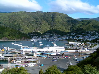
Picton is a town in the Marlborough Region of New Zealand's South Island. The town is located near the head of the Queen Charlotte Sound / Tōtaranui, 25 km (16 mi) north of Blenheim and 65 km (40 mi) west of Wellington. Waikawa lies just north-east of Picton.

Petone, a large suburb of Lower Hutt in the Wellington Region of New Zealand's North Island, stands at the southern end of the Hutt Valley, on the northern shore of Wellington Harbour. The Māori name Pito-one means "end of the sand beach".

Wellington City Council is a territorial authority in New Zealand, governing the country's capital city, and de facto second-largest city. It consists of the central historic town and certain additional areas within the Wellington metropolitan area, extending as far north as Linden and covering rural areas such as Mākara and Ohariu. The city adjoins Porirua in the north and Hutt City in the north-east. It is one of nine territorial authorities in the Wellington Region.

Westport is a town in the West Coast region of the South Island of New Zealand. Established in 1861, it is the oldest European settlement on the West Coast. Originally named Buller, it is on the right bank and at the mouth of the Buller River, close by the prominent headland of Cape Foulwind. It is connected via State Highway 6 with Greymouth, 100 kilometres (62 mi) to the south, and with Nelson 222 kilometres (138 mi) in the northeast, via the Buller Gorge. The population of the Westport urban area was 4,035 in the 2013 census, an increase of 138 from 2006. Including the surrounding area of Orowaiti, the 2013 population was 4,755. The Buller District had a population of 10,473 in 2013.

Berhampore is a suburb of Wellington, New Zealand. It lies towards the south of the city, four kilometres from the city centre, and two kilometres from the coast of Cook Strait. It is surrounded by the suburbs of Vogeltown, Newtown, Melrose, Island Bay, Kingston, and Mornington. The suburb was named after Berhampore in Bengal, one of the battlefields at the start of the Battle of Plassey of 1757. Also surrounding Berhampore is the Berhampore Golf Course as well as a very extensive green belt with many walkways and tracks connecting outlying areas. The suburb also boasts some of Wellington's best all weather sports fields, on Adelaide Road and the national hockey stadium. Alongside the golf course there is a skateboard/bmx park, right by a kids mountain bike track. Berhampore School opened in 1915.

Featherston is a town in the South Wairarapa District, in the Wellington Region of New Zealand's North Island. It is at the eastern foothills of Remutaka Range close to the northern shore of Lake Wairarapa, 63 km (39 mi) north-east of central Wellington and 37 km (23 mi) south-west of Masterton.

Berhampore is a city and a municipality in the state of West Bengal, India. As of the 2011 census, Berhampore Urban Agglomeration had a population of 305,609 and was the seventh largest city in West Bengal. Berhampore is the administrative headquarters of the Murshidabad district. It is located about 200 km (124 mi) from Kolkata, the state capital. It is one of the most important business, administrative, educational and political hub of Bengal as well as of India. Congress Lok Sabha leader Sri Adhir Ranjan Chowdhury is elected from this city. It is one of the most popular Urban agglomerations of West Bengal state. It was the first centre of East India Company in India. Not only British but also Dutch and French established their companies in this city as a result it grew as a production hub of India. It is famous for its famous sweets such as Chanabora, Manohara, Rasgulla and many more. The city is divided into five administrative regions: Gorabazar, Khagra, Indraprastha, Cossimbazar, Haridasmati. Berhampore was a part of Sepoy Mutiny of 1857 which took place at Berhampore Cantonment region. It was used by many foreign traders as their production hub. Before becoming a city many janpadas such as Saidabad; Farasdanga; Kalikapur had become famous. Cossimbazar had also become world famous for its muslin clothes. This city used to be the headquarters of Rajsahi administrative region till 1875.
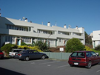
The Berhampore State Flats at 493–507 Adelaide Road, Berhampore, Wellington, New Zealand, are an example of mass housing designed in the international style. The flats were designed by F. Gordon Wilson, chief architect at the Department of Housing Construction.
Samuel Marsden Collegiate School is located in the Wellington suburb of Karori in New Zealand. It has a socio-economic decile of 10 and provides private year 1 to 13 education for girls, with a co-educational Preschool. Its exam results rank consistently in the top schools in New Zealand. Samuel Marsden Collegiate School students complete the New Zealand National Certificate of Educational Achievement (NCEA) but the school also offers Cambridge A-Level exams in certain subjects.

Lepperton is a small village in North Taranaki, New Zealand. It is approximately 6 km (3.7 mi) inland from Waitara township, 5 km (3.1 mi) west of the Waitara River, and 1 km (0.62 mi) east of State Highway 3A, which connects Inglewood to Waitara.
Cardinal McKeefrySchool is a Catholic primary school and intermediate school for girls and boys catering from Year 1 to Year 8. The school traces its origins to the Marist Brothers' first school opened in New Zealand in 1876. The current school was opened in 1970 by Cardinal Peter McKeefry and named after him.

Piopio College is a coeducational secondary school in Piopio, a town in the Waitomo District of New Zealand.
St Catherine's College, a Catholic secondary school for girls, operates in the Wellington suburb Kilbirnie in New Zealand. The Sisters of Mercy founded St Catherine's in 1919 initially as a primary school before becoming a secondary school in 1950.
Sacred Heart College, Napier is a state-integrated Catholic girls' secondary school located in Napier, New Zealand.
Sacred Heart Girls' College is a single-sex (girls) secondary and intermediate school in New Plymouth, New Zealand.

Marcellin College is a Catholic, integrated, co-educational college in Royal Oak, Auckland, New Zealand for students in Year 7 to Year 13. The college was founded by the Marist Brothers in 1958 as a school for boys only. The school follows the values of Marist education, which was formed by the name of the school and patron saint, St Marcellin Champagnat. The school is located on spacious and beautiful grounds which had been part of the Pah estate. It has an extensive woodland on its southern and western boundaries. Most of the former Pah estate contiguous with Marcellin College is now owned by the Auckland Council and is maintained as a park known as "Monte Cecilia Park." The Auckland Franciscan Friary and Retreat Centre is just across Monte Cecilia Park from the college. A Discalced Carmelite Monastery is directly opposite the college on Mt Albert Rd.
The suburb of Newtown lies in the southern part of Wellington in New Zealand. It lies east of Vogeltown, between Mount Cook and Berhampore. The main thoroughfares of Newtown are Riddiford St, leading from Mount Cook to Berhampore and Melrose, and Constable St, leading from Newtown to Kilbirnie.
Eric John Rich Was born 8 Feb 1894 in Vila Rica, Paraguay, South America to John Rich (1862-1939) and Esther Maria Barrett (1868-1948). Eric was an Anglican bishop in the third quarter of the 20th century.

