
U2 is a line of the Berlin U-Bahn. The U2 line starts at Pankow S-Bahn station, runs through the eastern city centre (Alexanderplatz) to Potsdamer Platz, the western city centre and finally to the Ruhleben terminal station.
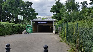
Berlin Jungfernheide is a railway station located at Charlottenburg-Nord, in the Charlottenburg-Wilmersdorf district of Berlin, served by the S-Bahn lines S41 and S42, the U-Bahn line U7 and Regional-Express trains of the Deutsche Bahn. Its name literally translates into "maidens' heathland"; it was named after the Jungfernheide, a former large forest in the proximity of this station.

The S26 is a service of the Berlin S-Bahn. It runs from Teltow in the district (Kreis) of Potsdam-Mittelmark via Südkreuz, through the Berlin Nord-Süd Tunnel with a stop at Friedrichstraße, and ends in Blankenburg in the borough of Pankow. On weekends the S26 runs from Teltow to Potsdamer Platz. The current service began operation in December 2017.

The Potsdamer Bahnhof is a former railway terminus in Berlin, Germany. It was the first railway station in Berlin, opening in 1838. It was located at Potsdamer Platz, about 1 km south of the Brandenburg Gate, and kick-started the transformation of Potsdamer Platz from an area of quiet villas near the south-east corner of the Tiergarten park into the bustling focal point that it eventually became. For more than a century it was the terminus for long-distance and suburban trains. Also located at this spot were underground stations on the Berlin U-Bahn and S-Bahn, and today's new underground Regionalbahnhof, known as Bahnhof Potsdamer Platz, while the short-lived M-Bahn crossed the site of the former terminus.

Berlin-Pankow is a station on the Berlin–Szczecin railway, situated in Berlin's Pankow district. It is served by the S-Bahn lines S2, S8 and S26 and is the northern terminus of the U-Bahn line U2.
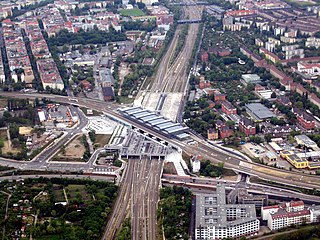
Berlin Südkreuz station is a railway station in the German capital Berlin. The station was originally opened in 1898 and is an interchange station. The Berlin Ringbahn line of the Berlin S-Bahn metro railway is situated on the upper level and connects to the east and west, whilst the Anhalter Bahn and Dresdner Bahn intercity railway routes reach the station on the lower, north-south level. The station was extensively rebuilt between the late 1990s and 2006, and was renamed Berlin Südkreuz on 28 May 2006.

The Ringbahn is a 37.5 km (23.3 mi) long circle route around Berlin's inner city area, on the Berlin S-Bahn network. Its course is made up of a pair of tracks used by S-Bahn trains and another parallel pair of tracks used by various regional, long distance and freight trains. The S-Bahn lines S41 and S42 provide a closed-loop continuous service without termini. Lines S45, S46 and S47 use a section of the southern and western ring, while lines S8 and S85 use sections of the eastern ring. The combined number of passengers is about 400,000 passengers a day. Due to its distinctive shape, the line is often referred to as the Hundekopf.

Berlin Potsdamer Platz is a railway station in Berlin. It is completely underground and situated under Potsdamer Platz in central Berlin. Regional and S-Bahn services call at the station, and it is also served by U-Bahn line U2.

Berlin Gesundbrunnen station is a railway station in Berlin, Germany. It is situated in the Gesundbrunnen district, part of the central Mitte borough, as an interconnection point between the northern Ringbahn and Nord-Süd Tunnel lines of the Berlin S-Bahn, as well as a regional and long distance station of the Deutsche Bahn network. The station is operated by the DB Station&Service subsidiary of Deutsche Bahn AG and is classified as a Category 1 station, one of 21 in Germany and four in Berlin, the others being Berlin Hauptbahnhof, Berlin Südkreuz and Berlin Ostbahnhof.
Birkenwerder is a railway station in the town of Birkenwerder, Brandenburg, Germany. The station lies of the Berlin Northern Railway and the train services are operated by Deutsche Bahn including Berlin S-Bahn services.
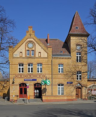
Berlin Wollankstraße is a railway station in the Pankow district of Berlin, Germany. It is served by the Berlin S-Bahn and several local buses.

Berlin Humboldthain station is a railway station in the city of Berlin, Germany. It is served by the Berlin S-Bahn lines S1,S2,S25 and S26. It is also served by local bus route 247.

Mitte is a central section of Berlin, Germany, in the eponymous borough of Mitte. Until 2001, it was itself an autonomous district.

Berlin-Lichterfelde Ost station is on the Anhalt Suburban Line in Lichterfelde in the Berlin borough of Steglitz-Zehlendorf. It is served by S-Bahn line S25, S-Bahn line S26, and Regional-Express lines 3, 4 and 5.

Hennigsdorf is a railway station in the Oberhavel district of Brandenburg, located in the town of Hennigsdorf. It is the northern terminus of the S-Bahn line S25 as well as a station for regional passenger trains and freight services.

The North–South S-Bahn Tunnel is the central section of the North–South transversal Berlin S-Bahn connection crossing the city centre. It is not to be confused with the Tunnel Nord-Süd-Fernbahn, the central tunnel part of the North–South main line used by intercity and regional trains. The S-Bahn North–South line encompasses the route from Bornholmer Straße and Gesundbrunnen via Friedrichstraße and Anhalter Bahnhof to Papestraße and Schöneberg.

BER Airport station, until December 2023 Flughafen BER – Terminal 1-2 station, is a railway station located under the main terminal of Berlin Brandenburg Airport, Germany serving its Terminals 1 and 2. Most train services are operated by Deutsche Bahn, which provides long-distance and regional connections while S-Bahn Berlin offers suburban lines.

S15 is a planned second north-south route for the Berlin S-Bahn, which will connect Berlin Hauptbahnhof to the Berlin Ringbahn to both north and south. The first section is under construction and is expected to go into operation in 2024.

The Berlin S-Bahn began on 8 August 1924 with the first section from Stettiner Vorortbahnhof to Bernau using steam locomotives. On 13 August 1961 it was broken up when the Berlin Wall was built, resulting in two sections: the eastern part and the western part. The western part experienced a massive strike which resulted in closure of several stations, after declining use. Attempts were made to reopen at various times but in the end, only three lines were finally opened after the strike. Since 9 November 1989, when the Berlin Wall was opened, the Berlin S-Bahn began to expand rapidly with their budgetary costs.

The Berlin U-Bahn originated in 1880 with Werner Siemens' idea to build an urban railway in Berlin. During the nine years after the German Empire was founded, the city's population grew by over one-third and traffic problems increased. In 1896, Siemens & Halske began to construct the first stretch of overhead railway. On 1 April 1897, the company began construction of an electric underground railway. The Berliner Verkehrs Aktiengesellschaft (BVG) was formed in 1928, and took over further construction and operation of the network. In 1938, the company was renamed Berlin Transport Company; the original acronym, however, remained. Since 1994, the BVG has been a public company.


