Berlin-Staaken station

Last updated
Berlin-Staaken
Through station
Bf-b-staaken.jpg
General information
Location Staaken, Spandau, Berlin
Germany
Coordinates 52°32′16″N13°08′29″E / 52.53778°N 13.14139°E / 52.53778; 13.14139
Line(s)
Platforms2
Other information
Station code564
DS100 code BSTA [1]
Category 6 [2]
Fare zone VBB: Berlin B/5656 [3]
Website www.bahnhof.de
History
Opened15 August 1900;123 years ago (1900-08-15)
Closed S-Bahn-Logo.svg 18 September 1980 (strike), officially 28 September 1980;43 years ago (1980-09-28)
Rebuilt1951: new Deutsche Reichsbahn DDR.svg platform in West Staaken, opposite to S-Bahn-Logo.svg station in East Staaken
1976: new Deutsche Reichsbahn DDR.svg station 700 further west
1998: new main line station 700 further east
Electrified S-Bahn-Logo.svg 3 August 1951;72 years ago (1951-08-03), 750 V DC system (3rd rail)
main line: 13 December 1998;25 years ago (1998-12-13), 15 kV AC system (overhead)
Previous names1910-1937 Staaken
1937-1980 S-Bahn-Logo.svg Berlin-Staaken
1962-1990 Deutsche Reichsbahn DDR.svg Staaken
Key dates
13 August 1961 - 4 March 1962 S-Bahn-Logo.svg operation interrupted
1995 - 1998operation interrupted
Services
Preceding station ODEG-Logo Neu.svg Ostdeutsche Eisenbahn Following station
Dallgow-Döberitz
towards Rathenow
RE 4 Berlin-Spandau
Preceding station Deutsche Bahn AG-Logo.svg DB Regio Nordost Following station
Dallgow-Döberitz
towards Potsdam Hbf
RB 21 Berlin-Spandau
Berlin-Staaken station
Location
Berlin location map.svg
Red pog.svg
Berlin-Staaken
Location within Berlin

Berlin-Staaken is a railway station located in Staaken, a locality in the Spandau district of Berlin. It is one of only two Deutsche Bahn stations in Berlin not served by the S-Bahn; Albrechtshof station is the other.

Contents

Overview

The station is situated on the "Lehrter Bahn" Berlin-Wolfsburg-Hannover, between the stations of Berlin Spandau and Dallgow-Döberitz. The station has two platforms.

The first station in Staaken was opened in 1900.[ citation needed ] That should change drastically after the Second World War. Staaken was divided by the Allies. The continuous train traffic was interrupted. On West Berlin side 1951 the rapid-transit railway of Spandau west was extended by a station to Staaken. Already in the 1930s an extension of the rapid-transit railway to the Brandenburg Wustermark had been aimed at. The S-Bahn station Berlin-Staaken was in West Berlin. On the other side of the Nennhauser dam was the station Staaken Kr. Nauen (at the former freight yard Staaken) in the GDR area, from where suburban trains in the direction of Wustermark and Nauen reversed. To change trains between S-Bahn and suburban trains, passengers had to change stations and pass a checkpoint. With the building of the Wall, another Staaken station was added far before the border: Staaken (GDR). He served the control of freight trains between West Berlin and the Federal territory or the GDR.

Transit train from Hamburg passes through the border facilities at Staaken station, 1986 19861025a Staaken.jpg
Transit train from Hamburg passes through the border facilities at Staaken station, 1986

When Staaken was also to be passed by transit trains of travel traffic between Berlin and Hamburg in 1976, a new control station Staaken (GDR) was built further west. Before, since 1961, the Hamburg long-distance trains had to take the detour via the Berlin outer ring and Griebnitzsee. The transit tracks were sealed off between border and control station on both sides by a high protective wall. The station Staaken Kr. Nauen for domestic traffic within the GDR was moved west to the Feldstraße. There the passenger trains from direction Wustermark ended at a separate head track south of the protective wall to the transit tracks.

Formerly located in the death strip railway crossing "Elephant Gate", 1991 Elefantentor1.jpg
Formerly located in the death strip railway crossing "Elephant Gate", 1991

At the new station Staaken Kr. Nauen was for the transition of the field road on the transit tracks probably the safest railroad crossing in the world: Because here the protective wall had to be interrupted, instead of barriers massive roller shutters secured the sealed transit corridor in train traffic through Staaken.

On West Berlin side of the S-Bahn operation ended after Staaken after not even 30 years as a result of the Berlin S-Bahn strike in 1980. After the takeover of the Berlin S-Bahn by the Berlin transport operations in 1984 was again a S-Bahn-development Staakens considered.

With the reunification all Staaken became part of Berlin-Spandau again. In regional traffic drove from 1990 again through trains from Nauen on the Lehrter Bahn to Berlin-Spandau, from 1991 completely replaced the previous train offer. The trains could no longer approach the head track on Feldstraße, the stop in Staaken was dropped. On pressure of the population drove first weekdays still commuter trains between Dallgow (later Dallgow-Döberitz) and Staaken, before a makeshift stop on the main tracks was built, so again a connection from Staaken towards Spandau was created. As of 1996, the Lehrter Bahn was expanded as one of the transport projects German unit for a top speed of 250 km / h. The rail traffic was replaced by buses for two years. The old Staakener stations were demolished during the construction. In 1998, the newly built platform was inaugurated on the side of the ICE route in the amount of existing from 1951 to 1976 station.

Also in the area of Staaken is the Berlin-Albrechtshof station.

Train services

The station is serves by the following service(s): [4]

See also

Related Research Articles

<span class="mw-page-title-main">West Berlin</span> Political enclave that existed between 1948 and 1990

West Berlin was a political enclave which comprised the western part of Berlin from 1948 until 1990, during the Cold War. Although West Berlin lacked any sovereignty and was under military occupation until German reunification in 1990, the territory was claimed by the Federal Republic of Germany (FRG), despite being entirely surrounded by East Germany (GDR). The legality of this claim was contested by the Soviet Union and other Eastern Bloc countries. However, West Berlin de facto aligned itself politically with the FRG from May 1949 and was thereafter treated as a de facto city-state of that country. After 1949, it was directly or indirectly represented in the institutions of the FRG, and most of its residents were citizens of the FRG.

<span class="mw-page-title-main">Berlin Jungfernheide station</span> Railway station in Berlin

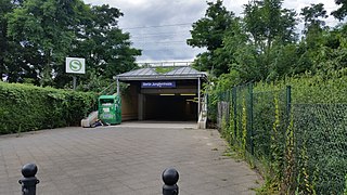
Berlin Jungfernheide is a railway station located at Charlottenburg-Nord, in the Charlottenburg-Wilmersdorf district of Berlin, served by the S-Bahn lines S41 and S42, the U-Bahn line U7 and Regional-Express trains of the Deutsche Bahn. Its name literally translates into "maidens' heathland"; it was named after the Jungfernheide, a former large forest in the proximity of this station.

<span class="mw-page-title-main">Berlin border crossings</span> Post-WWII crossings in divided Berlin, Germany

The Berlin border crossings were border crossings created as a result of the post-World War II division of Germany. Prior to the construction of the Berlin Wall in 1961, travel between the Eastern and Western sectors of Berlin was completely uncontrolled, although restrictions were increasingly introduced by the Soviet and East German authorities at major crossings between the sectors. This free access, especially after the closure of the Inner German border, allowed the Eastern Bloc emigration and defection to occur. East German officials, humiliated by this mass defection, subsequently chose to erect the Berlin Wall in order to prevent residents from leaving East Germany.

<span class="mw-page-title-main">Falkensee</span> Town in Brandenburg, Germany

Falkensee is a town in the Havelland district, Brandenburg, Germany. It is the most populated municipality of its district and it is situated at the western border of Berlin.

<span class="mw-page-title-main">Berlin Stadtbahn</span> Historic railway line in Berlin, Germany

The Berlin Stadtbahn is the historic east-west elevated railway of Berlin. It runs from Friedrichshain in the east to Charlottenburg in the west, connecting several of the most major sights of the German capital. The line is protected cultural heritage since 1995. It is often defined more simply as the slightly longer route between Ostkreuz and Westkreuz, although this is not technically correct.

<span class="mw-page-title-main">Staaken</span> Quarter of Berlin in Germany

Staaken is a locality at the western rim of Berlin within the borough of Spandau.

<span class="mw-page-title-main">Hanover–Berlin high-speed railway</span> German high speed railway

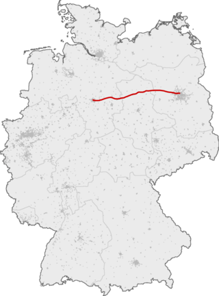
The Hanover–Berlin high-speed railway is a 258-kilometre (160 mi) high-speed rail line linking the German cities of Hanover and Berlin.

<span class="mw-page-title-main">Berlin-Spandau station</span>

Berlin-Spandau station is a Deutsche Bahn station in the Berlin district of Spandau on the south-western edge of the old town of Spandau. The railway junction station is one of the 80 stations classified by Deutsche Bahn as a category 2 station. It has the longest train shed in Germany.

<span class="mw-page-title-main">Dallgow-Döberitz</span> Municipality in Brandenburg, Germany

Dallgow-Döberitz is a municipality in the Havelland district, in Brandenburg, in eastern Germany.

<span class="mw-page-title-main">Potsdam Hauptbahnhof</span> Railway station in Potsdam, Germany

Potsdam Hauptbahnhof is the main station in the German city of Potsdam, capital of the state of Brandenburg. It lies on the Berlin–Magdeburg railway and was founded in 1838. However, it has had this name only since 1999. It was originally called Bahnhof Potsdam and it was called Potsdam Stadt (city) station from 1960. The station is the terminus of line S7 of the Berlin S-Bahn, which comes from Ahrensfelde. It is also connected with the central bus station, which is a transfer point between Potsdam and the southwestern region of Berlin, and has a stop on the Potsdam tram network. It is classified by Deutsche Bahn as a category 2 station.

<span class="mw-page-title-main">Berlin–Hamburg Railway</span> Railway line in Germany

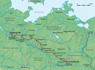
The Berlin–Hamburg Railway is a roughly 286 km (178 mi) long railway line for passenger, long-distance and goods trains. It was the first high-speed line upgraded in Germany to be capable of handling train speeds of over 200 km/h (120 mph).

<span class="mw-page-title-main">Berlin-Albrechtshof station</span>

Berlin-Albrechtshof is a railway station located in Staaken, a locality in the Spandau district of Berlin. It is one of only two Deutsche Bahn stations in Berlin not served by the S-Bahn; Staaken station is the other.

<span class="mw-page-title-main">Wilhelmstadt</span> Quarter of Berlin in Germany

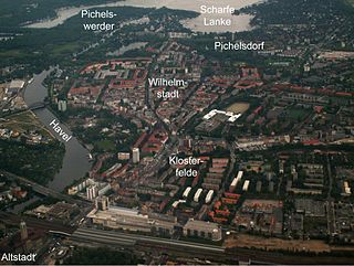
Wilhelmstadt is a German locality (Ortsteil) of Berlin in the borough (Bezirk) of Spandau.

<span class="mw-page-title-main">Berlin–Lehrte railway</span> Major east-west train infrastructure in Germany

The Berlin–Lehrte railway, known in German as the Lehrter Bahn, is an east–west line running from Berlin via Lehrte to Hanover. Its period as a separate railway extended from its opening in 1871 to the nationalisation of its owner, the Magdeburg-Halberstadt Railway Company on 1 July 1886. The company's Berlin station, the Lehrter Bahnhof was finally torn down in 1958.

<span class="mw-page-title-main">Wustermark station</span>

Wustermark station is a railway station in the town of Wustermark in the Havelland region of the German state of Brandenburg, to the west of Berlin. The station is located on the Berlin–Lehrte railway and is connected with the Jüterbog–Nauen railway, part of which became part of the Berlin outer ring in the 1950s. It is classified by Deutsche Bahn as a category 5 station.

<span class="mw-page-title-main">Berlin outer ring</span>

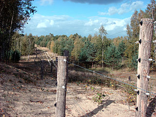
The Berlin outer ring is a 125 km (78 mi) long double track electrified railway, originally built by the German Democratic Republic to bypass West Berlin in preparation for the building of the Berlin Wall during the division of Germany. It was developed by East Germany for economic, transport policy, and military reasons between 1951 and 1961 and included parts of some older lines.

<span class="mw-page-title-main">Rathenow station</span>

Rathenow is a railway station on the Berlin–Lehrte railway located in Rathenow, in the Havelland, Germany. It is used by about 3,300 passengers daily.

<span class="mw-page-title-main">Dallgow-Döberitz station</span>

Dallgow-Döberitz is a railway station located in Dallgow-Döberitz, Germany. The station is located on the Berlin-Lehrte Railway. The train services are operated by Deutsche Bahn and Ostdeutsche Eisenbahn (ODEG).

<span class="mw-page-title-main">Jüterbog–Nauen railway</span>

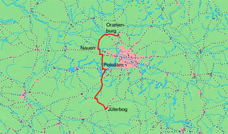
The Jüterbog–Nauen railway is a line that runs to the west of Berlin through the German state of Brandenburg. It runs from Jüterbog via Treuenbrietzen, Beelitz, Potsdam, Wustermark to Nauen. The line is a part of the Bypass Railway (Umgehungsbahn), which was primarily designed to relieve congestion on the railways in Berlin. The Wustermark–Nauen section has been closed, the Golm–Priort section is now a part of the Berlin outer ring and has been rebuilt as a double-track main line.

<span class="mw-page-title-main">History of the Berlin S-Bahn</span>

The Berlin S-Bahn began on 8 August 1924 with the first section from Stettiner Vorortbahnhof to Bernau using steam locomotives. On 13 August 1961 it was broken up when the Berlin Wall was built, resulting in two sections: the eastern part and the western part. The western part experienced a massive strike which resulted in closure of several stations, after declining use. Attempts were made to reopen at various times but in the end, only three lines were finally opened after the strike. Since 9 November 1989, when the Berlin Wall was opened, the Berlin S-Bahn began to expand rapidly with their budgetary costs.

References

  1. Eisenbahnatlas Deutschland (German railway atlas) (2009/2010 ed.). Schweers + Wall. 2009. ISBN   978-3-89494-139-0.
  2. "Stationspreisliste 2024" [Station price list 2024](PDF) (in German). DB Station&Service. 24 April 2023. Retrieved 29 November 2023.
  3. "Der VBB-Tarif: Aufteilung des Verbundgebietes in Tarifwaben und Tarifbereiche" (PDF). Verkehrsbetrieb Potsdam. Verkehrsverbund Berlin-Brandenburg. 1 January 2017. Archived from the original (PDF) on 27 October 2020. Retrieved 29 November 2019.
  4. Timetables for Berlin-Staaken station (in German)

Commons-logo.svg Media related to Berlin-Staaken railway station at Wikimedia Commons