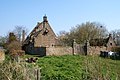
Bern, Netherlands

Last updated
Bern
Zichtopbernnl.jpg
View on Bern
Herpt wapen.svg
2010-NL-P05-Gelderland-positiekaart-gemnamen.jpg
Red pog.svg
Bern
Location in the Netherlands
Netherlands location map.svg
Red pog.svg
Bern
Bern (Netherlands)
Coordinates: 51°44′54″N5°9′55″E / 51.74833°N 5.16528°E / 51.74833; 5.16528 Coordinates: 51°44′54″N5°9′55″E / 51.74833°N 5.16528°E / 51.74833; 5.16528
Country Netherlands
Province Gelderland
Municipality Zaltbommel
Elevation
[1]
5 m (16 ft)
Time zone UTC+1 (CET)
  Summer (DST) UTC+2 (CEST)
Postal code
5318 [2]
Dialing code 0418 [2]

Bern (formerly sometimes "Beern", "Berne", or "Beerne" [3] ) is a hamlet in the Dutch province of Gelderland. It is located in the municipality of Zaltbommel, about 10 kilometres (6.2 miles) south of the town Zaltbommel. [4]

Bern used to lie south of the river Meuse, in the municipality of Herpt en Bern. The river was dammed close to Bern around 1900 (see Afgedamde Maas), and a new channel was dug south of the village, the Bergsche Maas. In 1958, the administrative borders were changed to account for this new situation, and Bern moved from the province of North Brabant to Gelderland, and to the municipality of Kerkwijk.

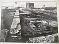
According to the 19th-century historian A.J. van der Aa, [3] there used to be a castle in Bern, with a large tower and surrounded by walls. One of its owners, Fulco of Bern, made the castle into an abbey of the Premonstratensian order in 1134. It was inaugurated by the 25th bishop of Utrecht, Andreas of Cuyk. The abbey suffered during the Iconoclasm in 1566, and was almost completely burnt down in 1589 during the siege of Heusden by the Spanish army. It was never rebuilt, and in the middle of the 19th century, little remained of the Abbey of Bern.

Bern is not a statistical entity, [5] however it has its own postal code. [2] In 1840, it was home to 60 people. Nowadays, it has about 13 houses. [6]

Related Research Articles

Achterhoek, Nijkerk Hamlet in Gelderland, Netherlands

Achterhoek is a hamlet in the Dutch province of Gelderland. It is a part of the municipality of Nijkerk, and lies about 6 km north of Amersfoort.

De Veenhuis Hamlet in Gelderland, Netherlands

De Veenhuis is a hamlet in the Dutch province of Gelderland. It is a part of the municipality of Nijkerk, and lies about 6 km north of Amersfoort.

Bontemorgen is a hamlet in the Dutch province of Gelderland. It is a part of the municipality of Buren, and lies about 7 km south of Veenendaal.

Hoogmeien Hamlet in Gelderland, Netherlands

Hoogmeien is a hamlet in the Dutch province of Gelderland. It is a part of the municipality of Buren, and lies about 8 km northeast of Tiel.

Meertenwei is a hamlet in the Dutch province of Gelderland. It is a part of the municipality of Buren, and lies about 9 km northeast of Tiel.

Zandberg, Gelderland Hamlet in Gelderland, Netherlands

Zandberg is a hamlet in the Dutch province of Gelderland. It is a part of the municipality of Buren, and lies about 9 km northwest of Tiel.

Nederhemert Village in Gelderland, Netherlands

Nederhemert is a village in the Dutch province of Gelderland. It is a part of the municipality of Zaltbommel, and lies about 8 km southwest of that city. Nederhemert was a separate municipality until 1955, when it was merged with Kerkwijk.

Wissel Hamlet in Gelderland, Netherlands

Wissel is a hamlet in the Dutch province of Gelderland. It is located in the municipality of Epe, about 2 km west of the town of Epe.

Kapel is a hamlet in the Dutch province of Gelderland. It is located in the municipality of Lingewaard, about 1 km north of the town of Gendt.

Aam Hamlet in Gelderland, Netherlands

Aam is a hamlet in the Dutch province of Gelderland. It is located in the municipality of Overbetuwe, about 1 km east of the town of Elst. The hamlet is nowadays surrounded by Elst.

Oosterbroek, Drenthe Hamlet in Drenthe, Netherlands

Oosterbroek is a mansion and a former hamlet in the Dutch province of Drenthe. The mansion is located about 2 km east of Eelde, in the municipality of Tynaarlo.

Hollenberg, Netherlands Hamlet in Gelderland, Netherlands

Hollenberg is a hamlet in the Dutch province of Gelderland. It is located in the municipality of Aalten, between Aalten and Bredevoort.

Lijnden, Gelderland Hamlet in Gelderland, Netherlands

Lijnden is a hamlet in the Dutch province of Gelderland. It is located in the municipality of Overbetuwe, about 2 km west of the town of Elst.

Zwolle, Gelderland Hamlet in Gelderland, Netherlands

Zwolle is a hamlet in the province of Gelderland, Netherlands. It is located in the municipality of Oost Gelre, about 3 km southeast of the town of Groenlo.

Californië, Gelderland Hamlet in Gelderland, Netherlands

Californië is a hamlet in the Dutch province of Gelderland. It is located in the municipality of Maasdriel, between the villages Ammerzoden and Hedel.

Anholt, Netherlands Hamlet in Drenthe, Netherlands

Anholt is a hamlet in northeast Netherlands. It is located in the municipality De Wolden, Drenthe, about 2 km west of Pesse.

Appel, Netherlands Hamlet in Gelderland, Netherlands

Appel is a hamlet in the Dutch province of Gelderland. It is located in the municipality Nijkerk, about 6 km southeast of the city, on the border with the municipality of Barneveld.

Appen is a hamlet in the Dutch province of Gelderland. It is located in the municipality of Voorst, about 0.5 km southwest of Gietelo, to which it belongs.

Baal, Netherlands Hamlet in Gelderland, Netherlands

Baal is a hamlet in the Dutch province of Gelderland. It is located in the municipality of Lingewaard, about 1 km northeast of Bemmel, and located 1 kilometer north of Haalderen and is therefore part of Haalderen.

Bahr is a hamlet in the Dutch province of Gelderland. It is located in the municipality Zevenaar, about 3 km southeast of Rheden.

References

  1. "Postcodetool for 5318LA". Actueel Hoogtebestand Nederland (in Dutch). Het Waterschapshuis. Retrieved 25 March 2022.
  2. 1 2 3 "Postcode 5318 in Bern". Postcode bij adres (in Dutch). Retrieved 25 March 2022.
  3. 1 2 Abraham Jacob van der Aa , "Aardrijkskundig woordenboek der Nederlanden", vol. 2 (B), 1840 .
  4. ANWB Topografische Atlas Nederland, Topografische Dienst and ANWB, 2005.
  5. "Kerncijfers wijken en buurten 2021". Central Bureau of Statistics. Retrieved 25 March 2022. not found
  6. "Plaatsengids" (in Dutch). Retrieved 25 March 2022.