
The Adur is a river in Sussex, England; it gives its name to the Adur district of West Sussex. The river, which is 20 miles (32 km) long, was once navigable for large vessels up as far as Steyning, where there was a large Saxon port, but by the 11th century the lower river became silted up and the port moved down to the deeper waters at the mouth of the river in Shoreham-by-Sea.

Steyning is a town and civil parish in the Horsham district of West Sussex, England. It is located at the north end of the River Adur gap in the South Downs, four miles (6.4 km) north of the coastal town of Shoreham-by-Sea.

Henfield is a large village and civil parish in the Horsham District of West Sussex, England. It lies 41 miles (66 km) south of London, 12 miles (19 km) northwest of Brighton, and 30 miles (48 km) east northeast of the county town of Chichester at the road junction of the A281 and A2037. The parish has a land area of 4,285 acres (1,734.1 ha). In the 2001 census 5,012 people lived in 2,153 households, of whom 2,361 were economically active. Other nearby towns include Burgess Hill to the east and Shoreham-by-Sea to the south. The population at the 2011 Census was 5,349.
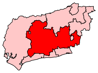
Arundel and South Downs is a constituency in West Sussex created in 1997 and represented in the House of Commons of the UK Parliament since 2019 by Andrew Griffith of the Conservative Party.

Preston Park railway station is on the Brighton Main Line in England, serving Preston Village and the northern suburban areas of the city of Brighton and Hove, East Sussex. It is 49 miles 21 chains (79.3 km) from London Bridge via Redhill, between Hassocks and Brighton.

Hassocks railway station is on the Brighton Main Line in England, serving the village of Hassocks, West Sussex. It is 43 miles 42 chains (70.0 km) down the line from London Bridge via Redhill and is situated between Burgess Hill and Preston Park. It is managed by Southern.

Wivelsfield railway station is a railway station on the Brighton Main Line in West Sussex, England. Located in northern Burgess Hill, it primarily serves the town's neighbourhoods of World's End and Sheddingdean. The station is 40 miles 52 chains (65.4 km) down the line from London Bridge via Redhill. It is situated between Haywards Heath and Burgess Hill stations on the main line, and between Haywards Heath and Plumpton stations on the East Coastway line, which branches off just south of the station at Keymer Junction. The station is managed by Southern which is one of two companies serving Wivelsfield, the other one being Thameslink. Until May 2018, Gatwick Express also served the station with a single early-morning service each weekday towards London.
Albourne is a village and civil parish in the Mid Sussex district of West Sussex, England. It lies just off the A23 road three miles (4.8 km) east of Henfield. The parish has a land area of 772.9 hectares (1909 acres). In the 2001 census 600 people lived in 234 households, of whom 321 were economically active. The population at the 2011 Census was 644. The name comes from an alder-lined stream, which is likely to have been the Cutler's Brook.

Dorking railway station is a railway station in Dorking, Surrey, England. Located on the Mole Valley line, it is 22 miles 8 chains (35.6 km) down the line from London Waterloo. The station is one of three that serve the town of Dorking, alongside Dorking Deepdene and Dorking West stations. Dorking and Dorking Deepdene stations are within walking distance of each other and interchange between them on a through ticket is permitted.

Woodmancote is a village and civil parish in the Horsham District of West Sussex, England. The village is 1 mile (1.5 km) southeast of Henfield on the A281 road. It should not be confused with the other West Sussex village of Woodmancote near Chichester.

The Downs Link is a 36.7 miles (59.1 km) path and bridleway linking the North Downs Way at St. Martha's Hill in Surrey with the South Downs Way near Steyning in West Sussex and on via the Coastal Link to Shoreham-by-Sea.
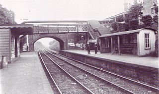
The Steyning Line was a railway branch line that connected the West Sussex market town of Horsham with the port of Shoreham-by-Sea, with connections to Brighton. It was built by the London, Brighton and South Coast Railway, and opened in 1861. It was 20 miles in length. It followed the course of the River Adur for much of its extent and was alternatively known as the Adur Valley Line.

Partridge Green is a village in the Horsham District of West Sussex, England. It lies on the B2135 road 2.5 miles (4 km) north-west of Henfield. It is in the parish of West Grinstead.

Southwater was a railway station on the Steyning Line which served the village of Southwater. A goods siding allowed for the transportation of coal and other raw materials to and from Southwater Brickworks.
West Grinstead was a railway station on the Steyning Line which served the village of West Grinstead. It had a goods yard with a cattle loading bay and facilities for handling horse boxes. With the hunt kennels and national stud based in the area, the station saw substantial horse traffic.

Partridge Green was a railway station on the Steyning Line which served the village of Partridge Green.

Henfield was a railway station on the Steyning Line which served the village of Henfield. It was equipped with a siding which received coal to serve the Steam Mill and Gas Works.

Steyning railway station was on the Steyning Line which served the small market town of Steyning.

Bramber was a railway station in England on the Steyning Line which served the village of Bramber. The station was patronised by tourists visiting nearby Bramber Castle, Potter's Museum and the village. In order to accommodate the special excursion trains the station platforms were extra long.

Bramber Castle is an electoral division of West Sussex in the United Kingdom and returns one member to sit on West Sussex County Council.
