
Luce County is a county located in the Upper peninsula in the U.S. state of Michigan. As of the 2010 census, the population was 6,631, making it the second-least populous county in Michigan. The county seat is Newberry. The county was set off and organized in 1887 and named after former Michigan Governor Cyrus G. Luce.
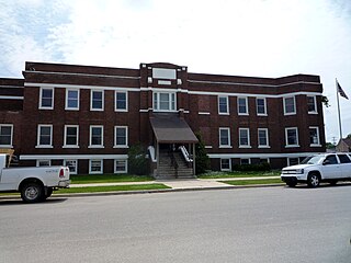
Newberry is a village and county seat of Luce County in the U.S. state of Michigan. The village is located within McMillan Township and is the only incorporated community in Luce County. The population was 1,519 at the 2010 census.

Albee Township is a civil township of Saginaw County in the U.S. state of Michigan. As of the 2010 Census, the township population was 2,160. Albee Township was established in 1863.
Lake Township is the name of some places in the U.S. state of Michigan:

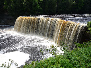
The Tahquamenon Falls State Park is a 46,179-acre (186.88 km2) state park in the U.S. state of Michigan. It is the second largest of Michigan's state parks. Bordering on Lake Superior, most of the park is located within Whitefish Township in Chippewa County, with the western section of the park extending into McMillan Township in Luce County. The nearest town of any size is Paradise.
M-123 is a state trunkline highway in the eastern Upper Peninsula of the U.S. state of Michigan. It is one of only a few highways in Michigan that curve around and form a U-shape. In fact, M-123 has three intersections with only two state trunklines; it meets M-28 twice as a result of its U-shaped routing. M-123 also has a rare signed concurrency with a County-Designated Highway in Michigan; in Trout Lake, there is a concurrency with H-40. All of M-123 north of M-28 is a Scenic Heritage Route within the Michigan Heritage Route system.
The Tahquamenon River is an 89.1-mile-long (143.4 km) blackwater river in the U.S. state of Michigan that flows in a generally eastward direction through the eastern end of the Upper Peninsula. It drains approximately 820 square miles (2,120 km2) of the Upper Peninsula, including large sections of Luce County and Chippewa County. It begins in the Tahquamenon Lakes in northeast Columbus Township of Luce County and empties into Lake Superior near the village of Paradise. M-123 runs alongside a portion of the river.

Cyrus Gray Luce was an American politician in the U.S. state of Michigan. He served as the 21st Governor of the US state of Michigan.

Muskallonge Lake State Park is a public recreation area on Lake Superior sixteen miles (26 km) east of Grand Marais in Luce County, Michigan. The state park covers 217 acres (88 ha) between the shores of Lake Superior and Muskallonge Lake where Native American's once had an encampment and where a station of the United States Life-Saving Service once stood.
The Shelldrake River is a 32-mile-long (51 km) river in Chippewa County on the Upper Peninsula of Michigan in the United States. It flows through Tahquamenon Falls State Park and the Lake Superior State Forest into Lake Superior.
Devils Lake is the name of a few lakes in the U.S. state of Michigan.
H-33 is a county-designated highway in the Upper Peninsula of the US state of Michigan between Gould City and McMillan that was previously M-135, a former state trunkline highway. The roadway follows Manistique Lakes Road from Gould City at a junction with US Highway 2 (US 2) near Lake Michigan north to M-28 near McMillan. The northern section of the highway is also called County Road 135 (CR 135) in Luce County.

The Manistique River is a 71.2-mile-long (114.6 km) river in the U.S. state of Michigan that winds southward through the central Upper Peninsula from its headwaters near Lake Superior to its mouth in Lake Michigan. It drains approximately 1,461 square miles (3,780 km2) of the Upper Peninsula, including most of Schoolcraft County and small portions of Alger County, Delta County, Luce County, and Mackinac County. The river rises at the outlet of Manistique Lake in the southwest corner of Luce County, and after flowing through the Seney National Wildlife Refuge, empties into Lake Michigan at Manistique, Michigan. M-77, a north-south highway, serves much of the Manistique River's drainage and crosses the river and its tributaries several times.

Deer Park is an unincorporated community in Luce County in the U.S. state of Michigan. Deer Park is located within McMillan Township on the coast of Lake Superior near Muskallonge Lake State Park.
Manistique Lake, locally called Big Manistique Lake to distinguish it from the other lakes in the Manistique Lakes system, is a 10,130-acre (4,100 ha) lake in the Upper Peninsula of the U.S. state of Michigan. Approximately 6.5 miles (10.5 km) long and 4 miles (6.4 km) wide, it is one of the largest lakes in the Upper Peninsula. Elevated 686 feet (209 m) above sea level and 105 feet (32 m) above Lake Michigan, Lake Manistique drains into the larger lake through a marshy outlet on the west end of the lake that forms one source of the Manistique River. Relatively shallow, the lake's deepest point is only 20 feet (6.1 m) below the water surface. The average depth is 10 feet (3.0 m).
Betsy is a feminine given name.
Carp River is the name of several rivers in the U.S. state of Michigan.
The Duck Lake Fire occurred north of the Village of Newberry in Luce County, Michigan in the eastern half of the Upper Peninsula of Michigan. The fire started with a lightning strike on Wednesday, May 23, 2012 near Duck Lake. The Duck Lake Fire was reported 100% contained by the Michigan DNR on 15 June 2012 with 21,135 acres burned. The Duck Lake Fire was reported as the third worst fire in Michigan since 1881. It was the second major fire in Luce County within five years. On May 25, 2012, Governor Rick Snyder declared a state of disaster in Luce and Schoolcraft counties, which included a ban of fireworks and an outdoor burning ban in 49 counties, including all counties located in the Upper Peninsula and much of the northern half of the Lower Peninsula as a result of abnormally dry conditions. The fire caused the closure of Tahquamenon Falls State Park during the Memorial Day weekend. Blueberries grow well here.
