
The Lycian Way is a marked long-distance hiking trail in southwestern Turkey around part of the coast of ancient Lycia. It is approximately 520 km (320 mi) in length and stretches from Hisarönü (Ovacık), near Fethiye, to Aşağı Karaman in Konyaaltı, about 20 km (12 mi) from Antalya. It is waymarked with red and white stripes of the GR footpath convention.
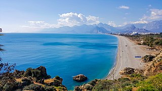
Antalya Province is a province and metropolitan municipality of Turkey. It is located on the Mediterranean coast of south-west Turkey, between the Taurus Mountains and the Mediterranean Sea. Its area is 20,177 km2, and its population is 2,688,004 (2022).

Phaselis or Faselis was a Greek and Roman city on the coast of ancient Lycia. Its ruins are located north of the modern town Tekirova in the Kemer district of Antalya Province in Turkey. It lies between the Bey Mountains and the forests of Olympos National Park, 16 kilometres (9.9 mi) south of the tourist town of Kemer and on the 57th kilometre of the Antalya–Kumluca highway. Phaselis and other ancient towns around the shore can also be accessed from the sea by daily yacht tours.

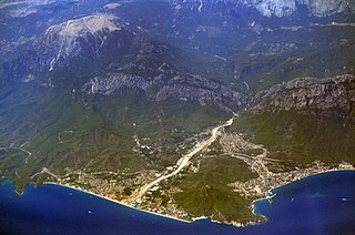
Kemer is a seaside resort, municipality and district of Antalya Province, Turkey. Its area is 412 km2, and its population is 49,383 (2022). It is on the Mediterranean coast, 43 km (27 mi) west of the city of Antalya, on the Turkish Riviera.

Kumluca is a municipality and district of Antalya Province, Turkey. Its area is 1,225 km2, and its population is 73,496 (2022). It lies on the Mediterranean coast, and is part of the Turkish Riviera. Kumluca is located 90 km (56 mi) west of the city of Antalya, on the Teke Peninsula,. Its neighbour towns are Korkuteli, Elmalı, Finike, Kemer and Antalya
Çamyuva is a neighbourhood of the municipality and district of Kemer, Antalya Province, Turkey. Its population is 6,067 (2022). Before the 2013 reorganisation, it was a town (belde).

The Turkish Riviera, also known popularly as the Turquoise Coast, is an area of southwest Turkey encompassing the provinces of Antalya and Muğla, and to a lesser extent Aydın, southern İzmir and western Mersin. The combination of a favorable climate, warm sea, mountainous scenery, fine beaches along more than a 1,000 km (620 mi) of shoreline along the Mediterranean and Aegean waters, and abundant natural and archaeological points of interest makes this stretch of Turkey's coastline a popular national and international tourist destination.

Çıralı is an agricultural village in southwest Turkey, in the Kemer district of Antalya Province. It is walking distance from the ancient ruins of Olympos and Chimaera permanent gas vents, located in the ancient Lycia region of Anatolia.
Ulupınar is a neighbourhood of the municipality and district of Kemer, Antalya Province, Turkey. Its population is 1,315 (2022).
The Mediterranean Region is a geographical region of Turkey. The largest city in the region is Antalya. Other big cities are Adana, Mersin, Isparta, Antakya and Kahramanmaraş.
Beldibi is a neighbourhood of the municipality and district of Kemer, Antalya Province, Turkey. Its population is 3,376 (2022).

Göynük is a neighbourhood of the municipality and district of Kemer, Antalya Province, Turkey. Its population is 7,868 (2022). Before the 2013 reorganisation, it was a town (belde). The town is inhabited by Tahtacı.
Ovacık is a neighbourhood of the municipality and district of Kemer, Antalya Province, Turkey. Its population is 149 (2022).

Tekirova is a neighbourhood of the municipality and district of Kemer, Antalya Province, Turkey. Its population is 3,044 (2022). Before the 2013 reorganisation, it was a town (belde).

Beydağları Coastal National Park, a.k.a. Olympos Beydagları National Park, is a national park in Antalya Province, southern Turkey.
Beycik may refer to the following places in Turkey:

The Olympos Aerial Tram, aka Olympos Cable Car, is an aerial lift of tramway type located in Antalya Province, southern Turkey, serving the peak of Mount Olympos at an altitude of 2,365 m (7,759 ft) from Kemer. It went into service in 2006.

Tahtalı Dağı, also known as Lycian Olympus, is a mountain near Kemer, a seaside resort on the Turkish Riviera in Antalya Province, Turkey. It was known as Olympus and Phoenicus or Phoinikous in ancient times. It is part of the Beydağları Coastal National Park. Visitors can ascend the summit with the Olympos Aerial Tram. The Lycian Way long distance trail traverses the mountain.

Göynük Canyon is a canyon in Antalya Province, southwestern Turkey.

Teke Peninsula, also known as Teke Region, is a peninsula located in southwestern Turkey between the gulfs of Antalya and Fethiye extending into the Mediterranean Sea. It is bordered to the Turkish Lakes Region in the north.

