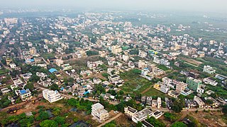
Akividu is a town in West Godavari district of Andhra Pradesh, India. It is a nagara panchayati (municipality) and the mandal headquarters of Akiveedu mandal in Bhimavaram revenue division. Akiveedu is a sixth biggest town in former West Godavari district between the cities of Bhimavaram and Eluru.
Buttayagudem is a village in the Eluru district of the Indian state of Andhra Pradesh. The nearest railway station is Kaikaram(KKRM) located at a distance of 40.26 Km.
Iraga-varam is a village in the West Godavari district of the Indian state of Andhra Pradesh. It is located in Iragavaram mandal in Narsapuram revenue division. The nearest railway station is Velpuru (VPU) located at a distance of 7 km.
Peravali is a village in East Godavari district of the Indian state of Andhra Pradesh. The nearest railway station is Tanuku (TNKU) located at a distance of 7.25 Km. Postal index code of this village is 534328
Khandavalli is a village in Peravali mandal in West Godavari district, Andhra Pradesh. Postal Index Code of this village is 534330.
Gundugolanu, an alliteration of the Telugu word "Gurukolanu" (school)' is a village in Eluru district of the Indian state of Andhra Pradesh. It is located in Bhimadole mandal. The nearest train station is Bhimadolu railway station located at a distance of 4.9 km.
Eluru mandal is one of the 28 mandals in Eluru district of the Indian state of Andhra Pradesh. It is administered under Eluru revenue division and its headquarters are located at Eluru city. The mandal is bounded by Pedapadu mandal, Pedavegi mandal, Denduluru mandal, Bhimadole mandal and it also borders Krishna district.
Bhogolu is a village in West Godavari district of the Indian state of Andhra Pradesh. It is located in Lingapalem mandal of Eluru revenue division. Eluru is the nearest railway station which is located more than 10 km.

Pulla is a village in Eluru district of the Indian state of Andhra Pradesh. It is situated in Bhimadole mandal of Eluru revenue division.

Tangellamudi is a census town in Eluru district of the Indian state of Andhra Pradesh. It is in Eluru mandal of Eluru revenue division. The town is a constituent of Eluru urban agglomeration. The nearest railway station is in Powerpet and is 1.5 km.
Guntupalle is a village in Eluru District of the Indian state of Andhra Pradesh. It is located in Kamavarapukota mandal of Eluru revenue division. It is located at a distance of 42 km from district headquarters Eluru city. It is well known tourist destination famously known for Guntupalli caves. The nearest train station is Eluru railway station.
Dwaraka Tirumala mandal is one of the 28 mandals in Eluru district of the Indian state of Andhra Pradesh. It is under the administration of Eluru revenue division, and the headquarters are located at Dwaraka Tirumala. The mandal is bounded by Jangareddygudem, Koyyalagudem, Kamavarapukota, Nallajerla, Pedavegi, Unguturu, Denduluru and Bhimadole mandals.
Gogunta is a village in Eluru district of the Indian state of Andhra Pradesh. It is located in Pedapadu mandal of Eluru revenue division. Nuzvid railway station is the nearest railway station.
Jalipudi is a village in Eluru district of the Indian state of Andhra Pradesh. It is located in Eluru mandal of Eluru revenue division. The town is a constituent of Eluru urban agglomeration.
Ponangi is a village in Eluru district of the Indian state of Andhra Pradesh. It is located in Eluru mandal of Eluru revenue division. The nearest railway station is located at Eluru.
Edulakunta is a village in Eluru district of the Indian state of Andhra Pradesh. It is located in Pedapadu mandal of Eluru revenue division. Kamareddi railway Station is the nearest train station located at a distance of more than 10Km.
Kokkirapadu is a village in Eluru district of the Indian state of Andhra Pradesh. It is located in Pedapadu mandal of Eluru revenue division. The nearest railway station is at Vatlur (VAT) located at a distance of 4.4 km.
Koniki is a village in Eluru district of the Indian state of Andhra Pradesh. It is located in Pedapadu mandal of Eluru revenue division. The nearest railway station is located at Chirala which is more than 10 km from Koniki.
Amberpeta is a village in Eluru district in the state of Andhra Pradesh in India. The nearest railway station is Kacheguda(KCG) located at a distance of 0.81 Km.
Unguturu mandal is one of 28 mandals in the Eluru district of the Indian state of Andhra Pradesh. The headquarters are located at Unguturu. The mandal is bordered by Tadepalligudem mandal and Pentapadu mandal to the north, Nallajerla mandal to the west, Nidamarru mandal to the east, and by Dwaraka Tirumala mandal and Bhimadole mandal to the south


