
Osmanabad District, officially known as Dharashiv District, is an administrative district in the Marathwada region in the Indian state of Maharashtra. The district headquarter is located at Osmanabad. The District of Osmanabad derives its name from the last ruler of Hyderabad, the 7th Nizam, Mir Osman Ali Khan, of which the region was a part till 1947. This region was earlier part of The Hyderabad State until Independence.This primarily rural district occupies an area of 7,569 km2 (2,922 sq mi) of which 241.4 km2 (93.2 sq mi) is urban and has a population of 1,657,576 of which 16.96% were urban.

The Wainganga is a river in India originating in the Mahadeo Hills in Mundara in Gondwana region near the village Gopalganj in Seoni, Madhya Pradesh. It is a key tributary of the Godavari. The river flows south in a winding course through the states of Madhya Pradesh and Maharashtra, roughly 580 km (360 mi). After joining the Wardha River, the united stream, which is known as the Pranahita River, empties into the Godavari River at Kaleshwaram, Telangana.

The Bhima River is a major river in Western India and South India. It flows southeast for 861 kilometres (535 mi) through Maharashtra, Karnataka, and Telangana states, before joining the Krishna River. After the first sixty-five kilometers in a narrow valley through rugged terrain, the banks open up and form a fertile agricultural area which is densely populated.

Balaghat district is a district of Madhya Pradesh state in Central India. Its belongs to Jabalpur Division. Balaghat city is Administrative Headquarter of Balaghat District.
Pune Division is one of the six administrative divisions of the Indian State of Maharashtra. Pune Division is bound by Konkan Division to the west, Nashik Division to the north, Aurangabad Division to the east, and the state of Karnataka to the south.

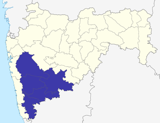
Solapur District is a district in Maharashtra state of India. The city of Solapur is the district headquarters. It is located on the south east edge of the state and lies entirely in the Bhima and Seena basins. The entire district is drained by the Bhima River.
Vairag is a town in Barshi Taluka of Solapur district in Maharashtra, India. The village is located centrally between Solapur and Barshi.

Ujjani Dam, also known as Bhima Dam or Bhima Irrigation Project, on the Bhima River, a tributary of the Krishna River, is an earthfill cum Masonry gravity dam located near Ujjani village of Madha Taluk in Solapur district of the state of Maharashtra in India.
Madha is a city in the municipal council of Madha Taluka, in Solapur district in the Indian state of Maharashtra. It belongs to Solapur Division. It is located 70 km towards North-West from district headquarters Solapur. Madha is also known for the Madheshawari temple, situated near Mankarna river. The historic temple of Lord Vitthal is in Madha City. Madha Fort built by Raje Nimbalkar is a big attraction in the city.
Maharashtra State Highway 151, commonly referred to as SH 151, is a state highway that runs south through Solapur district in the state of Maharashtra. This state highway touches the cities of Barshi – Vairag – Solapur – Akkalkot and then proceeds south towards Maharashtra-Karnataka state border.

North Solapur Taluka is one of the 11 tehsils of Solapur District in the Indian state of Maharashtra. This tehsil is located in the eastern side of district and is bordered by Osmanabad District to the northeast, South Solapur to the south and east, Barshi Taluka to the north and Mohol Taluka to the west. The tehsil headquarters is located at Solapur, which is also the district headquarters and its largest city.

Barshi Taluka is one of the 11 talukas of Solapur District in the Indian state of Maharashtra. This tehsil occupies the Northeast corner of the district and is bordered by Osmanabad District to the north and east, Madha Taluka to the west, Mohol Taluka to the southwest and North Solapur Taluka to the south. The tehsil headquarters is located at Barshi, which is also the largest city in the tehsil.
Sina River is a large tributary of the Bhima river which is starting near Ahmednagar city. It has two chief sources, one near Jamgaon about 20 km. west of the town of Ahmednagar and the other near Sasewadi,Jeur about 16 km. to its north-east. For a distance of about 55 km. roughly, the river forms boundary between Ahmadnagar District on the one hand and Beed district on the other. On the right, it receives the waters of Mahekri, and ultimately joins the Bhima on the Karnataka State border. It has earth filled Sina Dam near Karjat in Ahmadnagar District.

Kurduvadi Junction is a railway station located in Solapur district in the Indian state of Maharashtra and serves Kurduvadi. It is a junction station at the intersection point of Mumbai–Chennai line and Latur road–Miraj line. Kurduvadi Workshop is located next to the station.

The Solapur–Guntakal section is part of the Mumbai–Chennai line. It connects Solapur in the Indian state of Maharashtra and Guntakal in Andhra Pradesh.
Shetphal is a village in the Mohol taluka of Solapur district in Maharashtra state, India. According to Census 2011 information, the location code or village code of Shetphal village is 562192. It is situated 24km away from sub-district headquarter Mohol and 69km away from district headquarter Solapur. As per 2009 stats, Shetphal village is also a gram panchayat. The total geographical area of village is 3089 hectares. Kurduvadi is nearest town to shetphal for all major economic activities, which is approximately 22km away.
Tulsidas Jadhav was an Indian freedom fighter, political activist, social worker, farmer and member of Bombay Legislative Council and Lok Sabha.

Sindphana is a minor tributary of Godavari river that originates around the Chincholi hill in Patoda Taluka, Beed District, Maharashtra, in India. Crossing west to east its drainage basin covers nearly 80% of Beed District, making it the most important river within the district. The Majalgaon Dam, constructed across the river, irrigates 93885 hectares of land in Beed, Parbhani & Nanded districts.

Laul, also known as Sant Shri Kurmadas Maharaj Village, is a village located in Madha Taluka of Solapur District in the State of Maharashtra, in India. It belongs to the Pune Division. It is located 81 km towards west from District headquarter Solapur. It is situated from Kurduvadi Junction(6 km). The village is located at about 380 km from the state capital, Mumbai. Kurdu (5 km), Ghatane (6 km), Ujani Madha (6 km), Padsali (7 km), Ambad (Te) (7 km) are the nearby Villages to Laul. Laul is surrounded by Paranda Taluka towards North, Mohol Taluka towards East, Barshi Taluka towards East, Indapur Taluka towards west. Pandharpur, Kurduvadi, Solapur, Osmanabad are the nearby Cities to Laul. The village follows the Panchayati raj system. Also has a railway track, which used to travel by few people.
Dahitane is a village in the Barshi Taluka of Solapur district in Maharashtra, India. It is a village panchayat located between the town of Vairag and the tehsil of Mohol.