Bhoja Chak

Last updated

Bhoja Chak
Village
Behea block map.png
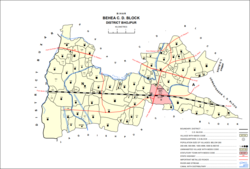
Map of Bhoja Chak (#159) in Behea block
India Bihar location map.svg
Red pog.svg
Bhoja Chak
Location in Bihar, India
India location map.svg
Red pog.svg
Bhoja Chak
Bhoja Chak (India)
Coordinates: 25°33′57″N84°28′06″E / 25.56589°N 84.4684°E / 25.56589; 84.4684 [1]
CountryIndia
State Bihar
District Bhojpur
Area
[2]
  Total0.043 km2 (0.017 sq mi)
Elevation
[1]
62 m (203 ft)
Population
 (2011)
  Total316 [2]
Languages
  Official Bhojpuri, Hindi
Time zone UTC+5:30 (IST)

Bhoja Chak is a small village in Bihiya block of Bhojpur district in Bihar, India. As of 2011, its population was 316, in 57 households. It is located just northeast of the town of Bihiya. [2]

Related Research Articles

<span class="mw-page-title-main">Arrah</span> City in Bihar, India

Arrah is a city and a municipal corporation in Bhojpur district in the Indian state of Bihar. It is the headquarters of Bhojpur district, located near the confluence of the Ganges and Sone rivers, some 24 mi (39 km) from Danapur and 36 mi (58 km) from Patna.

<span class="mw-page-title-main">Behea, Bihar</span> Town in Bihar, India

Behea or Bihiya is a nagar panchayat town and Block in Bhojpur district in the Indian state of Bihar. The Behea block comprises 76 rural villages, along with the town of Bihiya itself and 22 uninhabited villages. As of 2011, the population of the Behea block was 1,51,722 of whom 26,707 lived in the town of Behea itself.

<span class="mw-page-title-main">Shahpur, Bihar</span> Town in Bihar, India

Shahpur is a town and a notified area in Bhojpur district in the Indian state of Bihar.

<span class="mw-page-title-main">Bhojpur district, India</span> District of Bihar in India

Bhojpur district is one of the thirty-eight districts of the Indian state of Bihar. Arrah town is the administrative headquarters of this district. Bhojpur district came into existence in 1972. Earlier it was the part of Shahabad district. This district is named "Bhojpur" after great Parmara King Bhoja as most early settlers were Rajput rulers of Parmara dynasty then called as Ujjainiya.

<span class="mw-page-title-main">Bhojpur Kadim</span> Village in Bihar, India

Bhojpur Kadim is a historic village in Dumraon block of Buxar district, Bihar, India. As of 2011, its population was 18,243, in 3,024 households. Together with the neighboring Bhojpur Jadid, it lends its name to the surrounding Bhojpuri region.

<span class="mw-page-title-main">Kazi Chak, Barhara</span> Village in Bihar, India

Kazi Chak is a village in Barhara block of Bhojpur district in Bihar, India. As of 2011, its population was 1,349, in 224 households.

<span class="mw-page-title-main">Phulai, Bhojpur</span> Village in Bihar, India

Phulai is a village in the southern part of Bihiya block in Bhojpur district, Bihar, India. As of 2011, its population was 955, in 135 households.

<span class="mw-page-title-main">Chakwath</span> Village in Bihar, India

Chakwath is a village in Bihiya block of Bhojpur district, Bihar, India. As of 2011, its population was 4,964, in 760 households.

<span class="mw-page-title-main">Khakhu Bandh</span> Village in Bihar, India

Khakhu Bandh is a small village in the southern part of Bihiya block in Bhojpur district, Bihar, India. As of 2011, its population was 426, in 56 households.

<span class="mw-page-title-main">Osain, Bhojpur</span> Village in Bihar, India

Osain is a village in the west-central part of Bihiya block in Bhojpur district, Bihar, India. As of 2011, its population was 6,308, in 966 households.

<span class="mw-page-title-main">Mahuaon</span> Village in Bihar, India

Mahuaon is a village in the southern part of Bihiya block, in Bhojpur district, Bihar, India. As of 2011, its population was 3,093, in 457 households.

<span class="mw-page-title-main">Hirdepur, Bihiya</span> Village in Bihar, India

Hirdepur is a small village in Bihiya block of Bhojpur district in Bihar, India. As of 2011, its population was 294, in 39 households. It is located west of the town of Bihiya.

<span class="mw-page-title-main">Jamua, Bihiya</span> Village in Bihar, India

Jamua is a village in the Bihiya block of Bhojpur district in Bihar, India. As of 2011, its population was 2,308, in 306 households. It is located just northwest of the town of Bihiya.

<span class="mw-page-title-main">Andar, Bhojpur</span> Village in Bihar, India

Andar is a village in Bihiya block of Bhojpur district in Bihar, India. As of 2011, its population was 1,790, in 265 households.

<span class="mw-page-title-main">Dubauli, Bihiya</span> Village in Bihar, India

Dubauli is a small village in Bihiya block of Bhojpur district in Bihar, India. As of 2011, its population was 224, in 33 households. It is located a short distance northwest of the town of Bihiya.

<span class="mw-page-title-main">Teghra, Bihiya</span> Village in Bihar, India

Teghra is a village in Bihiya block of Bhojpur district in Bihar, India. As of 2011, its population was 3,049, in 420 households. It is located northeast of Bihiya, at a crossroads, with one road running north–south from Jhaua to Jagdishpur and the other running east–west from Arrah to Shahpur.

<span class="mw-page-title-main">Tiar, Bhojpur</span> Village in Bihar, India

Tiar is a village in the southwestern corner of Bihiya block in Bhojpur district, Bihar, India. As of 2011, its population was 4,338, in 663 households.

<span class="mw-page-title-main">Jadopur, Bihiya</span> Village in Bihar, India

Jadopur is a village in the south-central part of Bihiya block of Bhojpur district, Bihar, India. As of 2011, its population was 2,923, in 417 households.

<span class="mw-page-title-main">Danwan</span> Village in Bihar, India

Danwan is a large village in Jagdishpur block of Bhojpur district, Bihar, India. It is located in the northern part of the block, near the border with Bihiya block. As of 2011, its population was 14,523, in 2,481 households.

<span class="mw-page-title-main">Hardiya, Jagdishpur</span> Village in Bihar, India

Hardiya is a village in Jagdishpur block of Bhojpur district, Bihar, India. It is located in the northern part of the block, near the border with Bihiya block. As of 2011, its population was 6,998, in 1,006 households.

References

  1. 1 2 "Geonames.org. Bhoja Chak" . Retrieved 18 August 2020.
  2. 1 2 3 "Census of India 2011: Bihar District Census Handbook - Bhojpur, Part A (Village and Town Directory)". Census 2011 India. pp. 436–475. Retrieved 18 August 2020.