
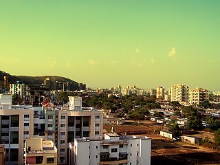
Kothrud is an upmarket residential neighborhood in the city of Pune.
Pashan is suburb of Pune, India. It is located off the Mumbai-Bangalore national highway, by-passing Pune city. Pashan road serves as the main approach road for Mumbai-Pune expressway. Pashan is bordered by Baner in north, Sus on west, Bavdhan in south and Pune University in east. It was majorly developed by the D R Kulhalli Company. Pashan is mostly a residential suburb of Pune and large portions are occupied by various governmental and educational institutions. In October 2019, Pashan received more rainfall than the wettest place on Earth.
Warje is a suburb of Pune, in the Indian state of Maharashtra. A former village, it was incorporated into the city in 2001.

Shivajinagar Assembly constituency is one of the twenty one constituencies of Maharashtra Legislative Assembly located in Pune district, and one of eight in Pune City.

Kothrud Assembly constituency is one of the 288 Maharashtra Vidhan Sabha (Assembly) constituencies of Maharashtra state in Western India. It is one of the twenty one constituencies of located in the Pune district and one of eight in Pune City.
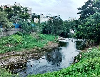
The Ramnadi is a river in Pune District and is a tributary of the Mula. It originates in the Sahyadris near Khatpewadi, north-west of Pune city. The river flows through the Bhugaon, Bhukum, Bavdhan, Pashan, Baner and Aundh areas of Pune city. It is defined as a brook by the Pune Municipal Corporation (PMC).
Pune Monorail refers to several proposed monorail system for the city of Pune, India. As of 2024, none have come to fruition, with the Pune Metro opening in 2022 instead.
Pimple Gurav is a neighbourhood situated on the banks of River Pavana in the city of Pune, India.

Sahyadri Hospitals is a chain of hospitals in Maharashtra, India.
Bavdhan is a residential suburb, situated in the southwestern part of Pune, in the Indian state of Maharashtra.

Khadakwasla is one of the 288 Vidhan Sabha constituencies of Maharashtra state, western India. This constituency is located in Pune district.
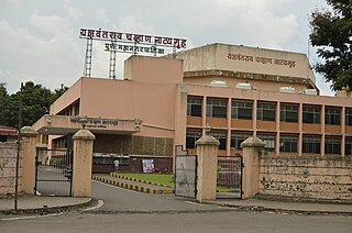
Yashwantrao Chavan Natya Gruha is a theatre auditorium and exhibition hall located in Kothrud, Pune. The theater is named after first Chief Minister of Maharashtra after the division of Bombay State and the fifth Deputy Prime Minister of India Yashwantrao Chavan. It is run by Pune Municipal Corporation and was established in 2000 with the capacity of 900 persons with a parking facilities of 60 four-wheelers and 125 two-wheelers.
Manavya is a non-governmental organization (NGO) in India, founded by Vijaya Lawate, for rehabilitating children and women affected by HIV/AIDS.
Medha Vishram Kulkarni is an Indian politician and member of the Bharatiya Janata Party.
Chandrakant Mokate is an Indian politician and member of the Shiv Sena (UBT). He was a member of the Maharashtra Legislative Assembly from the Kothrud assembly constituency in Pune.
Bhavani Peth Assembly constituency was one of the 288 assembly constituencies of Maharashtra a western state of India. Bhavani Peth was also part of Pune Lok Sabha constituency. Bhavani Peth seat existed till 2004 elections until Kothrud Assembly constituency was formed in the delimitation of 2008.
Pirangut is a census town in Mulshi taluka of Pune district in the Indian state of Maharashtra.

Erandwane is a locality in Pune city. It is known for being the location of Film and Television Institute of India. It is the location for some of the most famous schools, colleges, shopping malls, restaurants, cinema halls, and hospitals in the south of Pune. Located next to Kothrud, which is home to numerous information technology companies such as Persistent Systems, Harbinger Systems, Tech Mahindra. there are numerous hostel and PG accommodations for men and women in Erandwane. Karve Road is the main road that links Erandwane with Kothrud. Marathi and English are the most commonly spoken language in the area.

Karve-Nagar is a suburb located in Pune. Formerly known as Hingne, it was renamed after Dhondo Keshav Karve, a social reformer who advocated widow remarriage and established a Aanath Ashram and first school for girls and widows, which came to be known as Hingne Stree Shikshan Sanstha here in 1896. It is bordered by Warje and Kothrud and its pin code is 411052.

